Haywood, Manitoba
| Haywood | |
|---|---|
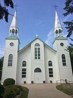 Saint-Denis Roman Catholic Church in Haywood | |
 Haywood Location of Haywood in Manitoba | |
| Coordinates: 49°40′0″N 98°11′47″W / 49.66667°N 98.19639°WCoordinates: 49°40′0″N 98°11′47″W / 49.66667°N 98.19639°W | |
| Country |
|
| Province |
|
| Region | Central Plains |
| Census Division | No. 9 |
| Government | |
| • Governing Body | Rural Municipality of Grey Council |
| • MP | Candice Bergen |
| • MLA | Blaine Pedersen |
| Time zone | UTC−6 (CST) |
| • Summer (DST) | UTC−5 (CDT) |
| Postal Code | R0G 0W0 |
| Area code(s) | 204, 431 |
| NTS Map | 062G09 |
| GNBC Code | GAKOF |
Haywood is an unincorporated community recognized as a local urban district[1] in the province of Manitoba, Canada. Haywood is situated in the Rural Municipality of Grey, east of St. Claude and west of Elm Creek.
The community includes a church, a hall, a cemetery, and many other public areas and services that most communities provide. Haywood, however, does not have a school, and therefore, students ride the bus to St. Claude, a neighbouring community to the west.
Haywood was founded in 1907. The centennial anniversary was acknowledged in 2007. The event was celebrated by featuring a float parade, sponsored by a number Haywood and St. Claude businesses and families. A supper was later held in the community hall, followed by a show of fireworks, at around 11:00 PM that night.
References
- ↑ "Local Urban Districts Regulation". Government of Manitoba. April 23, 2016. Retrieved April 24, 2016.
Places adjacent to Haywood, Manitoba | ||||||||||
|---|---|---|---|---|---|---|---|---|---|---|
| ||||||||||
| Cities | 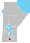 | ||
|---|---|---|---|
| Villages |
| ||
| Rural municipalities | |||
| First Nations | |||
| Indian reserves | |||
| Unincorporated communities | |||