Cuautla, Morelos
| Cuautla | |
|---|---|
| Municipal and rural | |
 | |
|
Cuautla Location in Mexico | |
| Coordinates: 18°48′44″N 99°57′21″W / 18.81222°N 99.95583°W | |
| Country |
|
| State | Morelos |
| Area | |
| • Total | 153.651 km2 (59.325 sq mi) |
| Population (2005) | |
| • Total |
175, 208 (city) 160,285 (municipality)[1] |
| Time zone | UTC-6 (Tiempo_del_Centro) |
| • Summer (DST) | UTC-5 (Tiempo del Centro) |
| Area code(s) | 735 |
| Website | http://www.cuautla.gob.mx |
Cuautla (Nahuatl pronunciation: [ˈkʷaʍt͡ɬa], meaning "where the eagles roam"), officially La heroica e histórica Cuautla, Morelos (The Heroic and Historic Cuautla, Morelos) or H. H. Cuautla, Morelos, is a city and municipality in the Mexican state of Morelos, about 104 kilometers south of Mexico City. In the 2010 census the city population was 154,358.[2] The municipality covers 153.651 km² (59.325 sq mi). Cuautla is the third most populous city in the state, after Cuernavaca and Jiutepec. The city was founded on 4 April 1829. Cuautla is constantly changing, as American enterprises are emerging in Morelos.
History
Cuautla was the scene of one of the fiercest battles of the War of Independence during a siege which began on 19 February and ended on 2 May 1812. The city was taken by forces of the priest and General José María Morelos y Pavón, who defended it against the Spaniard General Félix María Calleja for weeks before having to retreat.
During the Mexican Revolution Cuautla was the first city conquered by the forces of Emiliano Zapata, who was born in Anenecuilco, just south of Cuautla.
Daily life
In most family households, both parents work full-time, while their child either attends school or follows his parents' career. Children of this area have little access to computers and internet, unless of course the household income is above average. Those who do attend a school of any sort typically have little to no homework and spend their free time outdoors. Many children enjoy trips to small family-owned stores, which have games which are referred to as "las maquinitas," which are used for social gatherings and, to some extent, gambling. Also, many families attend the nearest chapel regularly, but many do not have the time for this.
Culture
Given that Cuautla lies in the heart of Southern Mexico, cultural diversity is inevitable. This city is not only made up of Mexican born men and women. Cuautla is home to many from other parts of Mexico, and even some from the Central American countries El Salvador and Honduras. Many acquire nicknames for that very reason, such as Catracho, which is a common nickname for people from Honduras, or Mojarra, for someone from a further South American country. Along with the nicknames, traditions and ways of life vary due to the many nationalities in Morelos.
Celebrations
Keeping in mind these are only some of many, here are some celebrations, that do not only originate in Mexico, that the people of Cuautla consider traditions:
- 6 January: Día de Reyes
- 5 February: Día de la Constitución
- 19 February: Anniversary of the start of 1812 siege of Cuautla
- 8 March: Día Internacional de la Mujer
- 2 May: Anniversary of the end of 1812 siege of Cuautla
- 16 September: Mexican Indepence Day
- 30 September: Anniversary of birth of the General José María Morelos y Pavón
- 8 August: Anniversary of birth of the General Emiliano Zapata Salazar
- 2 November: Day of the Death
Industry
This city is the heart of the sugar market in Morelos. Fields cover much of the rural areas, and have been around since the 1600s. Sugar has been a large part of Morelos' economy, and continues to be so today. Many spend their days tending only to the sugar cane, and after the season (typically the harvest is made in the dry season), campesinos cut the cane, extract the sugar, and burn the fields. Also another large contributor to Cuautla's economy, is the construction workers, and the cement business. Building homes with nothing but metal rods, cinder blocks, concrete, and occasionally tile, young men, middle aged men, and even men considered senior citizens in countries such as the United States of America, work from sun up to sun down making on average 100 Pesos a day. 100 Pesos today (14 February 2015) is equivalent to $6.71 USD. Apart from that, cement companies such as Cemex and Moldes de Colima fuel economic competition in this city, many of which not only make cement, but also try to compete in the production of asphalt, cinder blocks and gypsum.
Transportation
Some roads in Cuautla are not paved.
Public transportation is mainly dominated by a metro-bus system. These buses are referred to as "combis." These buses are small, and can hold up to roughly 10 people. Also, taxis are available. Cuautla contains many bus terminals, for long distance travels, such as the Terminal Central de Autobuses del Norte, with destinations as far as Monterrey, Nuevo Laredo and Ciudad Juarez.
Geography
Location
Cuautla is located on the eastern side of Morelos, on the geographic coordinates 18°49' N Latitude and 99°01' E Longitude, with an altitude of 1294 feet above sea level.[3]
Also, Cuautla borders the cities of Atlatlahucan, Ayala, Yautepec, Yecapixtla and Oaxtepec.
Distance from well known parts of Mexico
Size
Cuautla covers roughly 153,651 km², which is about 3% of the overall size of Morelos.[10]
Attractions
The area is a tourist-friendly region with abundant hot springs and health spas/resorts. It features many archeological sites such as Chalcatzingo and indigenous communities such as the Tepoztlán and Tetelcingo among others. Agua Hedionda (Spanish: Stinky Water), classified as one of the important water springs of the world due to its chemical composition, is also located in this little city. These waters have a characteristic smell reminiscent of rotten eggs because of their sulfur content.
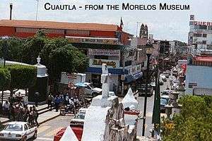
The Morelos Museum contains artifacts and descriptions about Mexico's War of Independence from Spain. It honors José María Morelos, whose rebel troops managed to hold off Royalist troops for 58 days. The Museum adjoins the old narrow-gauge railroad which was used to haul sugar cane to the local mills. The narrow-gauge was retired in 1973. The tomb of the famous Mexican revolutionary hero Emiliano Zapata is also located in this city, and every year several festivities are held around the anniversary of his death.
The Tren Escénico is a 3 ft (914 mm) narrow gauge[11] tourist railroad offering train rides pulled by an historic steam locomotive once used by the former Interoceanic Railway of Mexico.
Architecture
The vast majority of buildings in Cuautla, are made of stone and cement with metal rod reinforcements. Also, many homes in this city, are made with only cinder blocks, cement, and a tin roof. Many of these homes also lack electricity and running water. Nearly all homes have a "tinaco," which is a large plastic container for water, which is refilled regularly by the city. These containers let water out into pipes which can be opened or closed to wash clothes and dishes, or to bathe.
Weather
The city is quite warm year-round. In the winter, there is a slight decrease in both the daytime and nighttime temperatures, and because of Cuautla's proximity to the Tropic of Cancer and its altitude (about 4,500 feet above sea level), the nighttime temperatures year-round usually average about 57 °F (14 °C). On the other hand, because Cuautla is somewhat close to the Equator, temperatures year-round tend to reach into the mid 80s to lower 90s°F (upper 20s°C to the lower 30s°C) even during the winter, and in spring on many days the daytime temperatures may reach well into the upper 90s°F (upper 30s°C).
Religion
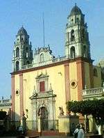
The dominant religion in Cuautla is Roman Catholicism. There are 22 registered churches in the municipal area.[10]
See also
References
- ↑ "Instituto Nacional de Estadística y Geografía (INEGI)". www.inegi.org.mx.
- ↑ "Cuautla de Morelos (Cuautla, Morelos, Mexico) - Population Statistics, Charts, Map, Location, Weather and Web Information". www.citypopulation.de.
- ↑ "CUAUTLA (Cuautla, Morelos)". pueblosamerica.com.
- ↑ "Distancia entre ciudad de mexico y cuautla". mx.lasdistancias.com.
- ↑ "Distancia entre monterrery y cuautla". mx.lasdistancias.com.
- ↑ "Archived copy". Archived from the original on 2 February 2015. Retrieved 22 December 2017.
- ↑ "Distancia entre Veracruz y cuautla". mx.lasdistancias.com.
- ↑ "Distancia entre yucatan y cuautla". mx.lasdistancias.com.
- ↑ "Archived copy". Archived from the original on 2 February 2015. Retrieved 22 December 2017.
- 1 2 es:Cuautla de Morelos
- ↑ "Surviving Steam Locomotives in Morelos". www.steamlocomotive.com.
Sources
(in Spanish)
- 2005 Census population data statistics INEGI: Instituto Nacional de Estadística, Geografía e Informática (National Institute of Statistics, Geography, and Information)
- Morelos Enciclopedia de los Municipios de México (Encyclopedia of Mexican Municipalities)
External links
(in Spanish)
- Ayuntamiento Constitucional de Cuautla (Constitutional Council of Cuautla) Official website
- Guide to Cuautla attractions
Coordinates: 18°49′N 98°57′W / 18.817°N 98.950°W
|