Tepoztlán
Tepoztlán (Nahuatl ![]()
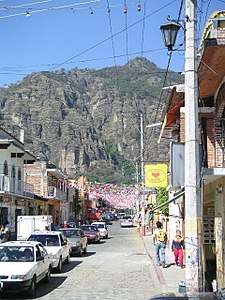
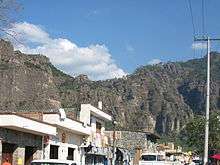
The town is a popular tourist destination near Mexico City. The town is famous for the remains of El Tepozteco temple built on top of the nearby Tepozteco Mountain, as well as for the exotic ice cream flavors prepared by the townspeople.
Tepoztlán was named a "Pueblo Mágico" in 2002 but its title was removed in 2009 for failure to maintain the requirements. In 2010 Tepoztlán addressed these problems and recovered the Pueblo Mágico title.
Etymology
Tepoztlán is derived from Nahuatl and means "place of abundant copper" or "place of the broken rocks."[1] This is derived from the words tepoz-tli (copper) and tlan ("place of/place of abundance").[2][3]
Climate
The climate around the Tepoztlán Sierra (where el Tepozteco is located) shows temperate as well as some subtropical variations. The rainy season starts during the summer and ends at the beginning of autumn. Precipitation reaches 1000 mm/yr in the Tepoztlán Valley and up to 1200 mm/yr in the mountains.
Economy
Agriculture specially growing of maize, chili and tomatoes. livestock growing. Traditional pottery and handicrafts (for which there is a lively weekend market or tianguis).
Tourism. Nowadays Tepoztlán gets its most important income through tourism. People visit the town for its authentic traditional environment, along with the pyramid and several communities with ecological or progressive thinking.
Real estate. The legal system that regulates possession of land in Tepoztlán is communal. Under that legal framework, land in Tepoztlán cannot be purchased. In case of problems, neither financial nor judicial institutions can support ownership claims. [4]
Owned by the Asociación de Scouts de México, A.C., located near Tepozteco mountain, Meztitla is the National Scout Camp School. Although Meztitla is frequented by Scouts of Mexico and from around the world, it is also open to the general public.
History

According to myth, Tepoztlan is the birthplace of Quetzalcoatl over 1200 years ago, the feathered serpent god widely worshipped in ancient Mexico.[5] It has not yet been possible to determine who first inhabited the area. The earliest findings of pottery and other ceramic utensils date back to approximately 1500 BCE.
By the 10th century CE the Toltec culture was predominant in the area. Tepoztlán is said to have been the birthplace of Ce Acatl, a very important Toltec leader, later known as Topiltzin Ce Acatl Quetzalcoatl, and who may be the possible historical basis of the Mesoamerican god Quetzalcoatl. During the Spanish Conquest Hernán Cortés is said to have ordered the town razed after the refusal of the town leaders to meet him. This event was chronicled by Bernal Díaz del Castillo in The Conquest of New Spain.
Surrealist painter Wolfgang Paalen lived and worked in Tepoztlàn during his last Mexican period (1954–59).
Indie musician Conor Oberst recorded his self-titled album in the city in 2008, although in the sleeve the city is misspelled "Tepotzlan."
The municipality
The municipality is one of 17 municipalities that border Mexico City. It borders the Milpa Alta borough at the south side of the capital city.
Towns and villages
The largest localities (cities, towns, and villages) are:[6]
| Name | 2010 Census Population |
|---|---|
| Tepoztlán | 14,130 |
| Santa Catarina | 4,521 |
| Unidad Habitacional Rinconada Acolapa | 3,205 |
| Loma Bonita | 2,332 |
| San Juan Tlacotenco | 1,890 |
| Santo Domingo Ocotitlán | 1,541 |
| Tetecolala | 1,449 |
| San Andrés de la Cal | 1,383 |
| Colonia Obrera | 1,316 |
| Colonia Ángel Bocanegra (Adolfo López Mateos) | 1,235 |
| Amatlán de Quetzalcóatl | 1,029 |
| Santiago Tepetlapa | 847 |
| Total Municipality | 41,629 |
See also
References
- ↑
- ↑
- ↑ "Some Mexican Place Names in Nahuatl". Azteca.net. Retrieved 30 December 2017.
- ↑ "Despojo de terreno en Tepoztlán; autoridades hacen caso omiso: De Kuri en MVS - Aristegui Noticias". Aristeguinoticias.com. Retrieved 30 December 2017.
- ↑ Noble, John (2000), Mexico City, Oakland, California: Lonely Planet, ISBN 1-86450-087-5
- ↑ 2010 census tables: INEGI Archived 2013-05-02 at the Wayback Machine.
Other sources
- Encyclopedia of Mexican Municipalities: Tepoztlán - In Spanish.
External links
| Wikimedia Commons has media related to Tepoztlán. |
- Meztitla(ASMAC website)- In Spanish.
- 360 Virtual Tour Ex-convent of Dominico de la Natividad .

| Authority control |
|---|