Crow River (Minnesota)
| Crow River (Khaŋǧí Šúŋ Wakpa) | |
| River | |
 | |
| Country | United States |
|---|---|
| State | Minnesota |
| Mouth | Mississippi River |
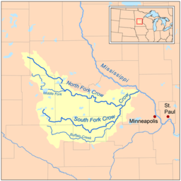 Map of the Crow River watershed. | |
The Crow River is a tributary of the Mississippi River in south-central Minnesota in the United States. It drains a watershed of 2,756 square miles (7,140 km2).
Name
The earliest record of the name for Crow River is "Karishon River", reflecting the Dakota language Khaŋǧí Šúŋ Watpá (now Wakpá), meaning "The Large Wing-feather of the Crow River". In other documents, this was translated as "Crow Wing River", or by its Ojibwe language name "Undeg-sipi" (from Aandego-ziibi), meaning "Crow River". Early explorers recorded the name of this river in various ways: "Goose River" by Jonathan Carver, "Rook's River" by Giacomo Beltrami, and as "Karishon or Crow River" by Joseph Nicollet.[1] The North Fork of the Crow River was named by the Ojibwe Indians for the bird they called the "marauder of newly planted corn."[2]
Hydrography
The Crow River flows for most of its length as three streams:
- The North Fork Crow River, 157.5 miles (253.4 km) long,[3] flows from Grove Lake in eastern Pope County and follows a generally east-southeastward course through southwestern Stearns, northeastern Kandiyohi, northern Meeker and central Wright counties, through Rice Lake and Lake Koronis and past the towns of Regal, Paynesville and Kingston. A minor headwaters tributary of the North Fork is named the Skunk River.
- The Middle Fork Crow River, 45.1 miles (72.6 km) long,[3] rises near Belgrade in southwestern Stearns County and flows into Kandiyohi County, initially southward through Mud Lake and Nest Lake and past the town of New London, then eastward through Green Lake and Calhoun Lake and into northern Meeker County, where it joins the North Fork.
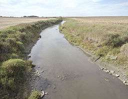
- The South Fork Crow River, 116.0 miles (186.7 km) long,[3] flows from Wakanda and Little Kandiyohi lakes in south-central Kandiyohi County and follows a generally eastward course through southwestern Meeker, northern McLeod, northwestern Carver and southeastern Wright counties, past the towns of Cosmos, Hutchinson, Lester Prairie, Mayer, Watertown and Delano. Portions of the South Fork's upper course have been heavily straightened and channelized.
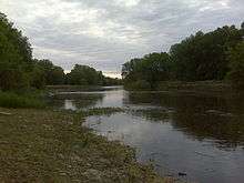
The north and south forks converge at Rockford to form the Crow River, which flows for 24.8 miles (39.9 km) northeastward to the Mississippi River.[3] The river's course is used to define the boundary between Wright and Hennepin counties.
The Crow flows through Greenfield, Hanover, St. Michael, Otsego and Dayton; it enters the Mississippi River from the south at the common boundary between Otsego and Dayton.
See also
Coordinates: 45°14′45″N 93°31′21″W / 45.2457984°N 93.5224579°W[4]
References
- ↑ Pike, Zebulon Montgomery. 1895. The expeditions of Zebulon Montgomery Pike, to headwaters of the Mississippi River, through Louisiana Territory, and in New Spain, during the years 1805-6-7.
- ↑ Minnesota DNR - Crow River, North Fork
- 1 2 3 4 U.S. Geological Survey. National Hydrography Dataset high-resolution flowline data. The National Map Archived 2012-04-05 at WebCite, accessed November 29, 2012
- ↑ U.S. Geological Survey Geographic Names Information System: Crow River
- Columbia Gazetteer of North America entry
- Waters, Thomas F. (1977). The Streams and Rivers of Minnesota. Minneapolis: University of Minnesota Press. ISBN 0-8166-0960-8.