Cross Gates
| Cross Gates | |
|---|---|
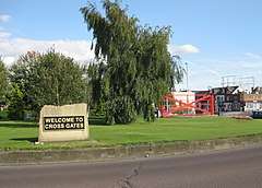 Welcome to Cross Gates roundabout with Cross Gates Sculpture | |
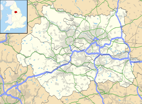 Cross Gates Cross Gates shown within West Yorkshire | |
| Population | 22,099 (Including Austhorpe. Ward of Cross Gates and Whinmoor) |
| OS grid reference | SE362345 |
| Metropolitan borough | |
| Metropolitan county | |
| Region | |
| Country | England |
| Sovereign state | United Kingdom |
| Post town | LEEDS |
| Postcode district | LS15 |
| Dialling code | 0113 |
| Police | West Yorkshire |
| Fire | West Yorkshire |
| Ambulance | Yorkshire |
| EU Parliament | Yorkshire and the Humber |
| UK Parliament | |
Cross Gates (often spelled Crossgates)[1] is a suburb in east Leeds, West Yorkshire, England. It is situated between Seacroft and Swarcliffe to the north, Whitkirk and Colton to the south, Killingbeck to the west and Austhorpe to the south east. Manston and Pendas Fields are generally regarded as part of Cross Gates. Cross Gates had a population of 7,770 in 2011.[2] Despite being a relatively small area, it serves as an important transport hub for the nearby large housing estates of Seacroft, Whinmoor and Gipton. By a later revision of the 2011 Census the ward had been renamed Crossgates and Whinmoor. This ward had a population of 22,099.[3]
Location
The suburb is 4 miles (6 km) to the east of Leeds city centre and lies in the LS15 Leeds postcode area.
History
Cross Gates means "crossroads" from Old English cros "cross" (as in Crossens) and Old Norse gata "street, gait" (not 'gate') . An alternative theory is that the name is derived from its location between the parishes of Whitkirk and Barwick where the boundary was marked by 'gates'.[4] The name was recorded as Crosget in 1129. Cross Gates was originally part of Austhorpe, as were Colton and Barrowby, which is indicated through various streets in Cross Gates beginning with "Austhorpe".
Until the building of the railway, Cross Gates was a quiet village. However, Leeds' industrialisation, as well as the building of the railway, developed Cross Gates into a 'commuter village'. At this time Cross Gates was 'well removed' from the city and the collieries to the west of the village, so Cross Gates began to attract Leeds' more affluent residents. Cross Gates' development however had always been attributable to its proximity to Leeds. Before 1900 there was little evidence of Cross Gates, and unlike nearby suburbs such as Halton, Seacroft and Austhorpe there is no mention of Cross Gates in the Domesday Book. The earliest housing in Cross Gates was built for the workers at Cross Gates Colliery.[5]
In the twentieth century Cross Gates effectively became a suburb of Leeds, with the open fields in between being developed into housing. This also led to much development around Cross Gates, including the building of the Cross Gates estate, a development of council housing and private development around Austhorpe, Whitkirk and Manston. Cross Gates quickly outgrew its amenities, which led to the building of the Arndale Centre.
Barnbow Tragedy

The worst tragedy ever to happen within Leeds (in terms of fatalities) was the Barnbow tragedy of 5 December 1916. 35 workers (all women aged 14 or over) were killed in the Barnbow Munitions Factory, which later became ROF Barnbow. The plant employed 16,000 workers, from Leeds, Selby, Wakefield, Tadcaster and Wetherby and had its own railway station to cope with the daily influx of workers. The railway station had an 850-foot (260 m) platform and 38 special trains from surrounding towns and cities. An explosion from Hall 42 killed 35 workers and mutilated many more. Mechanic, Mr William Parking was presented with an engraved silver watch for his bravery in saving factory workers during the incident.[6] There are two memorials: one in Manston Park and one on Cross Gates Road by the roundabout with the Ring Road.
Cross Gates Shopping Centre
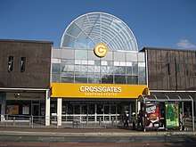
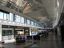
The demolition of Gas holder Number Two at the Cross Gates Gasworks made way for a shopping centre in Cross Gates as some felt that Cross Gates was badly lacking in amenities. This led to the building of the Cross Gates Arndale Centre. It opened on 21 September 1967 and was the first indoor "American-style" shopping mall in England. It was situated on the old coal and goods yards which were behind what is now the parade of shops at the bottom of Station Road, just north of the Station Pub. In the mid-1980s it was renamed Cross Gates Shopping Centre and was renamed again into Crossgates in January 2005 as a consequence of new ownership and re-branding. This is a large indoor shopping centre (approximately 200,000 sq.ft) containing retailers such as Poundland, Peacocks, Newlook, Select, Iceland, Wilko, Home Bargains, Superdrug and Bon Marche. There is also a LB's situated upstairs, Flavours Cafe, and several banks and building societies with almost 60 stores in total. The Centre is 'L'-shaped, with both legs being approximately equal in length. The Centre is single storey, except for the central part where there is a second storey containing LB's cafe, and an external unit with an East of India restaurant. The barrelled roofs at the Station Road and Austhorpe Road entrances were added several years after the shopping centre's construction in 1967 - they were refurbished in 2001. There have been many small-scale renovations in the Centre since its construction, including the car parks, which are operated on a ticket-on-entry and pay-on-foot system. The Centre is bright, clean, modern and well kept.
Other shopping facilities in Cross Gates are found along Austhorpe Road. Cross Gates' main supermarket was originally a Fine Fare next to the Methodist Church on Austhorpe Road, and then the GEM supermarket (formerly the Regal Cinema which was demolished for GEM to be built) which later became an Asda on the western side of the roundabout where the Ring Road meets Cross Gates Road. This later became a 'Questword' supermarket and is now Mecca Bingo. There are also nearby shopping facilities in Halton (among them a newly built Lidl), Seacroft (the Seacroft Shopping centre, with a large Tesco Extra), and Colton (the Colton Retail Park), which has a Sainsbury's, DW Sports and an Argos, as well as various eating locations.
Housing
The area's housing includes detached houses, semi-detached houses and terraced houses. A block of new low-rise flats has been built opposite the Crossgates Shopping Centre, and apartments are being sold and rented at very high prices. Austhorpe Road and the areas surrounding Marshall Street are made up largely of Victorian through terraces. There are some upmarket Victorian villas around Tranquility Avenue.
Manston Park
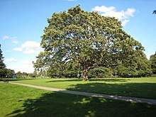
Manston Park is a large park in Cross Gates with football pitches, a bowling green, tennis courts and a playground.
Transport
Cross Gates railway station is on the Leeds to Selby line, now part of the York and Selby Lines in the timetables. It is a well used stop for residents commuting to Leeds or York city centres. In June 2006 Cross Gates won the award for "Best Kept Railway Station" in all of Yorkshire, having made major strides in the refurbishment of the station. Cross Gates is also close to the A64 dual carriageway and the M1. The A6120 Leeds Outer Ring Road "Station Road" is the main road through the area.
Industry

A Royal Ordnance Factory, ROF Leeds, was built at Barnbow, off Manston Lane, producing guns and ammunition for the army and navy. The building was bought by Vickers Defence Systems and produced the Challenger 2 tank before it closed in 2004. The bus manufacturer Optare, formerly "Charles H. Roe Ltd", also had a factory on Manston Lane before it also closed in 2011 when they moved to Sherburn in Elmet, and the haulage company J Long & Sons are based on Sandleas Way.
'Gates' sculpture
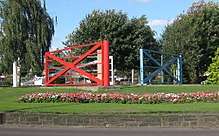
In 2009 the council developed the roundabout on the Leeds Ring Road on the North side with 3 stone signs saying "Welcome to Cross Gates" and a sculpture composed of 3 large metal gates by architect John Thorp, at a cost of £143000.[7] They were originally painted red, black and white, but this was changed to the present red, blue and silver,as the original colours are those of Manchester United.[7] The sculpture is meant to represent Cross Gates metaphorically, each gate having a large 'X' in steel in its design to reflect the history of the town's name. Local residents have expressed different views on the structure, some finding it an asset to the area, others finding it an eyesore.
Comparison
Cross Gates lies in the LS15 postcode area. Here is a population breakdown of the postcode area in comparison with the UK population.
| Category | LS15 | UK average |
|---|---|---|
| Population density (people/sq mi) | 43.2 | 24.9 |
| Gender split (female/male) | 1.05 | 1.05 |
| Average commute | 6.1 miles | 8.73 miles |
| Average age | 38 | 39 |
| Home ownership | 16% | 16.9% |
| Student population | 2.4% | 4.4% |
| People in good health | 69% | 69% |
Location grid
Places adjacent to Cross Gates | ||||||||||
|---|---|---|---|---|---|---|---|---|---|---|
| ||||||||||
References
- ↑ "Crossgates library". Leeds City Council. Retrieved 8 February 2014.
- ↑ 29 output areas make up Cross Gates, all in the Cross Gates and Whinmoor ward: http://ukcensusdata.com/cross-gates-and-whinmoor-e00057504#sthash.UrSyITWQ.dpbs
- ↑ UK Census (2011). "Local Area Report – Cross Gates and Whinmoor Ward (as of 2011) (1237321077)". Nomis. Office for National Statistics. Retrieved 12 July 2018.
- ↑ "Leeds nostalgia: Cross Gates through history... from the 1970s to today". Yorkshire Evening Post. 12 February 2018. Retrieved 12 July 2018.
- ↑ ISBN 1-84151-063-7
- ↑ http://www.elhas.org.uk/reports/barnbowt.htm
- 1 2 "£143,000 Cross Gates sculptures row". Yorkshire Evening Post. 13 August 2009.
External links
| Wikimedia Commons has media related to Cross Gates. |
- YEP Cross Gates Today Community Website
- Crossgates Shopping Centre
- Crossgates Town Centre regeneration - Leeds City Council
- VE Day 60 Years:Leeds - Manufacturing at Cross Gates
- "The Ancient Parish of Whitkirk". GENUKI. Retrieved 29 October 2007. - Cross Gates was described as being in the parishes of Whitkirk and Barwick in Elmet
- "The Ancient Parish of Barwick in Elmet". GENUKI. Retrieved 29 October 2007. - Cross Gates was described as being in the parishes of Whitkirk and Barwick in Elmet
| About Leeds | |
|---|---|
| Parliamentary constituencies | |
| Government | |
| Areas (List) |
|
| |