Lilli Pilli, New South Wales
| Lilli Pilli Sydney, New South Wales | |||||||||||||||
|---|---|---|---|---|---|---|---|---|---|---|---|---|---|---|---|
 Lilli Pilli Point | |||||||||||||||
|
Lilli Pilli | |||||||||||||||
| Coordinates | 34°04′06″S 151°06′57″E / 34.06833°S 151.11583°ECoordinates: 34°04′06″S 151°06′57″E / 34.06833°S 151.11583°E | ||||||||||||||
| Population | 1,390 (2016 census)[1] | ||||||||||||||
| • Density | 1,540/km2 (4,000/sq mi) | ||||||||||||||
| Postcode(s) | 2229 | ||||||||||||||
| Area | 0.9 km2 (0.3 sq mi) | ||||||||||||||
| Location | 26 km (16 mi) south of Sydney CBD | ||||||||||||||
| LGA(s) | Sutherland Shire | ||||||||||||||
| State electorate(s) | Cronulla | ||||||||||||||
| Federal Division(s) | Cook | ||||||||||||||
| |||||||||||||||

Lilli Pilli is a small suburb in southern Sydney, in the state of New South Wales, Australia. Lilli Pilli is located 26 kilometres south of the Sydney central business district, in the local government area of the Sutherland Shire. There is also another Lilli Pilli in New South Wales (postcode 2536), located 12 kilometres south of Batemans Bay.
History
Lilli Pilli was named for the lilly pilly, the native myrtle that grew on the point. Thomas Holt (1811–88) owned most of the land that stretched from Sutherland to Cronulla, including land on the point. In 1840, parish maps also showed that 20 acres (8.1 ha) of land on the point were owned by Francis Mitchell. The public school opened in 1957, and celebrated its 50th anniversary in 2007.[2]
Geography
Lilli Pilli is located on the north shore of the Port Hacking estuary. The only adjacent suburbs are Caringbah South, Port Hacking and Dolans Bay. The villages of Maianbar and Bundeena are located on the opposite bank of Port Hacking.
Lilli Pilli is surrounded by Gannons Bay, Little Turriel Bay, Port Hacking River and Great Turriel Bay. Lilli Pilli Point is situated at the end of Lilli Pilli Point Road, off Port Hacking Road. Lilli Pilli Point Bushland Reserve overlooks The Royal National Park. This bushland reserve is a great secluded picnic area that is often protected from the wind. A rock ledge runs along the northern point up to Speed Alley. Many fishing spots can be found here, all the way to Little Turriell Bay.
Commercial area
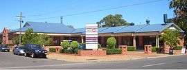
On the southern-end of Port Hacking road, a small group of shops are located in the adjacent suburb of Port Hacking. These include, "The Gum Tree Food Store", "Vintage Cellars", "D'lish on port", as well as a butcher, a hairdresser, and a beauty shop. However, these shops are located in Port Hacking.
After 30 years in business, the Gum Tree Food Store shut its doors for the last time in May 2014. Following its closure, a convenience store was opened in early 2015. However, it has since closed and a bakery is expected to be opened in 2017.
There is also a small group of shops located in Port Hacking Road near Lilli Pilli, but technically in Caringbah South. It features an IGA, a patisserie/cafe, a pizzeria, a Thai take-away, and a boutique gift shop.
Transport
Transdev NSW operates bus route 977 from Lilli Pilli Point to Caringbah and Miranda.
Schools
- Lilli Pilli Primary School is on Lilli Pilli Point Road. The Lilli Pilli Kindergarten is located nearby in Caringbah. The school has many sporting achievements, including the winning of the PSSA Soccer Division One Cup in 2008.[3]
Sport and recreation
On The western side of Lilli Pilli Point Reserve there are some public baths and a fishing jetty. The baths are deep salt water baths that may be used by anyone that wishes to swim in the Port Hacking River protected by a net. There is a 20-metre hole just outside the baths where many fish swimming down river seem to gather and feed. The channel provides opportunities for catching fish on the changing tide. At low tide the channel can be swum and the sand bank can be walked on, almost the other side. Locals take their dogs across for play but are always careful about the rising tide which can pose problems if not watched.
Lilli Pilli is home to the Lilli Pilli Football Club.[4] Their homeground is Lilli Pilli Oval but other fields are also used such as Caringbah Oval, Solander Fields, Captain Cook Oval and Breen Park. Lilli Pilli is also home to 1st Lilli Pilli Sea Scouts.
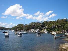
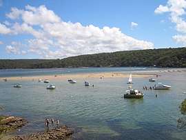 Port Hacking estuary at Lilli Pilli
 Port Hacking estuary at Lilli Pilli
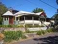 house on Lilli Pilli Point
References
- ↑ Australian Bureau of Statistics (27 June 2017). "Lilli Pilli (State Suburb)". 2016 Census QuickStats. Retrieved 9 November 2017.

- ↑ The Book of Sydney Suburbs, Compiled by Frances Pollon, Angus & Robertson Publishers, 1990, Published in Australia ISBN 0-207-14495-8, p51
- ↑ Lilli Pilli Primary School
- ↑ Lilli Pilli Football Club
External links
| Wikimedia Commons has media related to Lilli Pilli, New South Wales. |