Cowden, East Riding of Yorkshire
| Cowden | |
|---|---|
 Cowden Cowden shown within the East Riding of Yorkshire | |
| OS grid reference | TA239403 |
| • London | 160 mi (260 km) S |
| Civil parish | |
| Unitary authority | |
| Ceremonial county | |
| Region | |
| Country | England |
| Sovereign state | United Kingdom |
| Post town | HULL |
| Postcode district | HU11 |
| Dialling code | 01964 |
| Police | Humberside |
| Fire | Humberside |
| Ambulance | Yorkshire |
| EU Parliament | Yorkshire and the Humber |
| UK Parliament | |
Cowden (or Little Cowden) is a hamlet in the East Riding of Yorkshire, England, in an area known as Holderness. It is situated approximately 5 miles (8 km) south of Hornsea and lies just east of the B1242 road towards the North Sea coast. Its name means a hill where charcoal was burnt.[1]
It forms part of the civil parish of Mappleton.
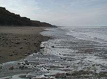
Lark Hill Beach
The Royal Air Force operated a 600-acre (240 ha) bombing range on the beach at Cowden between 1959 and 1998. The range was closed due to coastal erosion, which is quite common on the East Riding coast. The erosion sometimes reveals buried ordnance which requires the RAF bomb disposal team (No. 5131(BD) Squadron) to deploy north from RAF Wittering in Cambridgeshire to make the old bombs safe.[2][3][4]
References
- ↑ Ekwall, Eilert (1991). The concise Oxford dictionary of English place names. Oxford: Clarendon Press. p. 126. ISBN 9780198691037.
- ↑ "The beach where it's not safe to pick up ?the shells". The Yorkshire Post. 26 July 2012. Retrieved 13 March 2018. (Subscription required (help)).
- ↑ Townend, Jon (26 July 2012). "BLOWN AWAY: E YORKS: Bombs and rockets made safe on old beach target range". Hull Daily Mail. p. 18. ISSN 1741-3419.
- ↑ Burkeman, Oliver (1 September 2000). "National Roundup: Erosion tips RAF shells on to beach". The Guardian. p. 8. ISSN 0261-3077.
- Gazetteer — A–Z of Towns Villages and Hamlets. East Riding of Yorkshire Council. 2006. p. 4.
External links
| Wikimedia Commons has media related to Cowden. |
- Cowden in the Domesday Book
This article is issued from
Wikipedia.
The text is licensed under Creative Commons - Attribution - Sharealike.
Additional terms may apply for the media files.