Snaith
| Snaith | |
|---|---|
 St Laurence Priory Church, Snaith | |
 Snaith Snaith shown within the East Riding of Yorkshire | |
| OS grid reference | SE642220 |
| • London | 160 mi (260 km) SSE |
| Civil parish | |
| Unitary authority | |
| Ceremonial county | |
| Region | |
| Country | England |
| Sovereign state | United Kingdom |
| Post town | GOOLE |
| Postcode district | DN14 |
| Dialling code | 01405 |
| Police | Humberside |
| Fire | Humberside |
| Ambulance | Yorkshire |
| EU Parliament | Yorkshire and the Humber |
| UK Parliament | |
Snaith is a town in the East Riding of Yorkshire, England, approximately 6 miles (9.7 km) west of Goole on the A1041 at its junction with the A645. It is 1 mile (1.6 km) to the north of the M62 motorway, just south of the River Aire.
The town of Snaith with the villages of East Cowick and West Cowick form the civil parish of Snaith and Cowick. The Snaith and Cowick civil parish had 3,579 inhabitants and 1,492 households in the 2011 UK census.[1] This was an increase on 3,028 inhabitants and 1,228 households in the 2001 UK census.[2] The town continues to grow in size, due to the expanding Ben Bailey housing estate.
Snaith is the focal point of the local rural area. It has primary and secondary schools. The town exit and entry to the M62 is approximately 5 miles (8 km) away, giving access to Hull, Doncaster, Goole, Leeds and Castleford. It is approximately 20.6 miles (33 km) from York. Selby is 7 miles (11 km) away, with Carlton and Camblesforth between.
Snaith was part of the Goole Rural District in the West Riding of Yorkshire from 1894 to 1974, then in Boothferry district of Humberside until 1996.
Toponymy
The name "Snaith" derives from the Old Scandinavian word sneith, meaning "Piece of land cut off".[3] Snaith was recorded in its modern-day form in c.1080, however in the Domesday Book of 1086, it was recorded as Esneid.
Parish church
The priory church of St Lawrence is low and wide, with pinnacles. The core of the church is Norman and Cruciform, and the tower is Early English and stands at the west end. The chancel is Decorated and the nave has Perpendicular arcades and a high clerestory. Glass in the chancel window is by Francis Spear and there is a notable monument to Viscount Downe by Francis Chantrey.[4] The church was designated a Grade I listed building in 1967 and is now recorded in the National Heritage List for England, maintained by Historic England.[5]
Amenities
Snaith has a library, post office, dental practice, doctor’s surgery, pharmacy, opticians and petrol station. There is also a Co-operative store, and a variety of small retail, service and food outlets, including takeaways. The town has five public houses. It also has a notable small brewery, The Old Mill Brewery, established in 1983 in a mill building dating back to 1791.
Schools in the town include Snaith Primary School and The Snaith School (secondary).
Transport
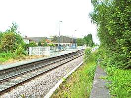
Snaith railway station is situated on the line approximately halfway between Hull and Leeds. It is served by a railway station, with a limited service on the Pontefract Line from Leeds to Goole.
The town also has a regular bus service, and is central to the 400 and 401 Arriva bus services, which usually commute hourly between Selby and Goole.
Sport
Snaith Juniors Football Club was formed in 1990 as Croda F.C. because the football pitch was in the grounds of Cowick Hall, then used by Croda International.[6] Snaith Juniors F.C. now play at Ben Bailey housing estate and hold football tournaments at the end of May each year. The council proposed making a cricket pitch for a town cricket team, but no land was available. The Garth, adjacent to the Methodist Chapel, was given to the people of Snaith for recreation and leisure.
References
- ↑ "Key Figures for 2011 Census: Key Statistics: Area: Snaith and Cowick CP (Parish)". Neighbourhood Statistics. Office for National Statistics. Retrieved 7 February 2013.
- ↑ "2001 Census: Key Statistics: Parish Headcounts: Area: Snaith and Cowick CP (Parish)". Neighbourhood Statistics. Office for National Statistics. Retrieved 11 September 2009.
- ↑ Ekwall, Eilert (1960). The concise Oxford dictionary of English place-names (4 ed.). Oxford: Clarendon Press. p. 428. ISBN 0-19-869103-3.
- ↑ Betjeman, John, ed. (1968). Collins Pocket Guide to English Parish Churches: the North. London: Collins. p. 349.
- ↑ Historic England. "Church of St Lawrence (1161899)". National Heritage List for England. Retrieved 10 August 2013.
- ↑ "Snaith Juniors FC History". Snaith Juniors FC. Retrieved 23 November 2015.
- Gazetteer — A–Z of Towns Villages and Hamlets. East Riding of Yorkshire Council. 2006. p. 10.
| Wikimedia Commons has media related to Snaith. |