Cousins Island
| Cousins Island, Maine | |
|---|---|
| Census-designated place | |
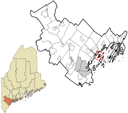 Location in Cumberland County and the state of Maine. | |
| Coordinates: 43°45′45″N 70°8′25″W / 43.76250°N 70.14028°WCoordinates: 43°45′45″N 70°8′25″W / 43.76250°N 70.14028°W | |
| Country | United States |
| State | Maine |
| County | Cumberland |
| Town | Yarmouth |
| Area | |
| • Total | 2.0 sq mi (5.1 km2) |
| • Land | 1.0 sq mi (2.7 km2) |
| • Water | 0.9 sq mi (2.4 km2) |
| Population (2010) | |
| • Total | 490 |
| • Density | 250/sq mi (96/km2) |
| Time zone | UTC-5 (Eastern (EST)) |
| • Summer (DST) | UTC-4 (EDT) |
| Area code(s) | 207 |
| FIPS code | 23-08500 |
Cousins Island is an island in Casco Bay within the town of Yarmouth in Cumberland County, Maine, United States. It is listed as a census-designated place, with a population of 490 as of the 2010 census.[1] The CDP is part of the Portland–South Portland–Biddeford, Maine Metropolitan Statistical Area.
The island is connected to mainland Maine by a bridge, built in 1955. It is also connected to Chebeague Island by a 15-minute ferry ride on the Chebeague Transportation Company's ferry, the Islander. The island's southwestern peninsula is the site of the Wyman Energy Center, an oil-fired electric power plant capable of producing up to 823 megawatts of electricity.[2] Wyman is a peaking power plant, which means it is only fired up to operate during times of high electricity demand in the region, such as hot summer days.
The island, Cousins River and Littlejohn Island are named after Englishman John Cousins (b. circa 1596, d. 1682), who emigrated from Marlborough, Wiltshire.
Geography
According to the United States Census Bureau, the CDP has a total area of 2.0 square miles (5.1 km2), of which 1.0 square mile (2.7 km2) is land and 0.93 square miles (2.4 km2), or 46.51%, is water.[3]
See also
References
- ↑ "Profile of General Population and Housing Characteristics: 2010 Demographic Profile Data (DP-1): Cousins Island CDP, Maine". U.S. Census Bureau, American Factfinder. Archived from the original on September 11, 2013. Retrieved June 12, 2012.
- ↑ http://www.eia.doe.gov/state/state_energy_profiles.cfm?sid=ME
- ↑ "Geographic Identifiers: 2010 Demographic Profile Data (G001): Brunswick Station CDP, Maine". U.S. Census Bureau, American Factfinder. Archived from the original on September 11, 2013. Retrieved June 12, 2012.
External links
- "Cousins Island". Geographic Names Information System. United States Geological Survey. Retrieved 2009-03-27.
Municipalities and communities of Cumberland County, Maine, United States | ||
|---|---|---|
| Cities | 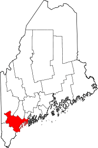 | |
| Towns | ||
| CDPs | ||
| Other villages | ||