Boon Island
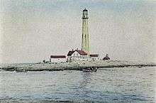
Boon Island is a barren piece of land located in the Gulf of Maine 6 miles (10 km) off the town of York on the Maine coast. The island is approximately 300 by 700 feet (90 by 210 m) in size at low tide, and is the site of Boon Island Light, the tallest lighthouse in New England.
It is often said that the island got its name when the coastal trading vessel, the Increase, wrecked on it in the summer of 1682. Four survivors — three white men and one Indian — spent a month on the island, subsisting on fish and gulls' eggs. One day they saw smoke rising from Mount Agamenticus several miles away in York, so they built a fire to attract attention to their plight. The Indians at Mount Agamenticus saw the smoke from the island and the castaways were soon rescued. Seeing their survival as a boon granted by God, the men are said to have dubbed it Boon Island. It's a good story but in fact John Winthrop mentions in his journal passing by Boon Island by name some eighty years earlier. Celia Thaxter called the ironically named Boon Island "the forlornest place that can be imagined."
More famous was the shipwreck on December 11, 1710, of the British merchant ship, Nottingham Galley. All fourteen crewmen aboard survived the initial wreck, however two died from their injuries - the cook, who died a few days after the initial wreck, and a carpenter, who died two weeks after - and another two drowned attempting to reach the mainland on an improvised raft. The remaining ten crewmen managed to stay alive despite winter conditions with no food and no fire for twenty-four days, until finally rescued. They resorted to cannibalism, eating the Carpenter after his death, which gave the incident a notoriety that it retains even today.
The story also features a conflict between the captain and members of his crew, primarily his first mate, Christopher Langman. Langman, backed by two of his fellow crew mates, claimed that that Dean turned the ship over to French privateers and then planned to wreck the ship for insurance money. When his crew learned of this, they mutinied and forced Dean to continue to Boston, resulting in its wreck on Boon Island.[1] The crew also claimed that A vigorous public relations battle ensued in London the following summer between the captain and members of his unhappy crew, which also helped make the story famous in its day. The harrowing story was fictionalized by Kenneth Roberts in his 1956 novel Boon Island. The only non-fiction history of the event, "Boon Island: A True Story of Mutiny, Shipwreck and Cannibalism," by Andrew Vietze and Stephen Erickson, appeared in 2012. It is said that after the Nottingham Galley disaster, local fishermen began leaving barrels of provisions on Boon Island in case of future wrecks.
A wooden day beacon was erected in 1799 but lasted only five years. Fierce storms repeatedly scour Boon Island, which has an elevation of 14 feet (4.3 m) above sea level at its highest point. Violent seas can heave boulders across its surface, demolishing structures. A stone day beacon was constructed. In 1811, a stone lighthouse was built which stood 32 feet above the water, then rebuilt in 1831 to stand 49 feet. But damage from the elements was relentless. Consequently, in 1854–1855 the tallest lighthouse in New England was built — 133 feet (40 m) of massive granite blocks at a cost of US$25,000. It had a focal plane of 137 feet (42 m). Keepers willing to live in such a desolate place were few, arriving and departing in steady succession. Only one man seemed to thrive there; William W. Williams stayed 27 years and lived past the age of 90.
In February 1944, the Empire Knight, a 428-foot (130 m) British freight ship, ran aground at Boon Island and later broke into two sections. The stern section, which included the ship's cargo holds, sank in approximately 260 feet (80 m) of water, one and one half miles (2–3 km) from the Island. In August 1990, the United States Coast Guard became aware of the existence of a plan of stowage dating from 1944 for the ship indicating that 221 flasks (7,620 kg) of mercury may have been loaded onto the vessel. Investigation revealed that such flasks had been placed on the ship but had since deteriorated, releasing the mercury. An estimated 16,000 pounds (7¼ t) of mercury remain unrecovered and it is believed to have settled in the low point of the cargo hold.
In 1978, two lightkeepers on the island had to retreat from a powerful winter storm. They took shelter in the light chamber while the seas and wind demolished all other structures on the island. Water rose five feet up the tower and dislodged a number of its segments. Next day, they were rescued by helicopter. The tower was repaired and automated, no longer requiring a resident keeper. It is now powered by solar power.
In May 2000, the U.S. Coast Guard leased Boon Island Lighthouse to the American Lighthouse Foundation (ALF) for the restoration and preservation of the historic isolated sea sentinel.
In an effort to raise funds to restore and maintain the remote lighthouse, a fictional lighthouse nation declared its independence as The Republic of Boon Island on April 1, 2003.
In 2014 the lighthouse was sold to real estate developer Art Girard. It has since been sold several more times, and is currently own by Boon Island LLC.
See also
References
- History of Boon Island Light
- Balkan, Evan. Shipwrecked! Deadly Adventures and Disasters at Sea. Birmingham, AL: Menasha Ridge, 2008, pp. 34–42
- Vietze, Andrew and Erickson, Stephen, "Boon Island: A True Story of Mutiny, Shipwreck and Cannibalism" . Gilford, CT: Globe Pequot, 2012
- Specific
- ↑ Morse, Susan. "Historians to mark the 300th anniversary of Boon Island shipwreck". seacoastonline.com. Retrieved 2018-02-25.
Coordinates: 43°7′15″N 70°28′30″W / 43.12083°N 70.47500°W