Coulee, Mountrail County, North Dakota
| Coulee, North Dakota | |
|---|---|
| Unincorporated community | |
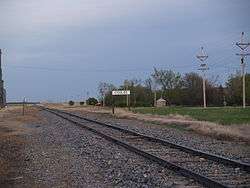 Railroad in Coulee | |
 Coulee, North Dakota  Coulee, North Dakota | |
| Coordinates: 48°32′43″N 102°00′42″W / 48.54528°N 102.01167°WCoordinates: 48°32′43″N 102°00′42″W / 48.54528°N 102.01167°W | |
| Country | United States |
| State | North Dakota |
| County | Mountrail |
| Elevation | 2,064 ft (629 m) |
| Time zone | UTC-6 (Central (CST)) |
| • Summer (DST) | UTC-5 (CDT) |
| Area code(s) | 701 |
| GNIS feature ID | 1028477[1] |
Coulee is an unincorporated community in Mountrail County, North Dakota, on the border of Ward County.[1]
It is the location of Our Savior's Scandinavian Lutheran Church, which is listed on the U.S. National Register of Historic Places.[2]
References
- 1 2 "Coulee". Geographic Names Information System. United States Geological Survey.
- ↑ National Park Service (2010-07-09). "National Register Information System". National Register of Historic Places. National Park Service.
Municipalities and communities of Mountrail County, North Dakota, United States | ||
|---|---|---|
| Cities | 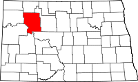 | |
| Townships |
| |
| Unorganized territory |
| |
| Unincorporated communities | ||
| Ghost town | ||
| Indian reservation | ||
| Footnotes | ‡This populated place also has portions in an adjacent county or counties | |
This article is issued from
Wikipedia.
The text is licensed under Creative Commons - Attribution - Sharealike.
Additional terms may apply for the media files.