Cortez, Florida
| Cortez, Florida | |
|---|---|
| CDP | |
 Location in Manatee County and the state of Florida | |
| Coordinates: 27°27′49″N 82°40′21″W / 27.46361°N 82.67250°WCoordinates: 27°27′49″N 82°40′21″W / 27.46361°N 82.67250°W | |
| Country |
|
| State |
|
| County | Manatee |
| Area | |
| • Total | 5.1 sq mi (13.3 km2) |
| • Land | 2.2 sq mi (5.7 km2) |
| • Water | 2.9 sq mi (7.6 km2) |
| Elevation | 3 ft (1 m) |
| Population (2000) | |
| • Total | 4,491 |
| • Density | 880.6/sq mi (337.7/km2) |
| Time zone | UTC-5 (Eastern (EST)) |
| • Summer (DST) | UTC-4 (EDT) |
| ZIP code | 34215 |
| Area code(s) | 941 |
| FIPS code | 12-14700[1] |
| GNIS feature ID | 0280867[2] |
Cortez, a census-designated place (CDP) in Manatee County, Florida, United States, is a small Gulf coast commercial fishing village that was founded by settlers from North Carolina in the 1880s. The population was 4,491 at the 2000 census. It is part of the Bradenton–Sarasota–Venice Metropolitan Statistical Area.
History
A post office has been in operation at Cortez since 1888.[3] The community may be named after Hernán Cortés, the Spanish Conquistador.[4]
Geography
Cortez is located at 27°27′49″N 82°40′21″W / 27.46361°N 82.67250°W (27.463550, -82.672610).[5]
According to the United States Census Bureau, the CDP has a total area of 5.1 square miles (13 km2), of which 2.2 square miles (5.7 km2) is land and 2.9 square miles (7.5 km2) (57.20%) is water.
Demographics
As of the census[1] of 2000, there were 4,491 people, 2,373 households, and 1,468 families residing in the CDP. The population density was 2,047.7 people per square mile (791.8/km²). There were 3,308 housing units at an average density of 1,508.3/sq mi (583.2/km²). The racial makeup of the CDP was 98.33% White, 0.16% African American, 0.20% Native American, 0.53% Asian, 0.16% from other races, and 0.62% from two or more races. Hispanic or Latino of any race were 1.31% of the population.
There were 2,373 households out of which 9.4% had children under the age of 18 living with them, 56.1% were married couples living together, 3.4% had a female householder with no husband present, and 38.1% were non-families. 31.9% of all households were made up of individuals and 20.8% had someone living alone who was 65 years of age or older. The average household size was 1.89 and the average family size was 2.29.
In the CDP, the population was spread out with 8.6% under the age of 18, 2.4% from 18 to 24, 13.8% from 25 to 44, 30.7% from 45 to 64, and 44.6% who were 65 years of age or older. The median age was 62 years. For every 100 females, there were 90.9 males. For every 100 females age 18 and over, there were 90.4 males.
The median income for a household in the CDP was $36,577, and the median income for a family was $48,750. Males had a median income of $32,188 versus $26,735 for females. The per capita income for the CDP was $26,476. About 7.3% of families and 9.4% of the population were below the poverty line, including 7.8% of those under age 18 and 10.1% of those age 65 or over.
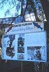
 Historical marker
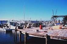 Shrimp, snapper, grouper, and stone crab fishing boats at Cortez
References
- 1 2 "American FactFinder". United States Census Bureau. Archived from the original on 2013-09-11. Retrieved 2008-01-31.
- ↑ "US Board on Geographic Names". United States Geological Survey. 2007-10-25. Retrieved 2008-01-31.
- ↑ "Manatee County". Jim Forte Postal History. Archived from the original on 15 July 2015. Retrieved 6 June 2015.
- ↑ Grimes, David (Nov 23, 1979). "The Legends Behind Manatee Names". Sarasota Herald-Tribune. pp. 3B. Retrieved 6 June 2015.
- ↑ "US Gazetteer files: 2010, 2000, and 1990". United States Census Bureau. 2011-02-12. Retrieved 2011-04-23.
Municipalities and communities of Manatee County, Florida, United States | ||
|---|---|---|
| Cities | 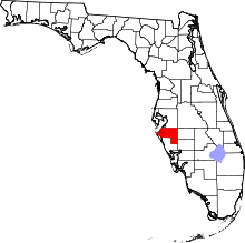 | |
| Town | ||
| CDPs | ||
| Unincorporated communities | ||
| Ghost towns | ||
| Footnotes | ‡This populated place also has portions in an adjacent county or counties | |
Cortez Historical Society web page has walking map tour and information about the area