Bradenton Beach, Florida
| Bradenton Beach, Florida | ||
|---|---|---|
| City | ||
| City of Bradenton Beach | ||
 Bradenton Beach | ||
| ||
| Motto(s): Blessed With History, Hospitality, Spirit | ||
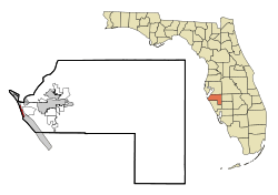 Location in Manatee County and the U.S. state of Florida | ||
 Bradenton Beach, Florida Location within the state of Florida  Bradenton Beach, Florida Bradenton Beach, Florida (the US) | ||
| Coordinates: 27°28′16″N 82°41′59″W / 27.47111°N 82.69972°WCoordinates: 27°28′16″N 82°41′59″W / 27.47111°N 82.69972°W | ||
| Country | United States of America | |
| State | Florida | |
| County | Manatee | |
| Settled | 1892 | |
| Incorporated (city) | 1952 | |
| Government | ||
| • Type | Weak Mayor-Commission | |
| • Mayor | Robert (Bob) Bartelt | |
| Area[1] | ||
| • Total | 1.19 sq mi (3.08 km2) | |
| • Land | 0.52 sq mi (1.33 km2) | |
| • Water | 0.67 sq mi (1.74 km2) | |
| Elevation | -10 ft (-3 m) | |
| Population (2010) | ||
| • Total | 1,171 | |
| • Estimate (2017)[2] | 1,269 | |
| • Density | 2,464.08/sq mi (950.75/km2) | |
| Time zone | UTC-5 (Eastern (EST)) | |
| • Summer (DST) | UTC-4 (EDT) | |
| ZIP codes | 34217-34218 | |
| Area code(s) | 941 | |
| FIPS code | 12-07975[3] | |
| GNIS feature ID | 0279312[4] | |
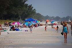
Bradenton Beach is a city on Anna Maria Island in Manatee County, Florida, United States. The population was 1,482 at the 2000 census, and 1,561 in the 2005 U.S Census estimates.[5] It is part of the Bradenton-Sarasota-Venice, Florida Metropolitan Statistical Area. The city occupies the southern part of Anna Maria Island and is one of three municipalities on the island. The others are Holmes Beach in the center and Anna Maria in the north.
History
A post office called Bradenton Beach has been in operation since 1941.[6] Bradenton Beach was incorporated in 1952. The city took its name from nearby Bradenton.[7]
Geography
According to the United States Census Bureau, the city has a total area of 1.1 square miles (2.8 km2), of which 0.6 square miles (1.6 km2) is land and 0.6 square miles (1.6 km2) (50.00%) is water. However, according to the Bradenton Beach government website, it has an area of five square miles.[8]
Demographics
| Historical population | |||
|---|---|---|---|
| Census | Pop. | %± | |
| 1960 | 1,124 | — | |
| 1970 | 1,370 | 21.9% | |
| 1980 | 1,603 | 17.0% | |
| 1990 | 1,657 | 3.4% | |
| 2000 | 1,482 | −10.6% | |
| 2010 | 1,171 | −21.0% | |
| Est. 2017 | 1,269 | [2] | 8.4% |
| U.S. Decennial Census[9] | |||
At the 2000 census,[3] there were 1,482 people, 803 households and 391 families residing in the city. The population density was 2,704.9 per square mile (1,040.4/km²). There were 1,762 housing units at an average density of 3,215.9 per square mile (1,236.9/km²). The racial makeup of the city was 98.52% White, 0.27% African American, 0.13% Native American, 0.13% Asian, 0.34% from other races, and 0.61% from two or more races. Hispanic or Latino of any race were 1.69% of the population.
There were 803 households of which 11.2% had children under the age of 18 living with them, 40.3% were married couples living together, 5.9% had a female householder with no husband present, and 51.2% were non-families. 40.1% of all households were made up of individuals and 13.1% had someone living alone who was 65 years of age or older. The average household size was 1.85 and the average family size was 2.40.
10.6% of the population were under the age of 18, 4.5% from 18 to 24, 24.9% from 25 to 44, 35.2% from 45 to 64, and 24.9% who were 65 years of age or older. The median age was 50 years. For every 100 females, there were 102.7 males. For every 100 females age 18 and over, there were 102.0 males.
The median household income was $32,318 and the median family income was $46,583. Males had a median income of $26,146 compared with $20,772 for females. The per capita income for the city was $22,850. About 3.9% of families and 7.3% of the population were below the poverty line, including 5.9% of those under age 18 and 6.9% of those age 65 or over.
Library
The Tingley Memorial Library is located at 111 2nd Street, North, behind City Hall.[10] It was built with a $600,000 bequest from the estate of Beulah Rebecca Hooks Hannah Tingley (1893–1986) and is maintained without the use of public funding. In 2000, Beulah Tingley was declared a "Great Floridian" by the state and a plaque attesting to that honor was placed above the front door of the library.[11]
References
- ↑ "2017 U.S. Gazetteer Files". United States Census Bureau. Retrieved September 20, 2018.
- 1 2 "Population and Housing Unit Estimates". Retrieved March 24, 2018.
- 1 2 "American FactFinder". United States Census Bureau. Archived from the original on September 11, 2013. Retrieved January 31, 2008.
- ↑ "US Board on Geographic Names". United States Geological Survey. October 25, 2007. Retrieved January 31, 2008.
- ↑
- ↑ "Manatee County". Jim Forte Postal History. Archived from the original on July 15, 2015. Retrieved June 6, 2015.
- ↑ Grimes, David (November 23, 1979). "The Legends Behind Manatee Names". Sarasota Herald-Tribune. pp. 3B. Retrieved June 6, 2015.
- ↑ "City of Bradenton Beach Florida". Cityofbradentonbeach.com. Archived from the original on April 11, 2014. Retrieved March 25, 2014.
- ↑ "Census of Population and Housing". Census.gov. Archived from the original on May 12, 2015. Retrieved June 4, 2015.
- ↑
- ↑ Archived November 22, 2010, at the Wayback Machine.
External links
| Wikimedia Commons has media related to Bradenton Beach, Florida. |
Municipalities and communities of Manatee County, Florida, United States | ||
|---|---|---|
| Cities | 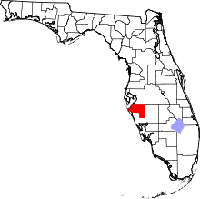 | |
| Town | ||
| CDPs | ||
| Unincorporated communities | ||
| Ghost towns | ||
| Footnotes | ‡This populated place also has portions in an adjacent county or counties | |