Cornwall Bridge
| Cornwall Bridge | |
|---|---|
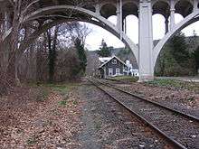 View of the NRHP listed Cornwall Bridge Railroad Station through an arched span of the Bridge, March 24, 2012 | |
| Coordinates |
41°49′10″N 73°22′22″W / 41.81944°N 73.37278°WCoordinates: 41°49′10″N 73°22′22″W / 41.81944°N 73.37278°W |
|
Bridge No. 560 | |
| Area | less than one acre |
| Architect | Connecticut Highway Department; Blakeslee, C.W. & Sons |
| NRHP reference # | 04001090[1] |
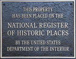
| Added to NRHP | September 29, 2004 |
| Carries |
2 lanes of |
| Crosses | Housatonic River |
| Locale | Sharon and Cornwall, Connecticut |
| Official name | Bridge No. 560 |
| Maintained by | Connecticut Department of Transportation |
| Characteristics | |
| Design | open spandrel concrete arch |
| Total length | 674 feet (205 m) |
| History | |
| Opened | 1930 |
The Cornwall Bridge (also known as Bridge No. 560) is a two-lane, concrete arch bridge carrying U.S. Route 7/Connecticut Route 4 over the Housatonic River and the Housatonic Railroad in Northwestern Connecticut. It was built in 1930 by C.W. Blakeslee and Sons for the Connecticut Highway Department and consists of 6 open-spandrel arches spanning 674 feet (205 m), and is a fairly large example of concrete open-spandrel construction.[2] The bridge was reconstructed in 1994 and was listed on the National Register of Historic Places in 2004.[1]
Description and history
The Cornwall Bridge is located in southwestern Cornwall and southeastern Sharon, near the village known as Cornwall Bridge. It is oriented east-west, principally crossing the south-flowing Housatic River, but also the tracks of the former Housatonic Railroad, which parallels the river's east bank, and roads named River Road on each side. The bridge has six spans of open-spandrel concrete construction, the longest at 180 feet (55 m) spanning the river. The five smaller spans (two on the west bank, three on the east) are each 76 feet (23 m) in length. In addition to the arched portion of the structure, there are three concrete girder approach spans on each side, giving the bridge a total length of 859 feet (262 m). It carries two lanes of traffic, with no sidewalks.[2]
The village on the Cornwall side is called Cornwall Bridge, having been so named because a bridge of some sort has stood here for many years. The present bridge was built in 1930, replacing a covered bridge built in the 19th century. The open spandrel design was chosen to minimize the bridge's footprint and use of concrete, which would have been much more extensive and expensive with more typical designs. It is one of six open-spandrel bridges in the state, and is the largest of those. The bridge was built as part of a state program to modernize the infrastructure of the state's principal travel arteries.[2]
See also

- List of crossings of the Housatonic River
- National Register of Historic Places listings in Litchfield County, Connecticut
- List of bridges on the National Register of Historic Places in Connecticut
References
- 1 2 National Park Service (2009-03-13). "National Register Information System". National Register of Historic Places. National Park Service.
- 1 2 3 "NRHP nomination for Bridge No. 560". National Park Service. Retrieved 2015-01-08.
External links
![]()
Crossings of the Housatonic River | ||||
|---|---|---|---|---|
| ||||
| Topics | |
|---|---|
| Lists by states |
|
| Lists by insular areas | |
| Lists by associated states | |
| Other areas | |
| |