Coreley
| Coreley | |
|---|---|
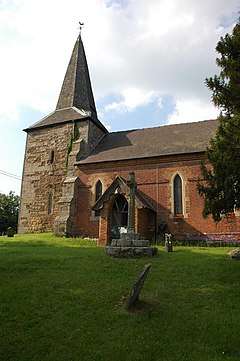 St Peter's church, Coreley | |
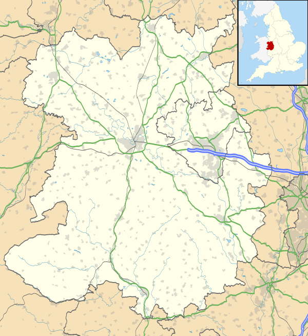 Coreley Coreley shown within Shropshire | |
| Population | 388 (2011)[1] |
| OS grid reference | SO616737 |
| Civil parish |
|
| Unitary authority | |
| Ceremonial county | |
| Region | |
| Country | England |
| Sovereign state | United Kingdom |
| Post town | LUDLOW |
| Postcode district | SY8 |
| Dialling code | 01584 |
| Police | West Mercia |
| Fire | Shropshire |
| Ambulance | West Midlands |
| EU Parliament | West Midlands |
| UK Parliament | |
Coreley is a small, dispersed village and civil parish in south Shropshire, England, near to Clee Hill Village.[2] It is situated approximately 30 miles (48 km) south west of Birmingham and just 4.5 miles (7.2 km) north east of Tenbury Wells.[3] The name Corely comes from the Old English corn meaning a crane/heron and lēah meaning a forest/wood. This translates to crane wood/farmland. [4][5]
CORELEY, a parish in Cleobury-Mortimer district, Salop; under the Clee Hills, 3½ miles NNE of Tenbury r. station, and 5 WSW of Cleobury-Mortimer. Post town, Tenbury. Acres, 2, 175. Rated property, £1, 490. Pop., 515. Houses, 106. The property is divided among a few. The living is a rectory in the diocese of Hereford. Value, £280.* Patron, Rev. J. Burnett Stuart. The church is of brick, and ancient, with tower and spire; and was reported in 1859 as bad.[6][7]
History
Coreley is a very rural parish and historically industry in Coreley has been dominated by agriculture. In 1831 the occupation of men living in Coreley was largely dominated by farmers and agricultural labourers.[8][9] In 1881 industry in Coreley was also engaged in mining which attracted the majority of working males whilst others continued with agricultural practices.[10][11] This contrasts with the more recent 2001 census which states that only 8% of both men and women were working in the agricultural field and mining was no longer represented due to the mining industry being closed down in 1984.[12] The most popular career paths for the population of Coreley, according to 2001 census are: Construction; Health and Social Work and Real Estate.
Listed buildings include Brook Row Cottage, Colliers Arms Public House and Hints Farm, all Grade II.
Transport
Bus Service
The village is near the A4117, along which travels the 292 Kidderminster to Ludlow bus.[13]
Rail Links
The closest station to Coreley is in Ludlow which offers a regular train service to Manchester, Cardiff[14] or to Birmingham via Hereford[15]
Local Businesses
- Cleobury Mortimer Golf Club - The nearby town of Kidderminster offers a premier 27 hole golf facility founded in 1993.[16]
- OTS Electricians[17] - The also nearby town of Ludlow has a locally well-endorsed electricians named OTS which operate across Shropshire
See also
References
- ↑ "Civil Parish population 2011". Retrieved 25 November 2015.
- ↑ "Coreley Facts". 2 May 2011. Retrieved 23 April 2012.
- ↑ "Coreley, Shropshire, UK to Tenbury Wells". Google Maps. Retrieved 27 April 2012.
- ↑ Watts (2004). Cambridge Dictionary of English Place-names. Cambridge University Press. p. 157. Retrieved 2 May 2012.
- ↑ University of Nottingham. "Key to English Place-names". Retrieved 2 May 2012.
- ↑ "History of Coreley". 1872. Retrieved 3 May 2012.
- ↑ The Imperial Gazetteer of England and Wales. 1872. Retrieved 3 May 2012.
- ↑ "Coreley CP/AP through time". Retrieved 27 April 2012.
- ↑ 1831 Census of Great Britain, Abstract of Answers. UK. 1883. Retrieved 2 May 2012.
- ↑ "Coreley CP/AP through time". Retrieved 27 April 2012.
- ↑ 1881 Census of England and Wales, Ages, Table 10, 'Occupations of Males and Females in the Division and its Registration Counties'. UK. 1883. Retrieved 2 May 2012.
- ↑ "Parish of Coreley 2001 Census Profile". Retrieved 2 May 2012.
- ↑ "Cornbrook, Coreley Bus Stop Information". Retrieved 2 May 2012.
- ↑ National Rail. "Departure Board at Ludlow". Retrieved 2 May 2012.
- ↑ "Ludlow to Birmingham train route". Retrieved 2 May 2012.
- ↑ "Cleobury Golf Club". Retrieved 2 May 2012.
- ↑ "OTS". Retrieved 2 May 2012.
External links
![]()
| Unitary authorities | |
|---|---|
| Major settlements | |
| Rivers | |
| Canals | |
| Topics | |