Nimmitabel
| Nimmitabel New South Wales | |||||||||
|---|---|---|---|---|---|---|---|---|---|
 Looking south through the town along the highway | |||||||||
|
Nimmitabel | |||||||||
| Coordinates | 36°30′0″S 149°17′0″E / 36.50000°S 149.28333°ECoordinates: 36°30′0″S 149°17′0″E / 36.50000°S 149.28333°E | ||||||||
| Population | 320 (2016 census)[1] | ||||||||
| Postcode(s) | 2631 | ||||||||
| Elevation | 1,075 m (3,527 ft) | ||||||||
| Location | |||||||||
| LGA(s) | Snowy Monaro Regional Council | ||||||||
| State electorate(s) | Monaro | ||||||||
| Federal Division(s) | Eden-Monaro | ||||||||
| |||||||||
Nimmitabel is a small town in the Monaro region in southeast New South Wales, Australia, in the Snowy Monaro Regional Council local government area. At the 2016 census, Nimmitabel had a population of 320.[1]
The town is 37 kilometres (23 mi) south of Cooma and 75 kilometres (47 mi) west of Bega. Nimmitabel is on a stretch of highway shared between the Snowy Mountains Highway (HWY B72) and the Monaro Highway (HWY B23).
It is on the southern end of the Great Dividing Range, at the west of the Monaro Range, and lies 20 kilometres (12 mi) west of the Wadbilliga National Park.
Nimmitabel means "the place where many waters start or divide" in the local Aboriginal language.[2] Many various spellings were adopted for the town, including: Nimmitybelle, Nimithybale, Nimitybell, Nimity Belle and Nimmitabel.
The area around Nimmitabel has the only true chernozem soil in Australia, a very rich, fertile and dark colored soil.[3]
Climate
Nimmitabel has a subtropical highland influenced (Cwb) oceanic climate (Cfb) with mild to warm summers and cool to cold, snowy winters averaging –2° to 8° C with evenly spread rainfall throughout the year. Frosts occur regularly during autumn, winter and spring. Because of its elevation, several snowfalls can be expected each year from May to September.
| Climate data for Nimmitabel, NSW (Wastewater Treatment Facility); 1,075 m AMSL; 36° 26' 14.28" S | |||||||||||||
|---|---|---|---|---|---|---|---|---|---|---|---|---|---|
| Month | Jan | Feb | Mar | Apr | May | Jun | Jul | Aug | Sep | Oct | Nov | Dec | Year |
| Record high °C (°F) | 37.2 (99) |
38.3 (100.9) |
31.7 (89.1) |
25.6 (78.1) |
23.9 (75) |
17.2 (63) |
14.5 (58.1) |
18.7 (65.7) |
25.6 (78.1) |
26.1 (79) |
31.1 (88) |
34.4 (93.9) |
38.3 (100.9) |
| Average high °C (°F) | 22.8 (73) |
22.6 (72.7) |
20.2 (68.4) |
15.7 (60.3) |
11.6 (52.9) |
8.3 (46.9) |
7.7 (45.9) |
9.4 (48.9) |
12.8 (55) |
16.0 (60.8) |
18.6 (65.5) |
21.6 (70.9) |
15.6 (60.1) |
| Average low °C (°F) | 8.5 (47.3) |
8.9 (48) |
6.7 (44.1) |
3.6 (38.5) |
0.9 (33.6) |
−1.2 (29.8) |
−1.9 (28.6) |
−1.3 (29.7) |
0.7 (33.3) |
3.1 (37.6) |
5.2 (41.4) |
7.4 (45.3) |
3.4 (38.1) |
| Record low °C (°F) | −1.1 (30) |
−1.1 (30) |
−2.1 (28.2) |
−3.3 (26.1) |
−7.2 (19) |
−8.7 (16.3) |
−9.9 (14.2) |
−10.5 (13.1) |
−8.7 (16.3) |
−6.6 (20.1) |
−3.9 (25) |
−2.2 (28) |
−10.5 (13.1) |
| Average precipitation mm (inches) | 68.2 (2.685) |
59.3 (2.335) |
59.5 (2.343) |
48.7 (1.917) |
51.5 (2.028) |
66.9 (2.634) |
50.1 (1.972) |
45.7 (1.799) |
49.1 (1.933) |
58.1 (2.287) |
61.7 (2.429) |
67.7 (2.665) |
686.5 (27.027) |
| Average precipitation days | 7.6 | 7.5 | 7.9 | 7.6 | 8.6 | 9.8 | 9.0 | 9.0 | 9.4 | 9.5 | 9.0 | 8.6 | 103.5 |
| Source: Climate statistics for Australian locations: Nimmitabel | |||||||||||||
History
- 1840 Locals started calling the village Nimoitebool
- 1845 Appears on Townsend's map as Nimmitabel
- 1858 Church was built
- 1857 Renewal of licence for hotel
- 1858 Post office arrives
- 1861 Bell's Store
- 1863 Separate Courthouse built
- 1865 Geldmacher builds windmill
- 1866 Cameron's Store opens
- 1869 Nimmitabel Public School opens
- 1912 Railway arrives
- 1921 Area's first saw-mill opens
- 1959 Used as location for multi-Oscar nominated film The Sundowners[4]
- 1986 Railway closes
Gallery
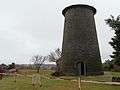 Geldmacher's windmill tower at Nimmitabel
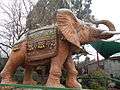 The concrete elephant at the Nimmitabel Bakery
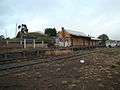 Nimmitabel railway station 21 years after the last train
References
- 1 2 Australian Bureau of Statistics (27 June 2017). "Nimmitabel (State Suburb)". 2016 Census QuickStats. Retrieved 7 July 2017.

- ↑ "Nimmitabel". Geographical Names Register (GNR) of NSW. Geographical Names Board of New South Wales. Retrieved 7 November 2009.
- ↑ KG McQueen "The Tertiary Geology And Geomorphology Of The Monaro: The Perspective In 1994" Centre For Australian Regolith Studies, Canberra 1994
- ↑ "America's Best, Britain's Finest: A Survey of Mixed Movies" - Google Books, John Howard Reid, pub. Lulu.com, March 2006. ISBN 9781411678774, p.241
External links
![]()
- Aerial photo of Nimmitabel from Terraserver
- Information about Nimmitabel, including history and photos
- Some history from Peter Goed, particular focus on the 1950s
- Article: "The Day the Stars Came to Nimmitabel..The Making of the Sundowners" by Peter Goed @ Cooma-Monaro website (includes photos from the making of the film in 1959)