Colinton, New South Wales
| Colinton New South Wales | |||||||||||||||
|---|---|---|---|---|---|---|---|---|---|---|---|---|---|---|---|
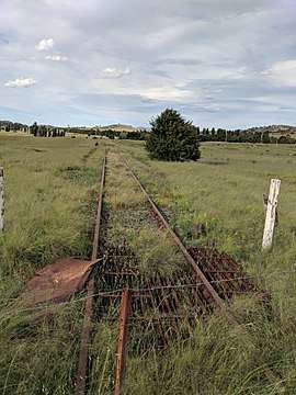 Bombala Railway in Colinton | |||||||||||||||
|
Colinton Location in New South Wales | |||||||||||||||
| Coordinates | 35°51′57″S 149°09′02″E / 35.86583°S 149.15056°ECoordinates: 35°51′57″S 149°09′02″E / 35.86583°S 149.15056°E | ||||||||||||||
| Population | 127 (2016 census)[1] | ||||||||||||||
| Postcode(s) | 2626 | ||||||||||||||
| Location | |||||||||||||||
| LGA(s) | Snowy Monaro Regional Council | ||||||||||||||
| Region | Monaro | ||||||||||||||
| County | Beresford | ||||||||||||||
| Parish | Colinton | ||||||||||||||
| State electorate(s) | Monaro | ||||||||||||||
| Federal Division(s) | Eden-Monaro | ||||||||||||||
| |||||||||||||||
Colinton is a locality in the Snowy Monaro Region, New South Wales, Australia.[2][3] It lies on the eastern side of the Murrumbidgee River and on both sides of the Monaro Highway about 73 km south of Canberra and about 44 km north of Cooma. At the 2016 census, it had a population of 127.[1]
Colinton railway station opened with the extension of the Bombala railway line on 31 May 1889 and closed on 3 September 1975.[4] It had a public school from 1883 to 1938.[5] In the mid twentieth century there was a small settlement at the station, but there is little sign of it now.
References
- 1 2 Australian Bureau of Statistics (27 June 2017). "Colinton". 2016 Census QuickStats. Retrieved 16 August 2017.

- ↑ "Colinton". Geographical Names Register (GNR) of NSW. Geographical Names Board of New South Wales. Retrieved 16 August 2017.
- ↑ "Colinton". OpenStreetMap. Retrieved 16 August 2017.
- ↑ "Colinton station". NSWrail.net. Retrieved 16 August 2017.
- ↑ "Colinton Public School in the School history database search". New South Wales Department of Education. Retrieved 25 December 2017.
This article is issued from
Wikipedia.
The text is licensed under Creative Commons - Attribution - Sharealike.
Additional terms may apply for the media files.