Columbiaville, New York
| Columbiaville, New York | |
|---|---|
| Hamlet | |
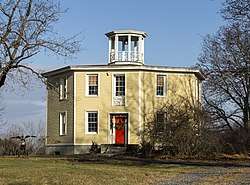 The Octagon House of Columbiaville | |
 Columbiaville, New York  Columbiaville, New York | |
| Coordinates: 42°19′06″N 73°45′11″W / 42.31833°N 73.75306°WCoordinates: 42°19′06″N 73°45′11″W / 42.31833°N 73.75306°W | |
| Country | United States |
| State | New York |
| County | Columbia |
| Elevation | 141 ft (43 m) |
| Time zone | UTC-5 (Eastern (EST)) |
| • Summer (DST) | UTC-4 (EDT) |
| ZIP code | 12050 |
| Area code(s) | 518 & 838 |
| GNIS feature ID | 947196[1] |
Columbiaville is a hamlet in the town of Stockport, Columbia County, New York, United States. The community is located along U.S. Route 9 4.9 miles (7.9 km) north-northeast of Hudson. Columbiaville has a post office with ZIP code 12050, which opened on December 28, 1888.[2][3]
References
![]()
- ↑ "Columbiaville". Geographic Names Information System. United States Geological Survey.
- ↑ United States Postal Service. "USPS - Look Up a ZIP Code". Retrieved August 28, 2017.
- ↑ "Postmaster Finder - Post Offices by ZIP Code". United States Postal Service. Retrieved August 28, 2017.
Municipalities and communities of Columbia County, New York, United States | ||
|---|---|---|
| City | 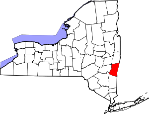 | |
| Towns | ||
| Villages | ||
| CDPs | ||
| Other hamlets | ||
| Footnotes | ‡This populated place also has portions in an adjacent county or counties | |
This article is issued from
Wikipedia.
The text is licensed under Creative Commons - Attribution - Sharealike.
Additional terms may apply for the media files.