Coghlan, Eastern Cape
| Coghlan | |
|---|---|
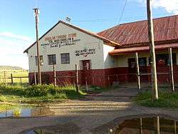 Coghlan Trading Store and Post Office | |
 Coghlan  Coghlan Coghlan (South Africa)  Coghlan Coghlan (Africa) | |
| Coordinates: 31°39′S 28°14′E / 31.650°S 28.233°ECoordinates: 31°39′S 28°14′E / 31.650°S 28.233°E | |
| Country | South Africa |
| Province | Eastern Cape |
| District | Chris Hani |
| Municipality | Engcobo |
| Area[1] | |
| • Total | 1.47 km2 (0.57 sq mi) |
| Population (2001)[1] | |
| • Total | 517 |
| • Density | 350/km2 (910/sq mi) |
| Time zone | UTC+2 (SAST) |
| Postal code (street) | 5054 |
| PO box | 5054 |
Coghlan is a small South African village in the Eastern Cape on the road between Ngcobo and Mthatha and due north from Xuka Drift on the Xuka River.[2] The Xuka River and the Xinika River are the two main tributaries of the Mbashe River.[3]
It has a guest house and village shop.
See also
References
- 1 2 "Sub Place Coghlan". Census 2001.
- ↑ "Xuka Drift, South Africa Atlas-Style Relief Map". Travelpost.com. Archived from the original on 2007-09-27.
- ↑ "Mbashe Catchment Generalised Land-cover". South African Estuaries: Catchment Land Cover. South African Department of Environmental Affairs and Tourism. Archived from the original on 2006-10-08.
External links
Municipalities and communities of Chris Hani District Municipality, Eastern Cape | ||
|---|---|---|
District seat: Queenstown | ||
| Intsika Yethu | .svg.png) | |
| Enoch Mgijima | ||
| Engcobo | ||
| Emalahleni | ||
| Inxuba Yethemba | ||
| Sakhisizwe | ||
This article is issued from
Wikipedia.
The text is licensed under Creative Commons - Attribution - Sharealike.
Additional terms may apply for the media files.