Cockpit Country
| Cockpit Country | |
|---|---|
| Geographical Region | |
 | |
 Cockpit Country | |
| Coordinates: 18°17′43″N 77°41′43″W / 18.295209°N 77.695313°W | |
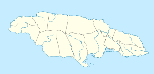
| Country | Jamaica |
| Parish | Trelawny |
| Named for | Topology reminiscent of the shape of cock fighting dens. |
| Time zone | UTC-5 (EST) |
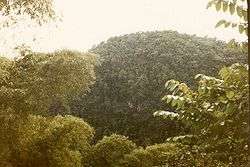
Cockpit Country is an area in Trelawny and Saint Elizabeth parishes in Jamaica. The land is marked by steep-sided hollows, as much as 120 metres (390 ft) deep in places, which are separated by conical hills and ridges. Maroons who had escaped from plantations used the difficult territory for its natural defenses to develop communities outside the control of Spanish or British colonists. Since 1739 it has been the center of Accompong, an indigenous Maroon community that still has a certain recognized autonomy under the independent Jamaican government.
Geography
On the north, the main defining feature is the fault-based "Escarpment", a long ridge that extends from Flagstaff in the west, through Windsor in the centre, to Campbells and the start of the Barbecue Bottom Road (B10). The Barbecue Bottom Road, which runs north-south, high along the side of a deep, fault-based valley in the east, is the only drivable route across the Cockpit Country. Walkers and riders can use two old, historical trails cross further west, the Troy Trail, and the Quick Step Trail. As of 2006 they are seldom used and difficult to find.
In the southwest, near Quick Step, is the district known as the "Land of Look Behind." It was so named because Spanish horsemen venturing into this region of hostile escaped slaves were said to have ridden two to a mount, one rider facing to the rear to keep a precautionary watch against ambush.
Where the ridges between sinkholes in the plateau area have dissolved, flat-bottomed basins or valleys have been formed that are filled with terra rosa soils, some of the most productive on the island. The largest basin is the Vale of Clarendon, 80 kilometres (50 mi) long and 32 kilometres (20 mi) wide. Queen of Spains Valley, Nassau Valley, and Cave Valley were formed by the same process.
Shallow caves, known locally as cockpits (based on pits used for cockfights), are particularly common around the hamlet of Quick Step, reaching a density of 15 per km2.[1] Noteworthy caves include Marta Tick Cave[2] and Minocal's Glory Hole[3]. Ecotourism has been proposed for the hamlet of Quick Step, at the end of the road into the heart of Cockpit County.[4]
Environment
The Cockpit Country is Jamaica's largest remaining contiguous rainforest. In 1979 an unpublished paper proposed preserving the area as a National Park.[5] In 1994 the geographer Alan Eyre[6] proposed that the Cockpit Country be designated as a World Heritage Site to preserve its environment. A petition for protection of the area was submitted to Prime Minister Bruce Golding in 2006.
As of April 2013, public consultations have begun on the definition of the boundary proposed in a recently released study by Mitchell, Miller, Ganapathy, and Spence of the University of the West Indies (UWI).
Eleutherodactylus sisyphodemus, a small, critically endangered frog species, is known only from the Cockpit Country.[7][8] Cockpit Country hosts 90% of the global population of black-billed amazon, a parrot endemic to Jamaica.[9]
Cockpit Country is also home to the Jamaican Swallowtail, the largest butterfly in the Western hemisphere. Cockpit Country is one of the last remaining homes for the species.
See also
References
- ↑ Jamaica Underground: The Caves, Sinkholes and Underground Rivers of the Island, by Alan Fincham (page 31).
- ↑ http://www.jamaicancaves.org/martatick.htm
- ↑ http://www.jamaicancaves.org/minocals_050115.htm
- ↑ http://www.cockpitcountry.com/Quickstep.html
- ↑ Cotterell "The Proposed Development of the Cockpit Country." Unpublished. NRCD, Kingston, Jamaica. 1979.
- ↑ Eyre, Slow Death of a Tropical Rainforest: The Cockpit Country of Jamaica, West Indies, 1994
- ↑ Hedges, B.; Koenig, S. & Wilson, B. (2004). "Eleutherodactylus sisyphodemus". The IUCN Red List of Threatened Species. IUCN. 2004: e.T7148A12831445. doi:10.2305/IUCN.UK.2004.RLTS.T7148A12831445.en. Retrieved 10 January 2018.
- ↑ Frost, Darrel R. (2015). "Eleutherodactylus sisyphodemus Crombie, 1977". Amphibian Species of the World: an Online Reference. Version 6.0. American Museum of Natural History. Retrieved 18 April 2015.
- ↑ BirdLife International (2013). "Amazona agilis". IUCN Red List of Threatened Species. Version 2013.2. International Union for Conservation of Nature. Retrieved 26 November 2013.
External links
| Wikimedia Commons has media related to Cockpit Country. |
Coordinates: 18°17′43″N 77°41′43″W / 18.2952094°N 77.6953125°W