List of maps of Jamaica
A list of maps of Jamaica in chronological order.
1494-1949
| K#[1] | Date | Title | Carto- grapher | Description | |
|---|---|---|---|---|---|
| 1 | 1528 | Map of Jamaica | Benedetto Bordone | A very simple map of Jamaica from Bordone's Isolario (The Book of Islands), printed in Venice in 1528. |  |
| 2 | 1562 | Isloa Cuba Nova | Girolamo Ruscelli | Fragment showing Jamaica from an early map of Cuba in Ruscelli's Atlas, probably the 1562 edition, published in Italy.[2] | .png) |
| 4 | 1572 | Jamaica | Tomaso Porcacchi | Early map of Jamaica (and part of Cuba) engraved by Girolamo Porro for Porcacchi's book L'Isole piu Famose del Mondo, first published in Venice in 1572.[3] | .jpg) |
| 8 | 1631 | Map of the Caribbean | Gerardus Mercator(?) | Fragment showing Jamaica from map of Cuba, Puerto Rico, Jamaica, Hispaniola and S Margarita Island (off the coast of Venezuela) in the first Cloppenburgh edition of the large-format Mercator-Hondius Atlas Minor, published in Amsterdam, 1630.[4] | .png) |
| 13 | 1671 | Novissima et Accura-tissima Jamaicae Descriptio | John Ogilby | Engraved by F Lamb, includes a table showing plantations, precincts and settlements on the island.[5] | 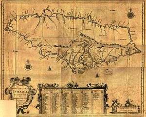 |
| 17 | 1671 | A new and exact map of the isle of Jamaica | Richard Bloome |  | |
| 22 | 1676 | Jamaica and Barbados | John Speed | Top half of a hand tinted map of Jamaica and Barbados printed by Thomas Basset and Richard Chiswell, London, England. On the reverse there is a description of the two islands.[6] | .jpg) |
| 26 | 1680 | Jamaica | Nicolaes Visscher II | .jpg) | |
| 1683 | de Cuba et de Iamaica | Alain Manesson Mallet | An extract showing Jamaica from an engraving in Mallet's Description de L'Univers published by Thierry, Paris, 1683.[7] | .png) | |
| 1684 | A New and Exact Mapp of the Island of Jamaica | Charles Bochart and Humphrey Knollis[8] | |||
| 24 | 1688 | Insula Jamaica | Robert Morden | ||
| 49 | 1710 | Neiuwe Kaart van het Eyland Jamaica | Hermann Moll | ||
| 1711 | Jamaica | ||||
| 1715 | A New Map of the English Empire in the Ocean of America or West Indies | John Senex | |||
| 1717 | A New Map of the Island of Jamaica | Herman Moll | |||
| 54 | 1720 | The island of Jamaica divided into its principal parishes... | Herman Moll | ||
| 1728 | The Island of Jamaica | Herman Moll | |||
| 1730 | Dominia Anglorum præcipuis in Insulis Americæ | Homann's Heirs | |||
| 65 | 1744 | A New and Accurate Map of the Island of Jamaica | Emanuel Bowen | ||
| 64 | 1746 | La Jamaique | Sieur le Rouge | ||
| 66 | 1753 | Carte de l'Isle de Jamaique | Jacques-Nicolas Bellin | ||
| 71 | 1755 | A new map of Jamaica ... from actual surveys made ... from the year 1730 to 1749[8] | Patrick Browne | ||
| 1757 | A Correct Map of Jamaica | Georg Dionysius Ehret | |||
| 77 | 1758 | Carte de l'Isle de Jamaique | Jacques-Nicolas Bellin | ||
| 76 | 1758 | Carte Particularie De L’ Isle De La Jamaique | Jacques-Nicolas Bellin | ||
| 1760 | A Correct Map of Jamaica | ||||
| 83 | 1762 | A Correct Map of the Island of Jamaica | John Gibson | ||
| 89 | 1765 | A New Map of the Island of Jamaica | Thomas Kitchin | ||
| 101 | 1775 | Jamaica | Thomas Jeffreys | ||
| 104 | 1779 | La Giammaica | Antonio Zatta | ||
| 105 | 1780 | Carte de l'Isle de la Jamaique | Rigobert Bonne | ||
| 131 | 1794 | A Map of the Island of Jamaica | Bryan Edwards | ||
| 141 | 1805 | Charte von Jamaica | Jean Baptiste Marie George Bory de Saint Vincent | ||
| 1812 | Isle de la Jamaique | Arrowsmith | |||
| 145 | 1814 | Jamaica | John Thomson | ||
| 150 | 1822 | Geographical, Statistical, and Historical Map of Jamaica | Carrey & Lea | ||
| 151 | 1823 | Jamaica | Fielding Lucas | ||
| 152 | 1825 | Jamaique | J A Buchon | ||
| 1835 | The British Island in the West Indies | Society for the Diffusion of Useful Knowledge | |||
| 1836 | Jamaica | J & C Walker | |||
| 1850 | Tourist Map of the Island of Jamaica | Edward Vincent D'Invilliers | |||
| 1851 | Jamaica | J Rapkin / J Tallis | |||
| 1854 | Jamaica | Harvey Newcomb | |||
| 1859 | Map of Haiti and Jamaica | Edward Weller | |||
| 1860 | Island of Jamaica | Fullarton | |||
| 1880 | General Chart of the Island of Jamaica | John Purdy | |||
| 1882 | Outline Map of Jamaica | Dangerfield | |||
| 1892 | Cuba and Jamaica | D Appleton & Co | |||
| 1903 | Jamaica | Dodd, Mead and Company | |||
| 1908 | Jamaica Earthquake | Vaughn Cornish | |||
| 1910 | Jamaica | Cram | |||
1950-1979
The 1:50,000 series
Between the early 1950s and the late 1970s the UK Directorate of Overseas Surveys published several editions of a series of maps of Jamaica at the scale of 1:50,000. The following table summarises the known publication dates.
| Sheet | First Edition | Second Edition | Third Edition |
|---|---|---|---|
| Sheet A | 1959 | ||
| Sheet B | 1958 | ||
| Sheet C | 1959 (reprinted 1973) | ||
| Sheet D | 1959 (reprinted 1974) | ||
| Sheet E | 1958 (reprinted 1974) | ||
| Sheet F | 1958 (reprinted 1974) | ||
| Sheet G | 1973 | ||
| Sheet H | 1973 (reprinted 1974) | ||
| Sheet K | 1970 (reprinted 1974) | ||
| Sheet L | 1954 | 1966 (reprinted 1973) | |
| Sheet M | 1967 (reprinted 1973) | ||
| Sheet N | 1967 (reprinted 1971) | ||

Index to the 1:50,000 maps of Jamaica published by the UK Directorate of Overseas Surveys from the early 1950s on.
Others
| K#[1] | Date | Title | Cartographer | Description |
|---|---|---|---|---|
| 1967 | Jamaica Road Map | Esso | ||
| 1972 | Jamaica Road Map | Texaco | ||
Town plans
Kingston
| Date | Title | Carto- grapher | Description | |
|---|---|---|---|---|
| 1891-06 | Kingston and environs | War Office | A lithograph published by Edward Stanford for the Intelligence Division of the War Office. It was based on earlier maps and Admiralty charts, updated with the observations of five army officers. The illustration shows an extract depicting Kingston Harbour.[9] | .png) |
Montego Bay
- Petrol company road maps
- Esso, 1967, on reverse
- Texaco, 1972, on reverse
Spanish Town
- Petrol company road maps
- Esso, 1967, on reverse
- Texaco, 1972, on reverse
Mandeville
- Petrol company road maps
- Esso, 1967, on reverse
- Texaco, 1972, on reverse
Bibliography
- Higman, B W & Hudson, B J (2009). "Place names and history". Jamaican Place Names. Mona, Jamaica: University of the West Indies Press. pp. 13–18. ISBN 978-976-640-217-4.
- Kapp, Kit S (1968). "The Printed Maps of Jamaica up to 1825". Kingston, Jamaica: Bolivar Press.
References
- 1 2 Kapp, Captain Kit S (1968). "The Printed Maps of Jamaica up to 1825". Map Collectors' Series. London: Map Collectors' Circle. 5 (42). Retrieved 2013-10-30.
- ↑ "Archived copy". Archived from the original on 2009-10-01. Retrieved 2009-09-26.
- ↑ "Archived copy". Archived from the original on 2009-10-01. Retrieved 2009-09-22.
- ↑ "Archived copy". Archived from the original on 2009-10-01. Retrieved 2009-09-26.
- ↑ "Archived copy". Archived from the original on 2012-02-22. Retrieved 2015-05-21.
- ↑ "Archived copy". Archived from the original on 2009-10-01. Retrieved 2009-10-24.
- ↑ "Archived copy". Archived from the original on 2009-10-01. Retrieved 2009-10-24.
- 1 2 Higman 2009, p. 279
- ↑ "Jonathan Potter". Retrieved 18 October 2014.
This article is issued from
Wikipedia.
The text is licensed under Creative Commons - Attribution - Sharealike.
Additional terms may apply for the media files.