Rio Minho
| Rio Minho | |
|---|---|
 | |
| Country | Jamaica |
| Physical characteristics | |
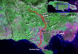
| Main source | Dry Harbour Mountains which form part of Cockpit Country of Jamaica |
| River mouth | Portland Point in Clarendon |
| Length | 92.8 km (57.7 mi) |
| Basin features | |
| Basin size | 1,700 km2 (660 sq mi) |
The Rio Minho is the longest river in Jamaica at 92.8 kilometres (57.7 mi).[1] It rises close to the island's geographic centre, flows generally south-southwest and reaches the Caribbean Sea at Carlisle Bay in the central south coast, to the west of the island's southernmost point, Portland Point.
The town of May Pen, Clarendon lies on the banks of the river.
References
This article is issued from
Wikipedia.
The text is licensed under Creative Commons - Attribution - Sharealike.
Additional terms may apply for the media files.