Clifton Aqueduct
| Clifton Aqueduct | |
|---|---|
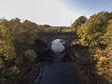 The aqueduct spanning the Irwell, as viewed from the Clifton Viaduct downstream | |
| Coordinates | 53°31′40″N 2°19′02″W / 53.5277°N 2.3172°WCoordinates: 53°31′40″N 2°19′02″W / 53.5277°N 2.3172°W |
| OS grid reference | |
| Carries | Manchester, Bolton and Bury Canal |
| Crosses | River Irwell |
| Locale | Clifton, Greater Manchester |
| Heritage status | Grade II |
| Characteristics | |
| Trough construction | Stone |
| Pier construction | Brick |
| Towpaths | Both |
| No. of spans | Three |
| History | |
| Designer | Charles Roberts and John Nightingale |
| Construction end | 1796 |
Clifton Aqueduct, built in 1796, carried the Manchester, Bolton and Bury Canal across the River Irwell in Clifton, near Manchester, England. It is preserved as a Grade II listed structure.[1] The aqueduct is constructed of dressed stone with brick arches. Three segmental arches with keystones rest on triangular-ended cutwaters. Above the cutwaters are flat Pilasters. A C20 brick parapet remains on the eastern side. There is a towpath on each side, and the aqueduct contains grooves for stop planks to be inserted, to drain the canal.[1] The aqueduct was engineered by Charles Roberts and John Nightingale.
The aqueduct is one of two remaining along the canal route, the other being Prestolee Aqueduct. The canal is undergoing restoration and is hoped to be in operation around 2020.
As of 2011, the aqueduct is currently not in water.
Rail Access
The nearest station is Clifton (Manchester) railway station.
See also
References
- 1 2 Historic England. "Clifton Aqueduct (211968)". Images of England. Retrieved 2008-06-27.
External links
- Clifton Aqueduct on Pennine Waterways website
- Clifton Aqueduct, Manchester, Bury & Bolton canal website
- Historic England. "Details from image database (211968)". Images of England.
Buildings and structures in the City of Salford, England | ||
|---|---|---|
Italics denote building under construction | ||
| Highrises (over 50 metres) |     | |
| Notable lowrises |
| |
| Places of Worship | ||
| Transportation | ||
| Shopping centres | ||
| Sports and entertainment |
| |
| Memorials | ||
| Bridges | ||
| Lists | ||
| Listed buildings in | ||