Prestolee Aqueduct
| Prestolee Aqueduct | |
|---|---|
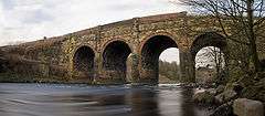 Panorama of Prestolee Aqueduct | |
| Coordinates | 53°33′09″N 2°22′35″W / 53.5525°N 2.3764°WCoordinates: 53°33′09″N 2°22′35″W / 53.5525°N 2.3764°W |
| OS grid reference | |
| Carries | Manchester, Bolton and Bury Canal |
| Crosses | River Irwell |
| Locale | Prestolee, Greater Manchester |
| Heritage status | Grade II |
| Characteristics | |
| Trough construction | Stone |
| Pier construction | Stone |
| Total length | 185 feet (56.4 m) |
| Width | 16 feet 6 inches (5.03 m) |
| Traversable? | Yes |
| Towpaths | SW Side |
| No. of spans | Four |
| History | |
| Construction end | 1793 |
Prestolee Aqueduct is a stone-built aqueduct in Prestolee, Kearsley in the Metropolitan Borough of Bolton, Greater Manchester, England. The four-arch structure was constructed in 1793 to carry the Manchester, Bolton and Bury Canal across the River Irwell. It is now preserved as a Grade II listed building.[1]
The aqueduct is one of two remaining major structures on the canal, the other being the Clifton Aqueduct. A third major aqueduct, Damside Aqueduct, was demolished in the 1950s.
As of 2007, the aqueduct still carried water, although it was not navigable as adjoining sections of the canal are in need of restoration.

The Bolton arm of the canal runs underneath the house at the very top of this image, and is accessed via a set of locks
See also
References
- ↑ Historic England. "Prestolee Aqueduct (210525)". Images of England. Retrieved 2008-06-27.
External links
Buildings and structures in the Metropolitan Borough of Bolton, England | ||
|---|---|---|
| Buildings |  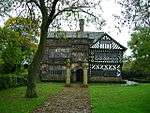  | |
| Places of worship | ||
| Education | ||
| Transportation | ||
| Shopping complexes | ||
| Sport and Entertainment | ||
| Bridges | ||
| Others | ||
| Demolished | ||
| Lists | ||
| Listed buildings in | ||
This article is issued from
Wikipedia.
The text is licensed under Creative Commons - Attribution - Sharealike.
Additional terms may apply for the media files.