Cleveland/Bradley County Greenway
| Cleveland/Bradley County Greenway | |
|---|---|
|
Official logo. | |
| Length | 4 miles[1] |
| Location | Cleveland, Bradley County, Tennessee |
| Established | 2001 |
| Trailheads | Willow Street, north of Mohawk Drive |
| Use | Walking, bicycling |
| Hiking details | |
| Surface | Concrete, Asphalt |
| Maintained by | Greenway Advisory Board |
| Website |
cbcgreenway |
The Cleveland/Bradley County Greenway is a 4-mile-long public greenway walking path in Cleveland, Tennessee maintained by the local Greenway Advisory Board. The path is the longest path in the Greenway Network, a network of public walking trails located in Bradley County, Tennessee.[2]
Description
The Cleveland/Bradley County Greenway weaves through the northern part of Cleveland from Willow Street to Mohawk Drive. The path follows South Mouse Creek its entire length and crosses the waterway in four locations. Approximately two-thirds of the greenway is concrete and the remainder is asphalt. It has a total of nine accesspoints. The trail begins at a gated intersection with Willow Street, travelling north through a wooded residential area. Approximately 300 yards later, it crosses Mouse Creek, and runs parallel just feet from the U.S. Route 11 Bypass (Keith Street). Less than 200 yards later the Greenway and Mouse Creek together pass underneath 17th Street, and 20th Street approximately 1/4 mile later. Approximately 300 yards later, the Greenway crosses Mouse Creek again, and enters a wooded area once again. The Greenway passes the international offices of the Church of God and Church of God in Cleveland, Tennessee, and approximately 0.4 miles later, the greenway and Mouse Creek pass underneath State Route 60 (25th Street). The greenway makes a slight curve to the northeast, and passes through a commercial and residential area, before crossing Mouse Creek again and passing underneath Keith Street about 50 yards later. The greenway then passes an area that has come to be known as Greenway Park, which contains a playground, pavilion, stage, and kiosk, and about 250 yards later passes underneath Raider Drive. The greenway passes alongside Cleveland High School, and about 300 yards later crosses Mouse Creek again. The greenway enters a wooded area, and about 0.6 miles later enters Tinsley Park, and turns sharp to the northeast. About 1/4 mile later, the greenway turns sharp north again and crosses Mouse Creek. It then passes under Mouse Creek Road, and turns northwest, entering a wooded area near commercial and industrial development. The greenway then makes a slight turn to the northeast and about 0.4 miles later passes underneath Paul Huff Parkway. The greenway makes another slight turn to the northeast, and passes under Mohawk Drive approximately 1/4 mile later. The greenway then enters a wooded residential area and comes to an intersection with a connector to a neighborhood, before turning northeast and reaching its northern terminus a little over 100 yards later at a dead end.[3][1]
| Phase | Location | Length |
|---|---|---|
| Phase 1 | 0.57 miles | 25th to 20th Street |
| Phase 2 | 0.8 miles | Raider Drive to 25th Street |
| Phase 3 | 0.51 miles | 20th to Willow Street |
| Phase 4 | 0.75 miles | Mohawk Drive to Tinsley Park |
| Phase 5 | 1.17 miles | Tinsley Park to Raider Drive |
| Phase 6 (under construction) | 0.44 miles | Willow Street to Inman Street |
Leadership and governing
The Greenway is operated by the Greenway Advisory Board, composed of city and county leaders, some of whom are appointed by the Bradley County Commission, Cleveland City Council, Cleveland/Bradley Chamber of Commerce, and Cleveland Utilities.[4] The current chairman is Cameron Fisher.[5] The Advisory Board oversees two subcommittees. Friends of the Greenway is a group that works to promote the Greenway through events and activities.[6] The Greenway Public Arts Committee (GPAC) is a volunteer group that works to provide opportunities for cultural and artistic expressions on the greenway with the intent of enhancing outdoor experiences through public art.[7]
History
The Greenway began as a vision of a few citizens intent on improving the quality of life in the community.[8] Between 1998 and 2001, grants and land donations were accepted from several local businesses to fund the construction.[8] The first phase was completed in October 2001.[9] This was the only section of the greenway open for several years.[9] Phase two was built in 2005, opening on August 3 of that year.[9][10] An approximately 1/4 mile section of phase four, located between Paul Huff Parkway and Mohawk Drive, was built in 2006, while at the same time, work began on the southern part.[9] Phase three was built between August 8, 2007 and May 15, 2008, funded in part through a Tennessee Department of Transportation (TDOT) enhancement grant.[9] Construction on phase four began in September 2008, and the first part was completed in February 2009.[10] The entirety of phase four was completed on December 14, 2010.[10] Construction began on the final planned section, phase five, on June 15, 2011, and was completed in May 2012, eleven years after the beginning of the first section.[10] This was partly funded through a grant from the Tennessee Department of Environment and Conservation (TDEC),[11] and part of this section takes the place of a pre-existing trail in Tinsley Park.[3]
An extension was built from the north end in the summer of 2013 to connect to a nearby neighborhood.[9] The park located between Raider Drive and Keith Street was officially named Greenway Park in January 2015, and is maintained separately by the Cleveland Parks and Recreation Department.[12][10] A stage was completed in the park in June of that year.[13] This was a response to continued acts of vandalism on the greenway.[14]
In July 2015 the Cleveland City Council passed an ordinance to ban juveniles from the greenway between 11 PM and 6 AM unless accompanied by an adult and to install security cameras.[15]
In 2016, a project to extend the trail to the Village Green Town Center, a business and retail shopping center, began. In June 2017, a project to construct an approximately 0.8 mile long connector from Tinsley Park to U.S. Route 11 (North Ocoee Street) began. It will be named the Casteel Connector in honor of a former city manager of Cleveland who pushed for its construction.[16] This project had been in the works since 2012, and was funded partly through a grant from TDOT.[17] [18]
Future plans include expanding the trail to the Hiwassee River in Charleston.[19]
Gallery
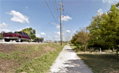 Along Keith Street near 17th Street.
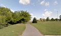 Phase One, the oldest section of the Greenway.
 Bridge over Mouse Creek.
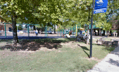 Greenway Park
 Tinsley Park.
External links
References
- 1 2 "Cleveland/Bradley County Greenway". traillink.com. traillink.com. 2012. Retrieved 10 January 2014.
- ↑ "Spurs/Network". cbcgreenway.com. Greenway Advisory Board. 2015. Retrieved November 28, 2017.
- 1 2 Google (7 November 2017). "Overview of Cleveland/Bradley County Greenway" (Map). Google Maps. Google. Retrieved 7 November 2017.
- ↑ "Greenway Advisory Board". clevelandtn.gov. Cleveland Chamber of Commerce. 2016. Retrieved November 28, 2017.
- ↑ Harris, Elmer (July 6, 2016). "Dayton's Greenway Project: A Look into the Future". The Rhea Review. Dayton, Tennessee. Retrieved November 28, 2017.
- ↑ "Leadership". cbcgreenway.com. Greenway Advisory Board. Retrieved November 28, 2017.
- ↑ "New Greenway Public Art". clevelandtn.gov. Cleveland Chamber of Commerce. November 28, 2017. Retrieved November 28, 2017.
- 1 2 "Home". cbcgreenway.com. Greenway Advisory Board. 2013. Archived from the original on January 4, 2014. Retrieved January 10, 2014.
- 1 2 3 4 5 6 "Historical Timeline". cbcgreenway.com. Greenway Advisory Board. 2014. Retrieved January 10, 2014.
- 1 2 3 4 5 "Chronological Highlights". cbcgreenway.com. Greenway Advisory Board. 2017. Retrieved November 28, 2017.
- ↑ "Cleveland/Bradley County Greenway". Bradleyco.net. Cleveland/Bradley County Chamber of Commerce. February 4, 2008. Missing or empty
|url=(help);|access-date=requires|url=(help) - ↑ Love, Joyanna (February 17, 2015). "Greenway projects are set to sprout like spring". Cleveland Daily Banner. Retrieved November 28, 2017.
- ↑ Love, Joyanna (June 13, 2015). "Greenway Park stage completed". Cleveland Daily Banner. Retrieved November 28, 2017.
- ↑ Leach, Paul (July 27, 2015). "Security cameras on the table for Cleveland greenway". Chattanooga Times Free Press. Chattanooga,Tennessee. Retrieved 2018-07-17.
- ↑ Leach, Paul (July 30, 2015). "Juvenile curfew posted on Cleveland greenway". Chattanooga Times Free Press. Chattanooga, Tennessee. Retrieved 2018-07-17.
- ↑ "Cleveland Breaks Ground For New Casteel Connector". The Chattanoogan. Chattanooga, Tennessee. June 7, 2017. Retrieved November 28, 2017.
- ↑ "Bradley Co. City of Cleveland Draft Section 4 Public Notice May 2015" (PDF). tn.gov. Tennessee Department of Transportation. May 2015. Archived from the original (PDF) on December 1, 2017. Retrieved November 28, 2017.
- ↑ "Haslam Announces TDEC, TDOT Grants For Cleveland". Tennessee Office of the Governor. Nashville, Tennessee. July 11, 2013. Archived from the original on December 1, 2017. Retrieved November 28, 2017.
- ↑ Higgins, Randall (November 10, 2011). "Expansion planned for popular Cleveland/Bradley County greenway". Chattanooga Times Free Press. Chattanooga, Tennessee. Retrieved November 28, 2017.