Clawson, Michigan
| Clawson, Michigan | |
|---|---|
| City | |
| Motto(s): "Little City with a Big Heart"[1] | |
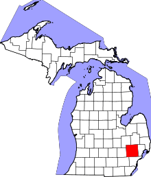
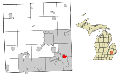 Location in the state of Michigan | |
 Clawson, Michigan Location within the state of Michigan | |
| Coordinates: 42°32′00″N 83°08′47″W / 42.53333°N 83.14639°WCoordinates: 42°32′00″N 83°08′47″W / 42.53333°N 83.14639°W | |
| Country | United States |
| State | Michigan |
| County | Oakland |
| Government | |
| • Type | Council-Manager |
| • Mayor | Deborah wooley |
| • City Manager | Mark Pollock |
| Area[2] | |
| • City | 2.20 sq mi (5.70 km2) |
| • Land | 2.20 sq mi (5.70 km2) |
| • Water | 0 sq mi (0 km2) |
| Elevation | 663 ft (202 m) |
| Population (2010)[3] | |
| • City | 11,825 |
| • Estimate (2017)[4] | 11,946 |
| • Density | 5,400/sq mi (2,100/km2) |
| • Metro | 4,296,250 |
| Time zone | UTC-5 (EST) |
| • Summer (DST) | UTC-4 (EDT) |
| ZIP codes | 48017, 48398 |
| Area code(s) | 248 |
| FIPS code | 26-16160[5] |
| GNIS feature ID | 0623389[6] |
| Website | City of Clawson, Michigan |
Clawson is a city in Oakland County in the U.S. state of Michigan. It is part of the Detroit metropolitan area. At the 2010 census, its population was 11,825.[7]
History
The city's name is a misspelling of John Lawson's name, a local settler.[8] Clawson began in 1829 and was originally known as Pumachug and The Corners. It was incorporated in 1921 as a village and in 1940 as a city.[9]
Geography
According to the United States Census Bureau, the city has a total area of 2.20 square miles (5.70 km2), all land.[2]
Demographics
| Historical population | |||
|---|---|---|---|
| Census | Pop. | %± | |
| 1930 | 3,377 | — | |
| 1940 | 4,006 | 18.6% | |
| 1950 | 5,196 | 29.7% | |
| 1960 | 14,795 | 184.7% | |
| 1970 | 17,617 | 19.1% | |
| 1980 | 15,103 | −14.3% | |
| 1990 | 13,874 | −8.1% | |
| 2000 | 12,732 | −8.2% | |
| 2010 | 11,825 | −7.1% | |
| Est. 2017 | 11,946 | [4] | 1.0% |
| U.S. Decennial Census[10] | |||
2010 census
At the 2010 census,[3] there were 11,825 people, 5,460 households and 2,992 families residing in the city. The population density was 5,375.0 inhabitants per square mile (2,075.3/km2). There were 5,791 housing units at an average density of 2,632.3 per square mile (1,016.3/km2). The racial makeup was 93.4% White, 1.9% African American, 0.3% Native American, 2.0% Asian, 0.4% from other races, and 1.9% from two or more races. Hispanic or Latino of any race were 2.1% of the population.
There were 5,460 households of which 23.5% had children under the age of 18 living with them, 41.8% were married couples living together, 8.9% had a female householder with no husband present, 4.1% had a male householder with no wife present, and 45.2% were non-families. 38.2% of all households were made up of individuals and 11.8% had someone living alone who was 65 years of age or older. The average household size was 2.14 and the average family size was 2.88.
The median age was 39.9 years. 17.9% of residents were under the age of 18; 7.6% were between the ages of 18 and 24; 31.4% were from 25 to 44; 28.4% were from 45 to 64; and 14.8% were 65 years of age or older. The sex makeup was 49.0% male and 51.0% female.
2000 census
At the 2000 census,[5] there were 12,732 people, 5,572 households and 3,259 families residing in the city. The population density was 5,787.0 per square mile (2,234.5/km²). There were 5,676 housing units at an average density of 2,579.9 per square mile (996.1/km²). The racial makeup was 96.10% White, 0.80% African American, 0.34% Native American, 1.32% Asian, 0.25% from other races, and 1.19% from two or more races. Hispanic and Latino of any race were 1.14% of the population.
There were 5,572 households of which 25.1% had children under the age of 18 living with them, 46.8% were married couples living together, 8.9% had a female householder with no husband present, and 41.5% were non-families. 35.2% of all households were made up of individuals and 12.5% had someone living alone who was 65 years of age or older. The average household size was 2.26 and the average family size was 2.98.
20.6% of the population were under the age of 18, 7.5% from 18 to 24, 34.8% from 25 to 44, 21.9% from 45 to 64, and 15.2% who were 65 years of age or older. The median age was 38 years. For every 100 females, there were 94.0 males. For every 100 females age 18 and over, there were 89.5 males.
The median household income was $50,929 and the median family income was $64,684. Males had a median income of $45,242 and females $30,679. The per capita income was $25,676. About 1.4% of families and 3.5% of the population were below the poverty line, including 1.6% of those under age 18 and 4.8% of those age 65 or over.
Government
Clawson utilizes the Council-Manager form of government, and thus is governed by a City Council consisting of a Mayor and four council members. The city council appoints a City Manager, who manages the day-to-day operations of the city.
Clawson is represented in the State House of Representatives by Martin Howrylak, in the State Senate by Marty Knollenberg, in the US Congress 9th Congressional District by Sander M. Levin, and in the US Congress 11th Congressional District by David Trott.
Education
The city of Clawson is entirely within the boundaries of Clawson Public Schools.
Japhet School, a private school, is located in a former YWCA building in Clawson. It moved there in August 2013 from its previous location in Madison Heights.[11]
Notable people
- Mark Campbell, tight end for the New Orleans Saints
- Tim Gleason, defenseman for the Toronto Maple Leafs; 2010 Olympian, ice hockey
- Jon Jansen, offensive tackle for the Washington Redskins
- David Robert Mitchell (born 1974), American film director
- Dan Scanlon, director at Pixar Animation Studios
References
- ↑ "City of Clawson, Michigan". City of Clawson, Michigan. Retrieved August 24, 2012.
- 1 2 "US Gazetteer files 2010". United States Census Bureau. Archived from the original on January 24, 2012. Retrieved November 25, 2012.
- 1 2 "American FactFinder". United States Census Bureau. Retrieved 2012-11-25.
- 1 2 "American FactFinder". Retrieved June 18, 2018.
- 1 2 "American FactFinder". United States Census Bureau. Archived from the original on 2013-09-11. Retrieved 2008-01-31.
- ↑ U.S. Geological Survey Geographic Names Information System: Clawson, Michigan
- ↑ "Race, Hispanic or Latino, Age, and Housing Occupancy: 2010 Census Redistricting Data (Public Law 94-171) Summary File (QT-PL), Clawson city, Michigan". U.S. Census Bureau, American FactFinder 2. Archived from the original on September 11, 2013. Retrieved August 18, 2011.
- ↑ "Profile for Clawson, Michigan, MI". ePodunk. Retrieved August 24, 2012.
- ↑ Walter Romig, Michigan Place Names, p. 119
- ↑ "Census of Population and Housing". Census.gov. Archived from the original on May 12, 2015. Retrieved June 4, 2015.
- ↑ "Japhet School Celebrates 40 Years and Moves to Clawson." Japhet School. July 9, 2013. Retrieved on November 6, 2013. (Archive) "31202 Dorchester, Madison Heights, MI 48701" "Mailing address through August 20: above" and "Mailing address after August 20: 839 S. Crooks, Clawson, MI 48017"
External links
- City of Clawson official website
- Clawson School District
- Clawson Historical Museum
- Transcript from the 2007 State of the City address
- Article about local mayoral / council race, current as of 11/2007