Lathrup Village, Michigan
| Lathrup Village | |
|---|---|
| City | |
| City of Lathrup Village | |
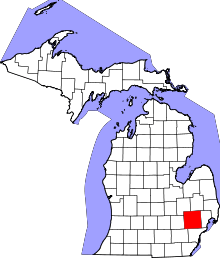
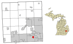 Location of Lathrup Village, Michigan | |
| Coordinates: 42°29′47″N 83°13′22″W / 42.49639°N 83.22278°WCoordinates: 42°29′47″N 83°13′22″W / 42.49639°N 83.22278°W | |
| Country | United States |
| State | Michigan |
| County | Oakland |
| Founded | 1923 |
| Incorporated | 1953 |
| Government | |
| • Type | Council-Manager |
| • Mayor | Frank Brock, Jr. |
| • Administrator | Matthew Baumgarten |
| Area[1] | |
| • Total | 1.50 sq mi (3.88 km2) |
| • Land | 1.50 sq mi (3.88 km2) |
| • Water | 0 sq mi (0 km2) |
| Elevation | 705 ft (215 m) |
| Population (2010)[2] | |
| • Total | 4,075 |
| • Estimate (2017)[3] | 4,126 |
| • Density | 2,700/sq mi (1,100/km2) |
| Time zone | UTC-5 (EST) |
| • Summer (DST) | UTC-4 (EDT) |
| ZIP Code | 48076 |
| Area code(s) | 248 |
| FIPS code | 26-46320[4] |
| GNIS feature ID | 0630184[5] |
| Website | City of Lathrup Village |
Lathrup Village (/ˈleɪθrəp/ LAY-thrəp) is a city in Oakland County in the U.S. state of Michigan. The population was 4,075 at the 2010 census.[6] This city is surrounded by the city of Southfield. The I-696 / Reuther Freeway goes through nearly the east-west center of town, and Southfield Road goes nearly through the north-south center. The Southfield Town Center, formerly known as the Prudential Town Center, is within walking distance of the southwest corner of the city.
Geography
According to the United States Census Bureau, the city has a total area of 1.50 square miles (3.88 km2), all land.[1]
Demographics
| Historical population | |||
|---|---|---|---|
| Census | Pop. | %± | |
| 1960 | 3,556 | — | |
| 1970 | 4,676 | 31.5% | |
| 1980 | 4,639 | −0.8% | |
| 1990 | 4,329 | −6.7% | |
| 2000 | 4,236 | −2.1% | |
| 2010 | 4,075 | −3.8% | |
| Est. 2017 | 4,126 | [3] | 1.3% |
| U.S. Decennial Census[7] | |||
2010 census
As of the census[2] of 2010, there were 4,075 people, 1,610 households, and 1,157 families residing in the city. The population density was 2,716.7 inhabitants per square mile (1,048.9/km2). There were 1,698 housing units at an average density of 1,132.0 per square mile (437.1/km2). The racial makeup of the city was 34.6% White, 61.2% African American, 0.1% Native American, 0.6% Asian, 0.5% from other races, and 3.1% from two or more races. Hispanic or Latino of any race were 1.5% of the population.
There were 1,610 households of which 30.4% had children under the age of 18 living with them, 55.1% were married couples living together, 13.3% had a female householder with no husband present, 3.5% had a male householder with no wife present, and 28.1% were non-families. 22.4% of all households were made up of individuals and 8.4% had someone living alone who was 65 years of age or older. The average household size was 2.53 and the average family size was 2.99.
The median age in the city was 45.8 years. 20.9% of residents were under the age of 18; 6.4% were between the ages of 18 and 24; 21.2% were from 25 to 44; 36.1% were from 45 to 64; and 15.3% were 65 years of age or older. The gender makeup of the city was 48.0% male and 52.0% female.
2000 census
As of the census[4] of 2000, there were 4,236 people, 1,621 households, and 1,207 families residing in the city. The population density was 2,806.1 per square mile (1,083.1/km²). There were 1,647 housing units at an average density of 1,091.0 per square mile (421.1/km²). The racial makeup of the city was 49.81% African American, 47.03% White, 0.09% Native American, 0.61% Asian, 0.21% from other races, and 2.24% from two or more races. Hispanic or Latino of any race were 0.94% of the population.
There were 1,621 households out of which 33.6% had children under the age of 18 living with them, 60.9% were married couples living together, 9.9% had a female householder with no husband present, and 25.5% were non-families. 21.5% of all households were made up of individuals and 8.1% had someone living alone who was 65 years of age or older. The average household size was 2.60 and the average family size was 3.05.
In the city, the population was spread out with 24.6% under the age of 18, 5.4% from 18 to 24, 28.8% from 25 to 44, 29.0% from 45 to 64, and 12.2% who were 65 years of age or older. The median age was 40 years. For every 100 females, there were 95.8 males. For every 100 females age 18 and over, there were 90.6 males.
The median income for a household in the city was $89,303, and the median income for a family was $98,213. Males had a median income of $65,641 versus $49,375 for females. The per capita income for the city was $35,998. About 1.5% of families and 2.7% of the population were below the poverty line, including 3.8% of those under age 18 and none of those age 65 or over.
Education
The city is within Southfield Public School District. University High School and MacArhur K-8 School are located in Lathrup Village. Southfield High School for the Arts & Technology and McIntyre Elementary are in the District.
Annie Lathrup School
Lathrup Village was formerly served by the Annie Lathrup School, an elementary school located on Southfield Rd. in the center of the city. [8] The school was built in 1926 and opened in 1927, opposite the Town Hall Sales Office, in an effort to give Lathrup Village a focal point.[9] The building originally had four classrooms, a kindergarten, and a gymnasium.[10] Additional classrooms were built in the 1950s.[11] It was incorporated into the Southfield Public School system, and eventually closed in the late 1970s.
The school building is Lathrup Village's only historical landmark.[12] According to the city's Economic Development Strategy, "With the demolition of the Town hall in the 1990's, the school remains the only historic structure on Southfield Road." The Lathrup Village Redevelopment Report relates that "The Annie Lathrup School was included in the Lathrup Village Local Historic District when it was established in 1999" and "is listed on the National Register of Historic Places."[13] All existing efforts to redevelop the city center of Lathrup Village must contend with the difficult question of how to treat this building, and as such none of the many redevelopment plans have been accepted.
The school was named for Annie Lathrup (1861-1954), mother of developer Louise Lathrup Kelley. The school mascot was a beaver, and the sports teams were known as the Lathrup Beavers.[14] Muriel Stacey established the library at the school.[15]
Mark Howe, Marty Howe, and the rest of Gordie Howe's children attended the school.[16]
After the school was closed, the building was purchased by Yeshivat Akiva, which was based there until 1999. In the late 1990s the building was sold to a real estate developer, who hoped to use the land for a shopping center. The residents of Lathrup Village protested against this plan and instead another academic organization, the Academy of America, rented the building and opened a branch called The Academy of Lathrup Village.[17] It is currently vacant.
History

The city of Lathrup Village is an outgrowth of the development known as Lathrup Townsite, the dream of its developer Louise Lathrup Kelley. In 1923 she purchased a tract of 1,000 acres (4 km2) in Southfield Township, in southern Oakland County, and proceeded to plat a residential neighborhood that encompasses the city of 1.5 square miles (3.9 km2). Lathrup Townsite was conceived as a controlled community with rigorous standards, including houses built only of masonry construction; early integration of attached garages; as well as established minimums for construction cost to ensure quality (source: City of Lathrup Village). As the community developed, Mrs. Kelley implemented numerous innovative directives, including operating a shuttle service to local shopping areas, and allowing the financing of automobiles as part of the financing of houses, which created a stronger connection between the relatively isolated townsite and more established suburbs, as well as the city of Detroit. Mr. Charles Kelley, who had been a real estate writer for the Detroit News, assisted his wife in bringing talented architects to the community to design many of the custom homes that are features of the community.
The City of Lathrup Village was incorporated in 1953 as the first incorporated community in Southfield Township. The residents thwarted an attempt by township residents to include Lathrup Townsite in their planned incorporation of the city of Southfield, resulting in Southfield’s incorporation being delayed until 1958. Louise Lathrup Kelley played an active role in the new city until her death in 1963, after which her remaining real estate holdings in the city were sold and developed.
Lathrup Village Historic District
In 1998 much of Lathrup Village was included in the Lathrup Village Historic District on the National Register of Historic Places (http://nrhp.focus.nps.gov/natregsearchresult.do?fullresult=true&recordid=0). The district includes approximately 1,200 properties, primarily residential, that reflect characteristic housing styles from the first half of the 20th century. These include Colonial Revival, Tudor and ranch houses. The district is also considered significant due to its planning: “The district possesses a strong geometric street pattern integrated with curvilinear patterns that provide a rural character. This layering of patterns produces octagonal, circular and semi-circular focal points and a series of small triangular parks scattered throughout the district. It also creates unique and changing perspectives, as views of significant buildings suddenly appear at surprising moments. Likewise, at the uniquely configured intersections of many streets, one is met with a new perspective as suddenly several sections of the district become visible.” (source: Michigan State Historic Preservation Office) Another significant aspect of the district is its pioneering developer, Louise Lathrup Kelley: “As a woman acting as developer starting in the 1920s, she was essentially alone, however her dogged persistence and insistence on quality resulted in a unique community that was the summation of her career.” (source: Michigan State Historic Preservation Office)
Residential side streets that once permitted vehicle traffic to leave the city and proceed to surrounding neighborhoods in the city of Southfield have been blocked with lawns and posts to create dead-end streets. Pedestrians and bicyclists can still pass through.
The layout of residential side streets in Lathrup Village makes it nearly impossible for motorists to cut through from crowded thoroughfares during heavy traffic periods on Southfield Road, Twelve Mile Road and the I-696/Reuther Freeway service drive. While a map or GPS would make it easy, drivers or cyclists without those tools would likely get lost. Very few streets proceed in a straight line. This makes many lot sizes and shapes varied and interesting.
Neighborhoods are typically quiet, well-kept and interesting due to the wide variety of home styles built over a span from the late 1930s to the early 1970s. A very few apartments and townhouses have been built in recent years on narrow properties alongside major streets and freeway service drives.
Homes have an attached garage, a fireplace in the basement and a second fireplace in a first-floor living room as specified in original deed requirements. Another deed restriction, that property not be sold to anyone of "Mediterranean descent" successfully excluded citizens with African, Italian, Jewish or Arabic heritage from owning property in Lathrup Village. When Civil Rights laws were passed in the early 1960s, those restrictions became unenforceable. Though archaic, that language remains in the land records because deeds remain in the records to show the chain of title.
Quick access to I-696/Reuther Freeway, I-75/Chrysler Freeway, the Southfield Freeway and M-10/Lodge Freeway are ideal for easy commuting. There are no bars, no chain or fast-food restaurants (there is a Panera Bread store) and no shopping centers, although those amenities are not far away. Lathrup Village is overwhelmingly a residential area. There are local split-level office buildings on Southfield Road and 12 Mile Road, and a local Post Office.
The city hall houses offices and a local police department. The small park behind City Hall has a gazebo, and regular music concerts take place there during summer months. A colorful Children's Garden is near the gazebo, where local youngsters are encouraged to plant, water and maintain a manageable flower plot with guidance from volunteer adults.
An annual Flower Walk prompts a loosely guided tour of the beautiful plantings outside specified local homes, and awards are given for the finest each year.
References
- 1 2 "US Gazetteer files 2010". United States Census Bureau. Archived from the original on 2012-07-14. Retrieved 2012-11-25.
- 1 2 "American FactFinder". United States Census Bureau. Retrieved 2012-11-25.
- 1 2 "American FactFinder". Retrieved June 18, 2018.
- 1 2 "American FactFinder". United States Census Bureau. Retrieved 2008-01-31.
- ↑ U.S. Geological Survey Geographic Names Information System: Lathrup Village, Michigan
- ↑ "Race, Hispanic or Latino, Age, and Housing Occupancy: 2010 Census Redistricting Data (Public Law 94-171) Summary File (QT-PL), Lathrup Village city, Michigan". U.S. Census Bureau, American FactFinder 2. Retrieved August 19, 2011.
- ↑ "Census of Population and Housing". Census.gov. Retrieved June 4, 2015.
- ↑ Arthur A. Hagman, Oakland County Book of History, p.207
- ↑ This is the date carved on the building entrance
- ↑ Southfield Sun, 4 Dec 2013
- ↑ Michigan Roads and Construction vol. L, p22
- ↑ https://www.miplace.org/link/8eb20a9fc8df45e484f7e3370ccc8544.aspx
- ↑ Lathrup Village Redevelopment Report, 2013
- ↑ Gordie: The Legend of Mr. Hockey
- ↑ Detroit News, 24 Jun 2012
- ↑ Gordie: The Legend of Mr. Hockey
- ↑ Marsha Low, "Historic Building Saved, But Few Pleased As Charter School A Reluctant Compromise" in Detroit Free Press, 16 Apr 1995, B5