Chiemsee
| Chiemsee | |
|---|---|
 | |
| Location | Bavaria |
| Coordinates | 47°53′24″N 12°28′12″E / 47.89000°N 12.47000°ECoordinates: 47°53′24″N 12°28′12″E / 47.89000°N 12.47000°E |
| Type | Natural lake |
| Primary inflows | Großache, Prien |
| Primary outflows | Alz |
| Basin countries | Germany |
| Surface area | 79.9 km2 (30.8 sq mi) |
| Max. depth | 72.7 m (239 ft) |
| Water volume | 2,048×106 m3 (72.3×10⁹ cu ft) |
| Shore length1 | 63.96 km (39.74 mi) |
| Surface elevation | 518.19 m (1,700.1 ft) |
| Islands | Herreninsel, Fraueninsel, Krautinsel, Schalch |
| Designated | 26 February 1976 |
| Reference no. | 95[1] |
| 1 Shore length is not a well-defined measure. | |

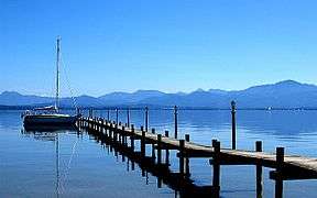
Chiemsee (German pronunciation: [ˈkiːmzeː]) is a freshwater lake in Bavaria,[2] Germany, near Rosenheim. It is often called "the Bavarian Sea". The rivers Großache and Prien flow into the lake from the south, and the river Alz flows out towards the north. The Alz flows into the Inn which then merges with the Danube. The Chiemsee is divided into the bigger, north section, in the northeast, called Weitsee, and the Inselsee, in the southwest.
The Chiemgau, the region surrounding the Chiemsee, is a famous recreation area.

Origin
The Chiemsee was formed, like many other pre-alpine lakes, at the end of the last ice age about 10,000 years ago from a hollow carved out by a glacier (a Zungenbecken). Originally the lake covered an area of almost 240 km2 (93 sq mi), which is about three times its present area. Within 10,000 years its area had shrunk to around 80 km2 (31 sq mi). Before 1904 the water level was lowered by about a metre. As a result, large areas of dry land were reclaimed.
Islands
There are three main islands on the lake: Herreninsel, the largest, with an area of 238 hectares (590 acres); Frauenchiemsee, 15.5 ha (38 acres), also called Herreninsel ("gentlemen's island") and Fraueninsel ("ladies' island"); and uninhabited Krautinsel,[2] 3.5 ha (8.6 acres). It is known as "Cabbage Island" because in the Middle Ages it was cultivated with cabbages and other vegetables.[3]
- Herreninsel has a palace built by King Ludwig II in 1878 called Herrenchiemsee, which was never completed but was meant to be a replica of the Palace of Versailles. Many of its rooms are open to tourists; tours of the palace and its extensive grounds are conducted throughout the summer.
- Frauenchiemsee, the smaller of the two main islands, houses a Benedictine nunnery, built in 782, as well as a small village. The nuns make a liquor called Klosterlikör ("cloister liquor") and marzipan (almond paste).
The smallest island in the lake is the Schalch 66 m (217 ft) west of Frauenchiemsee, which is of square outline, with a side length of only 4.7 m (15 ft) or an area of 22 m2 (240 sq ft). This tiny island had probably been created artificially to mark a shallow spot for sailboats. There is a willow on the island, originally planted in 1935, and replace by a young tree in the 2000s.
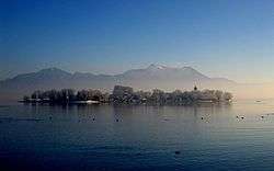 Fraueninsel in winter
 Fraueninsel with convent
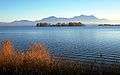 Krautinsel
 Herreninsel
 Chiemsee in winter
 Chiemsee in autumn
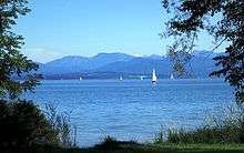 Chiemsee in summer
 View from the Alps
References
- ↑ "Chiemsee". Ramsar Sites Information Service. Retrieved 25 April 2018.
- 1 2

- ↑ "Archived copy". Archived from the original on 2015-12-17. Retrieved 2015-06-01.
External links
| Wikimedia Commons has media related to Chiemsee. |

- Nixdorf, B.; et al. (2004), "Chiemsee", Dokumentation von Zustand und Entwicklung der wichtigsten Seen Deutschlands (in German), Berlin: Umweltbundesamt, p. 17