Cheongju
| Cheongju 청주시 | |
|---|---|
| Specific city | |
| Korean transcription(s) | |
| • Hangul | 청주시 |
| • Hanja | 淸州市 |
| • Revised Romanization | Cheongju-si |
| • McCune-Reischauer | Ch'ŏngju-si |
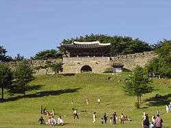 A front view of Sangdangsanseong | |
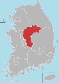
 Location in South Korea | |
| Coordinates: 36°38′N 127°29′E / 36.633°N 127.483°E | |
| Country |
|
| Region | Hoseo |
| First mention | 940 |
| Founded | 1949 |
| Administrative divisions | 4 gu 30 dong |
| Area | |
| • Total | 940.3 km2 (363.1 sq mi) |
| Elevation | 39 m (128 ft) |
| Population (2014) | |
| • Total | 838,689 |
| • Density | 890/km2 (2,300/sq mi) |
| • Dialect | Chungcheong |
| Postal code | 28200~27999 |
| Area code(s) | (+82) 43-2xx |
| Website | Official website |
Cheongju (Korean pronunciation: [tɕʰʌŋ.dʑu]) is the capital and largest city of North Chungcheong Province in South Korea.
History
Cheongju has been an important provincial town since ancient times.
During Hideyoshi's Invasions of Korea, Cheongju was the site of the Battle of Chongju, during which the Korean forces re-took the city from the Japanese forces in an important early victory.
The government of the province relocated here from Chungju in 1908.
The opening of the Chungbuk-line in 1926 sparked regional development. In 1946, Cheongju and Cheongwon-gun were separated, and in 1949, Cheongju was upgraded to Cheongju City. Afterwards, it went through the separation of administrative dong and their transfer to Cheongwon-gun, with 2 branch offices (East and West)established in July 1989 that were upgraded to Sangdang-gu and Heungdeok-gu in January.[1]
Geography
Geum River goes through right center of Cheongju city. Additionally, the tributaries of Musim and Miho flow together in northern part of city. To east and west, there are mountains of Wuam and Bumo. Musimcheon River goes through the middle of Cheongju city.
Climate
Cheongju is a temperate zone, so there are four seasons.
| Climate data for Cheongju (1981–2010, extremes 1967–present) | |||||||||||||
|---|---|---|---|---|---|---|---|---|---|---|---|---|---|
| Month | Jan | Feb | Mar | Apr | May | Jun | Jul | Aug | Sep | Oct | Nov | Dec | Year |
| Record high °C (°F) | 15.6 (60.1) |
19.7 (67.5) |
25.9 (78.6) |
31.3 (88.3) |
34.5 (94.1) |
35.1 (95.2) |
37.8 (100) |
37.8 (100) |
34.3 (93.7) |
29.1 (84.4) |
25.1 (77.2) |
18.3 (64.9) |
37.8 (100) |
| Average high °C (°F) | 2.9 (37.2) |
6.0 (42.8) |
11.9 (53.4) |
19.5 (67.1) |
24.4 (75.9) |
27.9 (82.2) |
29.8 (85.6) |
30.5 (86.9) |
26.3 (79.3) |
20.7 (69.3) |
12.7 (54.9) |
5.6 (42.1) |
18.2 (64.8) |
| Daily mean °C (°F) | −2.4 (27.7) |
0.3 (32.5) |
5.7 (42.3) |
12.6 (54.7) |
18.1 (64.6) |
22.5 (72.5) |
25.4 (77.7) |
25.8 (78.4) |
20.7 (69.3) |
14.0 (57.2) |
6.7 (44.1) |
0.3 (32.5) |
12.5 (54.5) |
| Average low °C (°F) | −6.9 (19.6) |
−4.6 (23.7) |
0.2 (32.4) |
6.1 (43) |
12.3 (54.1) |
17.6 (63.7) |
21.8 (71.2) |
22.0 (71.6) |
16.2 (61.2) |
8.5 (47.3) |
1.7 (35.1) |
−4.3 (24.3) |
7.6 (45.7) |
| Record low °C (°F) | −24.1 (−11.4) |
−26.4 (−15.5) |
−12.5 (9.5) |
−4.8 (23.4) |
2.8 (37) |
7.9 (46.2) |
12.3 (54.1) |
12.7 (54.9) |
3.7 (38.7) |
−4.3 (24.3) |
−11.0 (12.2) |
−20.6 (−5.1) |
−26.4 (−15.5) |
| Average precipitation mm (inches) | 25.5 (1.004) |
29.4 (1.157) |
48.2 (1.898) |
66.6 (2.622) |
88.3 (3.476) |
144.1 (5.673) |
282.7 (11.13) |
285.1 (11.224) |
147.1 (5.791) |
50.1 (1.972) |
46.7 (1.839) |
25.3 (0.996) |
1,239.1 (48.783) |
| Average precipitation days (≥ 0.1 mm) | 8.0 | 7.0 | 8.8 | 7.9 | 8.5 | 9.6 | 15.9 | 14.1 | 9.1 | 6.5 | 8.6 | 9.1 | 113.1 |
| Average snowy days | 9.6 | 5.6 | 3.1 | 0.1 | 0.0 | 0.0 | 0.0 | 0.0 | 0.0 | 0.1 | 2.1 | 7.7 | 28.3 |
| Average relative humidity (%) | 67.2 | 63.3 | 60.3 | 56.6 | 61.5 | 68.0 | 76.4 | 76.1 | 74.2 | 70.4 | 69.1 | 69.1 | 67.7 |
| Mean monthly sunshine hours | 164.0 | 171.1 | 200.2 | 222.7 | 234.1 | 195.5 | 153.1 | 178.3 | 177.5 | 200.0 | 158.2 | 158.0 | 2,212.6 |
| Percent possible sunshine | 53.1 | 55.9 | 54.0 | 56.6 | 53.5 | 44.6 | 34.3 | 42.5 | 47.6 | 57.3 | 51.5 | 52.4 | 49.7 |
| Source: Korea Meteorological Administration[2][3][4] (percent sunshine and snowy days)[5] | |||||||||||||
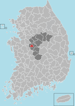
Administrative districts
From 1 July 2014, Cheongju and Cheongwon County unified, and administrative districts were changed to the following:
- Heungdeok-gu (흥덕구; 興德區) West
Osong-eup, Gangne-myeon, Oksan-myeon, Uncheon-dong, Sinbong-dong, Bokdae1-dong, Bokdae2-dong, Gakyeong-dong, Bongmyeong1-dong, Bongmyeong2-dong, Songjeong-dong, Gangseo1-dong, Gangseo2-dong, Ochang-eup
- Seowon-gu (서원구; 西原區) South
Nami-myeon, Hyeondo-myeon, Sajik1-dong, Sajik2-dong, Sachang-dong, Mochooung-dong, Sugok1-dong, Sugok2-dong, Sannam-dong, Bunpyeong-dong, Seonghwa-dong, Geasin-dong, Jookrim-dong
- Sangdang-gu (상당구; 上黨區) East
Nangseong-myeon, Miwon-myeon, Gaduk-myeon, Namil-myeon, Mooni-myeon, Joongang-dong, Seongan-dong, Top-dong, Deasung-dong, Yeongun-dong, Geumcheon-dong, Yongam-dong, Myeongam-dong, Sinsung-dong, Yongam1-dong, Yongam2-dong
- Cheongwon-gu (청원구; 淸原區) North
Nesoo-eup, Buki-myeon, Wooam-dong, Neduk1-dong, Neduk2-dong, Yoolang-dong, Sacheon-dong, Ogeunjang-dong,[6] Ochang-eup
Government and infrastructure
The headquarters of the Ministry of Food and Drug Safety are located in the Osong Health Technology Administration Complex.
Cultural properties
- Sangdangsanseong (Sangdang Mountain Fortress) lies on the slopes of Mt. Uam within the city limits. The fortress is mainly a 3-to-4-metre-tall (9.8–13.1-foot) wall that stretches over 4.2 kilometres (2.6 miles) in circumference. The present walls date to the 1716 restoration of the site. Within the walls lies a small tourist village that has several restaurants.
- Cheongju National Museum also lies near Mt. Uam, and houses several exhibits of cultural artifacts from the nearby area.
- Heungdeok Temple Site is the home to the Early Printing Museum, and is to be the site of the printing of Jikji, the oldest existent book printed using movable metal type. The museum itself contains exhibits related to the art of printing through the ages.
- Yongdusaji Cheoldanggan (The Iron Flagpole of the Yongdu Temple Site) is designated Korean National Treasure number 41, and is located near Lotte Department Store in downtown Cheongju. Made of twenty iron cylinders, the flagpole stands 13.1 metres (43.0 feet) tall, and was formerly used to hang flags to honour the Buddha
Transport
Cheongju International Airport provides scheduled flights within Korea and to China. The main train station is located at Ogeunjang approximately 8 km (5.0 mi) north of the city hall. This station is on the Chungbuk Line. Chengju Bus Terminal provides almost all of the bus lines to bus terminals located in other cities. Ticketing time is between 4:00 am and 11:40 pm. Cheongju Express Bus Terminal provides some bus lines for Seoul(Gangnam, Sangbong, South Seoul, East Seoul, Busan, East Deagu, Gwangju).
Education
Cheongju is the site of several tertiary institutions, including:
Festival
The Cheongju International Craft Biennale is usually held in September or October.[7]
There is also the Osong Cosmetic and Beauty Expo.[8]
Twin towns – sister cities
| City | Prefecture/Province/State | Country | Year | Sources |
|---|---|---|---|---|
| Tottori | 1991 | [9] | ||
| Wuhan | Hubei | 2000 | [10] | |
| Bellingham | 2008 | [11][12][13] |
References
- ↑ * Welcome to CHEONGJU-SI Homepage * Archived June 23, 2006, at the Wayback Machine.
- ↑ "평년값자료(1981-2010) 청주(131)" (in Korean). Korea Meteorological Administration. Retrieved 21 December 2016.
- ↑ "기후자료 극값(최대값) 전체년도 일최고기온 (℃) 최고순위, 청주(131)" (in Korean). Korea Meteorological Administration. Retrieved 21 December 2016.
- ↑ "기후자료 극값(최대값) 전체년도 일최저기온 (℃) 최고순위, 청주(131)" (in Korean). Korea Meteorological Administration. Retrieved 21 December 2016.
- ↑ "Climatological Normals of Korea" (PDF). Korea Meteorological Administration. 2011. p. 499 and 649. Archived from the original (PDF) on 7 December 2016. Retrieved 21 December 2016.
- ↑ 청원청주통합 홍보안내. 3 May 2014. Archived from the original on 3 May 2014.
- ↑ http://okcj.org/wp/%7CCheongju%5Bpermanent+dead+link%5D International public website
- ↑ "Archived copy". Archived from the original on 2014-03-25. Retrieved 2014-03-25.
- ↑ "Cheongju Sister Cities: Tottori city, Japan". Cheongju City. Retrieved 12 January 2017.
- ↑ "Cheongju Sister Cities: Wuhan city, China". Cheongju City. Retrieved 12 January 2017.
- ↑ "Cheongju Sister Cities: Bellingham city, U.S". Cheongju City. Retrieved 12 January 2017.
- ↑ "Our Sister Cities". Bellingham Sister Cities Association. Retrieved 20 January 2015.
- ↑ "Interactive City Directory". Sister Cities International. Archived from the original on 21 January 2015. Retrieved 20 January 2015.
External links
| Wikimedia Commons has media related to Cheongju. |

- City government home page