Mears State Park
| Charles Mears State Park | |
|---|---|
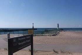 Pentwater Lake Channel at the southern edge of the park | |
 Location in Michigan | |
| Location | Lower Peninsula, Oceana County, Michigan USA |
| Nearest city | Pentwater, Michigan |
| Coordinates | 43°47′00″N 86°26′26″W / 43.78333°N 86.44056°WCoordinates: 43°47′00″N 86°26′26″W / 43.78333°N 86.44056°W [1] |
| Area | 50 acres (20 ha) |
| Elevation | 610 feet (190 m) [1] |
| Established | 1923 |
| Governing body | Michigan Department of Natural Resources |
| Website | Mears State Park |
Charles Mears State Park is a public recreation area covering 50 acres (20 ha) in the village of Pentwater, Oceana County, Michigan. The state park sits on Lake Michigan, directly north of a channel that leads into Pentwater Lake. The park land, which was once owned by lumber baron Charles Mears, was donated to the state by his daughter Carrie Mears in 1923.[2] The park offers fishing, swimming, camping, picnicking, and a one-mile (1.6 km) hiking trail that ascends the Old Baldy sand dune.[3]
References
- 1 2 "Charles Mears State Park". Geographic Names Information System. United States Geological Survey.
- ↑ "Oceana County Master Plan" (PDF). Oceana County Planning Commission. April 28, 2016. Retrieved March 8, 2018.
- ↑ "Mears State Park". Michigan Department of Natural Resources. Retrieved September 29, 2011.
External links
- Mears State Park Michigan Department of Natural Resources
- Mears State Park Map Michigan Department of Natural Resources
- Mears State Park Protected Planet
This article is issued from
Wikipedia.
The text is licensed under Creative Commons - Attribution - Sharealike.
Additional terms may apply for the media files.