Change, Nepal
| Change चाँगे गाविस | |
|---|---|
| Village development committee | |
 Change Location in Nepal | |
| Coordinates: 27°19′N 87°35′E / 27.32°N 87.58°ECoordinates: 27°19′N 87°35′E / 27.32°N 87.58°E | |
| Country |
|
| Zone | Mechi Zone |
| District | Taplejung District |
| Population (2011) | |
| • Total | 4,034 |
| Time zone | UTC+5:45 (Nepal Time) |
| Postal code | 57511 |
| Area code(s) | 024 |
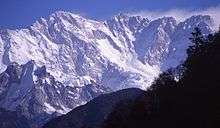
Change is a village development committee in the Himalayas of Taplejung District in the Mechi Zone of north-eastern Nepal. At the time of the 2011 Nepal census it had a population of 4,034 people living in 861 individual households.[1]There were 1,876 males and 2,158 females at the time of census.
This VDC is mainly inhaited by limbu an Mongolian descendant, including Angbuhang, an indigenous tribe. This VDC produces cash crops like orange, cardamom and tobacco. West/south to North/east orientation of the land and south facing slopes provide more sunny hours. Change has a hiking route (now being introduced as a rhododendron hiking trail) Taplejung-Gorja-Basantapur, which passes from the middle along its length. Gorja is a local camping site and picnic spot.
References
- ↑ "Nepal Census 2011". Nepal's Village Development Committees. Digital Himalaya. Archived from the original on 12 October 2008. Retrieved 19 November 2008.
External links
Headquarter: Phungling | |||
 | Rural Municipalities | 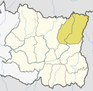 | |
| Municipalities | |||
Land orientation (West/south to North/east) and slope(south faced) has given agroclimatic advantages to Change getting more sunny days.
Taplejung-Gorja-Basantapur (now being introduced as a rhododendron hiking trail) passes by along Change length providing a good opportiunity for agrobusiness.Gorja, a popular camping site and local picnic spot brushes the natural beauty of Change VDC.