Chagrin Shale
| Chagrin Shale Stratigraphic range: Famennian | |
|---|---|
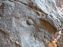 A fossil in the Chagrin Shale | |
| Type | Formation |
| Unit of | Ohio Shale |
| Underlies | Cleveland Shale, Cussewago Sandstone |
| Overlies | Huron Member |
| Location | |
| Region |
|
| Country |
|
| Type section | |
| Named for | Chagrin River |
| Named by | Charles S. Prosser |
The Chagrin Shale is a shale geologic formation in the states of Ohio and Pennsylvania in the United States that is approximately 365 million years old. Identified in 1873 and named for the Chagrin River in 1903, the greyish shale begins thin and deep underground in north-central Ohio. As it proceeds east, the formation thickens, rises to the surface, and contains greater amounts of siltstone. Marine plant and animal fossils as well as methane gas are found in the formation.
Identification and name
John Strong Newberry, director of the Ohio State Geological Survey, first identified the formation in 1873.[1] He called it the Erie Shale, but it was discovered that the name "Erie Shale" was preoccupied (already in use).[2] Ohio State University professor of geology Charles S. Prosser further described the formation in 1903, and proposed the name "Chagrin Shale" because the shale presented such excellent outcroppings near the Chagrin River.[1] Dr. Prosser's suggested nomenclature was adopted.[3]
Characteristics of the formation
The Chagrin Shale is, generally speaking, a grey[4] or greenish-gray[5] argillaceous shale[4] consisting of gray siltstone, silty gray shale, soft gray clay shale, and (uncommonly) grayish-black shale.[6] The primary minerals in the shale are chlorite, illite, kaolinite, and quartz.[5] Thin to massive beds[7] of siltstone and sandstone are common.[5] The amount of siltstone increases from west to east, at times forming beds up to 50 feet (15 m) thick.[6] Thin layers of ironstone and marcasite, as well as concentrations of marcasite, occur throughout the shale.[5]
The Chagrin Shale is classified as a weak to medium-strong rock, with a compressive strength anywhere from 5,000 pounds per square inch (34,000 kPa) to 15,000 pounds per square inch (100,000 kPa). The strength of the rock is much lower near soil/rock interface (where there is stress relief), and if there is weathering.[4]
The Chagrin Shale is found in north-central and northeastern Ohio, and in northwestern Pennsylvania.[6]
Chagrin Shale is Famennian stage rock[2] approximately 365 million years old.[8] It is a member of the Ohio Shale.[2] In most of Ohio, the Chagrin Shale underlies the Cleveland Shale.[7] Around the Ohio-Pennsylvania border and in far western Pennsylvania, it is overlaid by Cussewago Sandstone.[6]
The Chagrin Shale is thin in the west, underlying the Cleveland Shale[2] and overlying the Huron Shale.[3] It is deep underground here, and thickens as it proceeds east.[6] Studies show that the Chagrin Shale grades into and between the Cleveland and Huron shales.[2] The Cleveland Shale thins out and disappears near Andover, Ohio, and the Chagrin Shale surfaces. The Chagrin Shale reaches a maximum thickness of 1,200 feet (370 m) in eastern Ohio.[6]
Fossils and gases
The Chagrin Shale preserves fossils dating to the Devonian period.[9]
Hydrogen sulfide and (more frequently) methane gas are found in the Chagrin Shale. On some occasions, these pockets of gas have proven quite large, and when reached by drills have vented for several weeks. Water infiltration of the formation on a sustained or large scale is rarely seen.[4]
See also
Citations
- 1 2 Prosser 1913, p. 15.
- 1 2 3 4 5 Pepper, DeWitt & Demarest 1954, p. 11.
- 1 2 Wilmarth 1938, p. 393.
- 1 2 3 4 Vitale et al. 2013, p. 479.
- 1 2 3 4 Ott, Switalski & Sadowksi 1995, p. 335.
- 1 2 3 4 5 6 Pepper, DeWitt & Demarest 1954, p. 17.
- 1 2 Schafer et al. 2004, p. 449.
- ↑ Camp 2006, p. 113.
- ↑ Various Contributors to the Paleobiology Database. "Fossilworks: Gateway to the Paleobiology Database". Archived from the original on 31 July 2014. Retrieved 22 June 2014.
Bibliography
- Camp, Mark J. (2006). Roadside Geology of Ohio. Missoula, Mont.: Mountain Press Publishing. ISBN 9780878425242.
- Ott, K.R.; Switalski, D.J.; Sadowksi, D.J. (1995). "Shaft Construction Through Natural Crude Oil". In Williamson, G.E.; Gowring, I.M. Rapid Excavation and Tunneling Conference 1995 Proceedings. Englewood, Colo.: Society for Mining, Metallurgy, and Exploration. ISBN 9780873351324.
- Pepper, James F.; DeWitt, Wallace, Jr.; Demarest, David F. (1954). Geology of the Bedford Shale and Berea Sandstone in the Appalachian Basin. Geologic Survey Professional Paper 259. Washington, D.C.: U.S. Government Printing Office.
- Prosser, Charles S. (1913). "Bulletin 15, The Devonian and Mississippian of Northeast Ohio". Geological Survey of Ohio. Volume XI. Columbus, Ohio: Ohio Geological Survey.
- Schafer, M.; Lukajic, B.; Pintabona, R.; Kritzer, M.; Shively, T.; Switalski, R. (2004). "Rock Tunneling at the Mill Creek Project". In Ozdemir, Levent. North American Tunneling 2004: Proceedings of the North American Tunneling Conference 2004. New York: A.A. Balkema Publishers. ISBN 9058096696.
- Vitale, Michael G.; Jarrett, Jarrett E.; Garrod, Brian; Gabriel, Doug (2013). "Innovations in Annular Grouting at the Euclid Creek Tunnel, Cleveland, Ohio". In DiPonio, Michael A.; Dixon, Chris. Rapid Excavation and Tunneling Conference 2013 Proceedings. Englewood, Colo.: Society for Mining, Metallurgy, and Exploration. ISBN 9780873353830.
- Wilmarth, M. Grace (1938). Lexicon of Geologic Names of the United States (Including Alaska). Part 1, A-L. Geologic Survey Bulletin 896. Washington, D.C.: U.S. Government Printing Office.