Châteauneuf-les-Martigues
| Châteauneuf-les-Martigues | ||
|---|---|---|
| Commune | ||
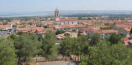 A panoramic view of Châteauneuf-les-Martigues | ||
| ||
 Châteauneuf-les-Martigues Location within Provence-A.-C.d'A. region  Châteauneuf-les-Martigues | ||
| Coordinates: 43°23′02″N 5°09′54″E / 43.3838°N 5.165°ECoordinates: 43°23′02″N 5°09′54″E / 43.3838°N 5.165°E | ||
| Country | France | |
| Region | Provence-Alpes-Côte d'Azur | |
| Department | Bouches-du-Rhône | |
| Arrondissement | Istres | |
| Canton | Marignane | |
| Intercommunality | Aix-Marseille-Provence | |
| Government | ||
| • Mayor (2014–2020) | Roland Mouren | |
| Area1 | 31.65 km2 (12.22 sq mi) | |
| Population (2008)2 | 11,564 | |
| • Density | 370/km2 (950/sq mi) | |
| Time zone | UTC+1 (CET) | |
| • Summer (DST) | UTC+2 (CEST) | |
| INSEE/Postal code | 13026 /13220 | |
| Elevation |
0–203 m (0–666 ft) (avg. 40 m or 130 ft) | |
|
1 French Land Register data, which excludes lakes, ponds, glaciers > 1 km2 (0.386 sq mi or 247 acres) and river estuaries. 2 Population without double counting: residents of multiple communes (e.g., students and military personnel) only counted once. | ||
.svg.png)
Châteauneuf-les-Martigues is a commune in the Bouches-du-Rhône department in southern France.
Population
| Historical population | ||
|---|---|---|
| Year | Pop. | ±% |
| 1793 | 571 | — |
| 1800 | 527 | −7.7% |
| 1806 | 483 | −8.3% |
| 1821 | 477 | −1.2% |
| 1831 | 714 | +49.7% |
| 1836 | 957 | +34.0% |
| 1841 | 991 | +3.6% |
| 1846 | 984 | −0.7% |
| 1851 | 1,033 | +5.0% |
| 1856 | 1,150 | +11.3% |
| 1861 | 1,220 | +6.1% |
| 1866 | 1,227 | +0.6% |
| 1872 | 1,241 | +1.1% |
| 1876 | 1,205 | −2.9% |
| 1881 | 1,013 | −15.9% |
| 1886 | 1,084 | +7.0% |
| 1891 | 1,100 | +1.5% |
| 1896 | 1,125 | +2.3% |
| 1901 | 1,073 | −4.6% |
| 1906 | 1,164 | +8.5% |
| 1911 | 1,488 | +27.8% |
| 1921 | 1,371 | −7.9% |
| 1926 | 1,523 | +11.1% |
| 1931 | 1,603 | +5.3% |
| 1936 | 2,325 | +45.0% |
| 1946 | 2,536 | +9.1% |
| 1954 | 3,611 | +42.4% |
| 1962 | 4,822 | +33.5% |
| 1968 | 6,781 | +40.6% |
| 1975 | 8,600 | +26.8% |
| 1982 | 10,173 | +18.3% |
| 1990 | 10,911 | +7.3% |
| 1999 | 11,375 | +4.3% |
| 2008 | 11,564 | +1.7% |
See also
References
| Wikimedia Commons has media related to Châteauneuf-les-Martigues. |
This article is issued from
Wikipedia.
The text is licensed under Creative Commons - Attribution - Sharealike.
Additional terms may apply for the media files.