Coudoux
| Coudoux | ||
|---|---|---|
| Commune | ||
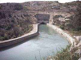 The Canal de Marseille enters a tunnel near Coudoux | ||
| ||
 Coudoux Location within Provence-A.-C.d'A. region  Coudoux | ||
| Coordinates: 43°33′31″N 5°14′57″E / 43.5586°N 5.2492°ECoordinates: 43°33′31″N 5°14′57″E / 43.5586°N 5.2492°E | ||
| Country | France | |
| Region | Provence-Alpes-Côte d'Azur | |
| Department | Bouches-du-Rhône | |
| Arrondissement | Aix-en-Provence | |
| Canton | Berre-l'Étang | |
| Intercommunality | Aix-Marseille-Provence | |
| Government | ||
| • Mayor (2008–2014) | Guy Barret | |
| Area1 | 12.65 km2 (4.88 sq mi) | |
| Population (2008)2 | 3,392 | |
| • Density | 270/km2 (690/sq mi) | |
| Time zone | UTC+1 (CET) | |
| • Summer (DST) | UTC+2 (CEST) | |
| INSEE/Postal code | 13118 /13111 | |
| Elevation |
40–277 m (131–909 ft) (avg. 103 m or 338 ft) | |
|
1 French Land Register data, which excludes lakes, ponds, glaciers > 1 km2 (0.386 sq mi or 247 acres) and river estuaries. 2 Population without double counting: residents of multiple communes (e.g., students and military personnel) only counted once. | ||
.svg.png)
Coudoux is a commune in the Bouches-du-Rhône department in southern France.
Location
It is 17 km (11 mi) away from Aix-en-Provence, 20 km (12 mi) away from Salon-de-Provence, and nearly 40 km (25 mi) away from Marseille. As for villages, it is 3 km (1.9 mi) away from Velaux, 4 km (2.5 mi) away from La Fare-les-Oliviers, 5 km (3.1 mi) away from Ventabren and about 10 km (6.2 mi) away from Éguilles.
History
As early as the 16th century, there were two hamlets, "Petit Coudoux" (Small Coudoux) and "Grand Coudoux" (Big Coudoux). However, these were affiliated to Ventabren and it was only in 1950 that Coudoux was made a village in its own right.
Population
| Historical population | ||
|---|---|---|
| Year | Pop. | ±% |
| 1954 | 457 | — |
| 1962 | 579 | +26.7% |
| 1968 | 880 | +52.0% |
| 1975 | 1,042 | +18.4% |
| 1982 | 2,228 | +113.8% |
| 1990 | 2,360 | +5.9% |
| 1999 | 2,868 | +21.5% |
| 2008 | 3,392 | +18.3% |
See also
- Communes of the Bouches-du-Rhône department
- Baone : Since 2004 Coudoux is twinned with Baone -Padua -Italy
References
External links
| Wikimedia Commons has media related to Coudoux. |