Herning Municipality
| Herning Municipality (Herning Kommune) | |
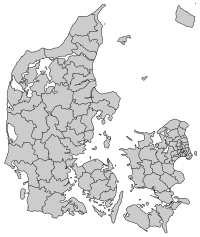
| Municipalities of Denmark | |
| Country | Denmark |
|---|---|
| Region | Region Midtjylland |
| Seat | Herning |
| - coordinates | 56°08′N 8°59′E / 56.133°N 8.983°ECoordinates: 56°08′N 8°59′E / 56.133°N 8.983°E |
| Area | 1,322.87 km2 (511 sq mi) |
| Population | 86,813 (1 April 2014) |
| Mayor | Lars Krarup (Venstre) |
| Timezone | CET (UTC1) |
| - summer (DST) | CEST (UTC2) |
 | |

Herning Municipality is a municipality (Danish, kommune) in Region Midtjylland on the Jutland peninsula in western Denmark. The municipality covers an area of 1,322.87 km2 (510.76 sq mi) and has a population of 86,813 (1 April 2014). Its mayor is Lars Krarup, a member of the Venstre (Liberal Party) political party.
The main town and the site of its municipal council is the Town of Herning.
History
On January 1, 2007, as the result of Kommunalreformen ("The Municipal Reform" of 2007), Herning municipality was merged with former Aulum-Haderup, Trehøje, and Aaskov municipalities to form the new Herning municipality.
The city of Herning
The city of Herning has a population of 44,437 (January 1, 2006). The town has grown rapidly in the 150 years: in 1840 the total population of the village of Herning was just 21.
Notable people
- Gudmund Hatt (1884 - 1960), Danish archaeologist and cultural geographer, born in Vildbjerg parish municipality, which joined with other parish municipalities in 1970 to create Trehøje Municipality.
References
- Municipal statistics: NetBorger Kommunefakta, delivered from KMD aka Kommunedata (Municipal Data)
- Municipal mergers and neighbors: Eniro new municipalities map
- Searchable/printable municipal map: Krak mapsearch (outline of municipality visible but doesn't print out)
External links

- Herning municipality's official website (in Danish)
- Destination Herning tourism information
- Sculpture Elia's website
- Opera singer Peter Lodahl
| Municipalities | 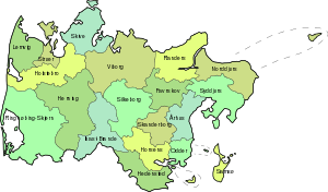 | |
|---|---|---|
| Cities and towns | ||
| Geographic features | ||
| ||