Cebolla, New Mexico
| Cebolla | |
|---|---|
| Unincorporated community | |
 Cebolla Location within the state of New Mexico  Cebolla Cebolla (the US) | |
| Coordinates: 36°32′18″N 106°29′11″W / 36.53833°N 106.48639°WCoordinates: 36°32′18″N 106°29′11″W / 36.53833°N 106.48639°W | |
| Country | United States |
| State | New Mexico |
| County | Rio Arriba |
| Elevation | 7,641 ft (2,329 m) |
| Time zone | UTC-7 (Mountain (MST)) |
| • Summer (DST) | UTC-6 (MDT) |
| Area code(s) | 575 |
| GNIS feature ID | 923578[1] |
Cebolla is an unincorporated community located in Rio Arriba County, New Mexico, United States. Cebolla is located on U.S. Route 84 44 miles (71 km) northwest of Española. Cebolla has a post office with ZIP code 87518.[2][3]
References
- ↑ "Cebolla". Geographic Names Information System. United States Geological Survey.
- ↑ "Postmaster Finder - Post Offices by ZIP Code". United States Postal Service. Retrieved November 9, 2014.
- ↑ United States Postal Service. "USPS - Look Up a ZIP Code". Retrieved November 9, 2014.
Municipalities and communities of Rio Arriba County, New Mexico, United States | ||
|---|---|---|
| City | 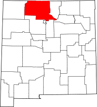 | |
| Village | ||
| CDPs |
| |
| Other unincorporated communities | ||
| Ghost towns and former settlements | ||
| Indian reservations | ||
| Footnotes | ‡This populated place also has portions in an adjacent county or counties | |
This article is issued from
Wikipedia.
The text is licensed under Creative Commons - Attribution - Sharealike.
Additional terms may apply for the media files.