506 Carlton
| 506 Carlton | |||||||||||||||||||||||||||||||||||||||||||||||||||||||||||||||||||||||||||||||||||||||||||||||||||||||||||||||||||||||||||||||||||||||||||||||||||||||||||||||||||||||||||||||||||||||||||||||||||||||||||||||||||||||||||||||||||||||||||||||||||||||||||||||||||||||||||||||||||||||||||||||||||||||||||||||||||||||||||||||||||||||||||||||||||||||||||||||||||||||||||||||||||||||||||||||||||||||||||||||
|---|---|---|---|---|---|---|---|---|---|---|---|---|---|---|---|---|---|---|---|---|---|---|---|---|---|---|---|---|---|---|---|---|---|---|---|---|---|---|---|---|---|---|---|---|---|---|---|---|---|---|---|---|---|---|---|---|---|---|---|---|---|---|---|---|---|---|---|---|---|---|---|---|---|---|---|---|---|---|---|---|---|---|---|---|---|---|---|---|---|---|---|---|---|---|---|---|---|---|---|---|---|---|---|---|---|---|---|---|---|---|---|---|---|---|---|---|---|---|---|---|---|---|---|---|---|---|---|---|---|---|---|---|---|---|---|---|---|---|---|---|---|---|---|---|---|---|---|---|---|---|---|---|---|---|---|---|---|---|---|---|---|---|---|---|---|---|---|---|---|---|---|---|---|---|---|---|---|---|---|---|---|---|---|---|---|---|---|---|---|---|---|---|---|---|---|---|---|---|---|---|---|---|---|---|---|---|---|---|---|---|---|---|---|---|---|---|---|---|---|---|---|---|---|---|---|---|---|---|---|---|---|---|---|---|---|---|---|---|---|---|---|---|---|---|---|---|---|---|---|---|---|---|---|---|---|---|---|---|---|---|---|---|---|---|---|---|---|---|---|---|---|---|---|---|---|---|---|---|---|---|---|---|---|---|---|---|---|---|---|---|---|---|---|---|---|---|---|---|---|---|---|---|---|---|---|---|---|---|---|---|---|---|---|---|---|---|---|---|---|---|---|---|---|---|---|---|---|---|---|---|---|---|---|---|---|---|---|---|---|---|---|---|---|---|---|---|---|---|---|---|---|---|---|---|---|---|---|---|---|---|---|---|---|---|---|---|---|---|---|---|---|---|---|---|---|---|---|---|---|---|---|---|---|---|---|---|---|---|---|---|---|---|---|---|---|---|---|---|---|
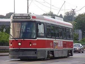 CLRV #4059 heads north on Main Street towards the eastern terminus | |||||||||||||||||||||||||||||||||||||||||||||||||||||||||||||||||||||||||||||||||||||||||||||||||||||||||||||||||||||||||||||||||||||||||||||||||||||||||||||||||||||||||||||||||||||||||||||||||||||||||||||||||||||||||||||||||||||||||||||||||||||||||||||||||||||||||||||||||||||||||||||||||||||||||||||||||||||||||||||||||||||||||||||||||||||||||||||||||||||||||||||||||||||||||||||||||||||||||||||||
| Overview | |||||||||||||||||||||||||||||||||||||||||||||||||||||||||||||||||||||||||||||||||||||||||||||||||||||||||||||||||||||||||||||||||||||||||||||||||||||||||||||||||||||||||||||||||||||||||||||||||||||||||||||||||||||||||||||||||||||||||||||||||||||||||||||||||||||||||||||||||||||||||||||||||||||||||||||||||||||||||||||||||||||||||||||||||||||||||||||||||||||||||||||||||||||||||||||||||||||||||||||||
| Type | Streetcar Route | ||||||||||||||||||||||||||||||||||||||||||||||||||||||||||||||||||||||||||||||||||||||||||||||||||||||||||||||||||||||||||||||||||||||||||||||||||||||||||||||||||||||||||||||||||||||||||||||||||||||||||||||||||||||||||||||||||||||||||||||||||||||||||||||||||||||||||||||||||||||||||||||||||||||||||||||||||||||||||||||||||||||||||||||||||||||||||||||||||||||||||||||||||||||||||||||||||||||||||||||
| Locale | Toronto, Ontario, Canada | ||||||||||||||||||||||||||||||||||||||||||||||||||||||||||||||||||||||||||||||||||||||||||||||||||||||||||||||||||||||||||||||||||||||||||||||||||||||||||||||||||||||||||||||||||||||||||||||||||||||||||||||||||||||||||||||||||||||||||||||||||||||||||||||||||||||||||||||||||||||||||||||||||||||||||||||||||||||||||||||||||||||||||||||||||||||||||||||||||||||||||||||||||||||||||||||||||||||||||||||
| Termini |
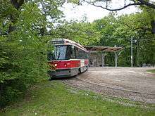
Main Street station (East) High Park Loop (West) | ||||||||||||||||||||||||||||||||||||||||||||||||||||||||||||||||||||||||||||||||||||||||||||||||||||||||||||||||||||||||||||||||||||||||||||||||||||||||||||||||||||||||||||||||||||||||||||||||||||||||||||||||||||||||||||||||||||||||||||||||||||||||||||||||||||||||||||||||||||||||||||||||||||||||||||||||||||||||||||||||||||||||||||||||||||||||||||||||||||||||||||||||||||||||||||||||||||||||||||||
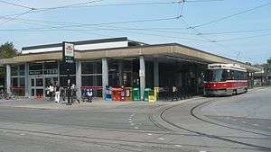
| Stations |
| ||||||||||||||||||||||||||||||||||||||||||||||||||||||||||||||||||||||||||||||||||||||||||||||||||||||||||||||||||||||||||||||||||||||||||||||||||||||||||||||||||||||||||||||||||||||||||||||||||||||||||||||||||||||||||||||||||||||||||||||||||||||||||||||||||||||||||||||||||||||||||||||||||||||||||||||||||||||||||||||||||||||||||||||||||||||||||||||||||||||||||||||||||||||||||||||||||||||||||||||
| Daily ridership | 39,601 (2014)[1] | ||||||||||||||||||||||||||||||||||||||||||||||||||||||||||||||||||||||||||||||||||||||||||||||||||||||||||||||||||||||||||||||||||||||||||||||||||||||||||||||||||||||||||||||||||||||||||||||||||||||||||||||||||||||||||||||||||||||||||||||||||||||||||||||||||||||||||||||||||||||||||||||||||||||||||||||||||||||||||||||||||||||||||||||||||||||||||||||||||||||||||||||||||||||||||||||||||||||||||||||
| Operation | |||||||||||||||||||||||||||||||||||||||||||||||||||||||||||||||||||||||||||||||||||||||||||||||||||||||||||||||||||||||||||||||||||||||||||||||||||||||||||||||||||||||||||||||||||||||||||||||||||||||||||||||||||||||||||||||||||||||||||||||||||||||||||||||||||||||||||||||||||||||||||||||||||||||||||||||||||||||||||||||||||||||||||||||||||||||||||||||||||||||||||||||||||||||||||||||||||||||||||||||
| Operator(s) | Toronto Transit Commission | ||||||||||||||||||||||||||||||||||||||||||||||||||||||||||||||||||||||||||||||||||||||||||||||||||||||||||||||||||||||||||||||||||||||||||||||||||||||||||||||||||||||||||||||||||||||||||||||||||||||||||||||||||||||||||||||||||||||||||||||||||||||||||||||||||||||||||||||||||||||||||||||||||||||||||||||||||||||||||||||||||||||||||||||||||||||||||||||||||||||||||||||||||||||||||||||||||||||||||||||
| Rolling stock | CLRV | ||||||||||||||||||||||||||||||||||||||||||||||||||||||||||||||||||||||||||||||||||||||||||||||||||||||||||||||||||||||||||||||||||||||||||||||||||||||||||||||||||||||||||||||||||||||||||||||||||||||||||||||||||||||||||||||||||||||||||||||||||||||||||||||||||||||||||||||||||||||||||||||||||||||||||||||||||||||||||||||||||||||||||||||||||||||||||||||||||||||||||||||||||||||||||||||||||||||||||||||
| Technical | |||||||||||||||||||||||||||||||||||||||||||||||||||||||||||||||||||||||||||||||||||||||||||||||||||||||||||||||||||||||||||||||||||||||||||||||||||||||||||||||||||||||||||||||||||||||||||||||||||||||||||||||||||||||||||||||||||||||||||||||||||||||||||||||||||||||||||||||||||||||||||||||||||||||||||||||||||||||||||||||||||||||||||||||||||||||||||||||||||||||||||||||||||||||||||||||||||||||||||||||
| Line length | 14.815 km (9.21 mi) [2] | ||||||||||||||||||||||||||||||||||||||||||||||||||||||||||||||||||||||||||||||||||||||||||||||||||||||||||||||||||||||||||||||||||||||||||||||||||||||||||||||||||||||||||||||||||||||||||||||||||||||||||||||||||||||||||||||||||||||||||||||||||||||||||||||||||||||||||||||||||||||||||||||||||||||||||||||||||||||||||||||||||||||||||||||||||||||||||||||||||||||||||||||||||||||||||||||||||||||||||||||
| Track gauge | 4 ft 10 7⁄8 in (1,495 mm) - TTC gauge | ||||||||||||||||||||||||||||||||||||||||||||||||||||||||||||||||||||||||||||||||||||||||||||||||||||||||||||||||||||||||||||||||||||||||||||||||||||||||||||||||||||||||||||||||||||||||||||||||||||||||||||||||||||||||||||||||||||||||||||||||||||||||||||||||||||||||||||||||||||||||||||||||||||||||||||||||||||||||||||||||||||||||||||||||||||||||||||||||||||||||||||||||||||||||||||||||||||||||||||||
| Electrification | 600 VDC Overhead | ||||||||||||||||||||||||||||||||||||||||||||||||||||||||||||||||||||||||||||||||||||||||||||||||||||||||||||||||||||||||||||||||||||||||||||||||||||||||||||||||||||||||||||||||||||||||||||||||||||||||||||||||||||||||||||||||||||||||||||||||||||||||||||||||||||||||||||||||||||||||||||||||||||||||||||||||||||||||||||||||||||||||||||||||||||||||||||||||||||||||||||||||||||||||||||||||||||||||||||||
| |||||||||||||||||||||||||||||||||||||||||||||||||||||||||||||||||||||||||||||||||||||||||||||||||||||||||||||||||||||||||||||||||||||||||||||||||||||||||||||||||||||||||||||||||||||||||||||||||||||||||||||||||||||||||||||||||||||||||||||||||||||||||||||||||||||||||||||||||||||||||||||||||||||||||||||||||||||||||||||||||||||||||||||||||||||||||||||||||||||||||||||||||||||||||||||||||||||||||||||||
The 506 Carlton is a streetcar route run by the Toronto Transit Commission in Toronto, Ontario, Canada. A part of the Toronto streetcar system, it runs from Main Street station on subway Line 2 Bloor–Danforth to High Park. Despite the route's name, less than 10% of its length actually uses Carlton Street.
Route
The Carlton line runs from the eastern terminus of Main Street Station (on Line 2 Bloor–Danforth), initially heading south on Main Street to Gerrard Street East. It then turns west onto Gerrard Street East and runs to Parliament Street where it turns north to Carlton Street. The streetcar goes west on Carlton Street, which at Yonge Street continues onto College Street. There, it passes College station on subway Line 1 Yonge–University. Continuing west, it passes Queen's Park station again on Line 1 Yonge–University. The route makes its way to the end of College Street at Dundas Street West. It then runs west on Dundas Street West to Howard Park Avenue, which it follows into its western terminus in High Park.
Some eastbound Carlton streetcars may short turn at Coxwell Avenue, and head southbound to loop at Queen Street East and Coxwell Avenue.
Streetcar service is provided 24 hours per day on most portions of the route. The late night trips operate as the 306 Carlton, which runs along the same route from the eastern terminus of Main Street Station to Dundas Street West. From there, it continues west along Dundas Street West to Dundas West Station, skipping Howard Park Avenue.
History
There were several versions of the Carlton route starting from August 1886 when the Toronto Street Railway created a horsecar line of that name. All versions traveled along Carlton Street but had a variety of terminals, and none of the earlier versions of the route had the east-west breadth of today's route.[3]
By July 1, 1923, the Carlton route had evolved to resemble today's 506 Carlton route. There were three differences between the 1923 route and today's route. In 1923, College Street terminated at Lansdowne Avenue; thus, the tracks for the Carlton route needed to turn south for one short block on Lansdowne Avenue to join the tracks on Dundas Street West. At Yonge Street, Carlton and College streets were not continuous as they are today; thus, Carlton streetcars had to do a right/left jog for one block using Yonge Street. At the east end of the line, there was no loop at Main Street north of Danforth Avenue in 1923; thus, Carlton streetcars had to turn east on Danforth Avenue to terminate at the Luttrell Loop at the corner of Luttrell Avenue and Danforth Avenue.[3][4]
On June 3, 1931, the jog at Yonge Street was eliminated by realigning Carlton Street to flow into College Street. On May 9, 1940, the jog at Lansdowne Avenue was eliminated by extending College Street to directly join Dundas Street West. On May 15, 1955, a loop was constructed at the site of today's Main station, thus providing relief from streetcar congestion at the Luttrell Loop, also used by the now-defunct Bloor streetcar line. Thus, by the third change, the Carlton route matched today's 506 Carlton route.[3]
Between April 25 and June 13, 1966, the loop at Main Station was constructed on the site of the 1955 loop. Carlton streetcars started using the new loop before the subway platforms were open to the public on May 10, 1968. During construction, Carlton streetcars had to be diverted to the Luttrell Loop.[3][5]
From February 18 to September 2, 2018, 506 Carlton operated with buses instead of streetcars due to a streetcar shortage[6] and to address crowding on other streetcar routes.[7] When streetcars returned to 506 Carlton, routes 502 Downtowner and 511 Bathurst reverted to replacement buses as the streetcar shortage was still ongoing.[8]
Sites along the line (from east to west)
- Main Square (Toronto) (at intersection of Main and Danforth)
- Ted Reeve Arena (at intersection of Main and Gerrard streets)
- Little India (between Greenwood and Coxwell avenues)
- East Chinatown (between Carlaw and Broadview avenues)
- Cabbagetown (between Don River and Parliament Street)
- Regent Park (between River and Shuter streets)
- Allan Gardens (between Sherbourne and Jarvis streets)
- Maple Leaf Gardens (at Church Street)
- College Park (at Yonge Street)
- Toronto Police headquarters (at Bay Streer)
- Queen's Park (at University Avenue)
- Toronto General Hospital (at University Avenue)
- University of Toronto (between University and Spadina avenues)
- Kensington Market (at Spadina Avenue)
- Little Italy (between Bathurst Street and Ossington Avenue)
- Roncesvalles (at Roncesvalles Avenue)
- High Park (western terminus)
References
- ↑ TTC Open Data (September 2014). "TTC Ridership - All Day Weekday for Surface Routes". Toronto Transit Commission. Retrieved January 1, 2017.
- ↑ Toronto Transit Commission (September 18, 2009). "TTC Service Summary" (PDF).
- 1 2 3 4 Bow, James (September 6, 2017). "Route 506 - The Carlton Streetcar". Transit Toronto. Retrieved January 25, 2018.
- ↑ Bow, James. "System Map – 1930". Toronto Transportation Commission. Retrieved January 25, 2018.
- ↑ "2013 TTC Operating Statistics". Toronto Transit Commission. Retrieved January 27, 2017.
- ↑ "506 Carlton - Temporary bus replacement - Streetcar shortage". Toronto Transit Commission. February 18, 2018. Retrieved February 5, 2018.
- ↑ Moore, Oliver (January 11, 2018). "Toronto's King streetcar sees 'spectacular' rise in ridership". The Globe and Mail. Retrieved January 12, 2018.
- ↑ "TTC service improvements and changes". Toronto Transit Commission. September 2, 2018. Archived from the original on August 29, 2018. Retrieved September 2, 2018.
External links
| Wikimedia Commons has media related to 506 Carlton. |
Route map:
- TTC map for 506 Carlton
- Bow, James. "Route 506 - The Carlton Streetcar". Transit Toronto.
| Bus |  _(14918534190).jpg) | |
|---|---|---|
| Subway | ||
| Streetcars | ||
| History | ||
| Predecessors |
| |
| Facilities | ||
| Proposed | ||
| Miscellaneous | ||
Italics indicate a project under construction | ||