Macugnaga
| Macugnaga | |
|---|---|
| Comune | |
| Comune di Macugnaga | |
 | |
 Macugnaga Location of Macugnaga in Italy | |
| Coordinates: 45°58′N 7°58′E / 45.967°N 7.967°ECoordinates: 45°58′N 7°58′E / 45.967°N 7.967°E | |
| Country | Italy |
| Region | Piedmont |
| Province | Verbano-Cusio-Ossola (VB) |
| Frazioni | Borca, Motta, Pecetto, Pestarena, Quarazza, Stabioli, Staffa (municipal seat) |
| Government | |
| • Mayor | Stefano Corsi |
| Area | |
| • Total | 99.57 km2 (38.44 sq mi) |
| Elevation | 1,327 m (4,354 ft) |
| Population (30 September 2017)[1] | |
| • Total | 554 |
| • Density | 5.6/km2 (14/sq mi) |
| Demonym(s) | Macugnaghesi |
| Time zone | UTC+1 (CET) |
| • Summer (DST) | UTC+2 (CEST) |
| Postal code | 28876 |
| Dialing code | 0324 |
| Patron saint | Assummption of Mary |
| Saint day | 15 August |
| Website | Official website |
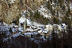
Macugnaga (Walser German: Z'Makana) is a mountain village at 1,327 metres (4,354 ft) elevation, in the province of Verbano-Cusio-Ossola, in the north of the Piedmont region of Italy.
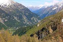
It is located at the base of Monte Rosa (4,638 metres (15,217 ft), the second-tallest mountain in Europe, along Valle Anzasca, one of the seven valleys around the mount.
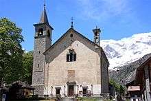
Sights in the town include the Chiesa Vecchia and its linden also of the 13th century, the Chiesa Nuova built in 1707, the 17th century Casa Pala. The town also houses a museum of mountaineering, while in the hamlet of Borca is the Walser Museum, devoted to the local German population who colonised the valley during the Middle Ages coming from the Swiss canton Wallis.
The area gives many opportunities for skiing in winter (a cableway brings from the central square of the town to the 3000 m (9800 ft) of the Passo del Monte Moro on the border with Switzerland, and hiking and mountaineering in summer. There are a swimming pool, a tennis centre, and a football field for sport activities.
The village is also known for its mine (Miniera della Guia).
Twin cities
References
External links
