Capel River
| Capel River | |
|---|---|
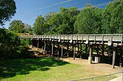 Bridge over the Capel River at Capel | |
| Country | Australia |
| Physical characteristics | |
| Main source |
Junction of Capel River North and Capel River South 76 metres (249 ft)[1] |
| River mouth |
Geographe Bay sea level |
| Length | 32 kilometres (20 mi)[2] |
| Basin features | |
| Basin size | 653 square kilometres (252 sq mi)[3] |
The Capel River is a river in the South West of Western Australia that rises in the Darling Range east of Mullalyup, and flows into the Indian Ocean at Peppermint Grove Beach.
The river was named after Capel Carter Brockman (1839–1924),[4] daughter of John Bussell (1803–1875),[5] who was named after a Miss Capel Carter, a cousin of the Bussells in England with whom the Bussell family members corresponded.
The Capel River is the largest in the Geographe catchment. It rises at the edge of the Darling Scarp and flows in a north-westerly direction across the northern part of the Blackwood plateau to the confluence of the Capel River North and Capel River South, near Goodwood.
The river crosses the Bussell Highway near Capel.
An artificial river mouth was cut through the sand dunes adjacent to the Stirling Wetlands in 1880 to allow it to flow directly into Geographe Bay.[6]
The Capel river has 6 tributaries; Capel River North, Capel River South, Gynudup Brook, Camp Gully, Layman Gully and Maidenhair Gully.
The inaugural 2009 Ranger Outdoors Capel Descent[7] was held in June 2009 which consisted of a 15 kilometres (9 mi) part down river, part open ocean paddle along the Capel River and Geographe Bay.
References
- ↑ "Bonzle Digital Atlas - Map of Capel River, WA". 2008. Retrieved 23 November 2008.
- ↑ Western Australian Land Information Authority. "History of river names". Archived from the original on 16 February 2015. Retrieved 3 September 2011.
- ↑ "Capel River Action Plan". 2007. Archived from the original on 31 August 2007. Retrieved 26 September 2007.
- ↑ 'Brockman, Capel Carter (1839–1924)', Obituaries Australia, National Centre of Biography, Australian National University, accessed 7 April 2013.
- ↑ Freda Vines Carmody (1966) 'Bussell, John Garrett (1803–1875)', Australian Dictionary of Biography, Volume 1, (MUP)
- ↑ "Regional Saltwatch Snapshot pages". 2007. Archived from the original on 29 August 2007. Retrieved 26 September 2007.
- ↑ "Capel Descent". 2009. Retrieved 23 June 2009.
Coordinates: 33°34′37″S 115°35′31″E / 33.57694°S 115.59194°E
Rivers of Western Australia | |
|---|---|
| Rivers of the Gascoyne region | |
| Rivers of the Goldfields-Esperance region | |
| Rivers of the Great Southern region | |
| Rivers of the Kimberley region |
|
| Rivers of the Mid West region | |
| Rivers of the Peel and Perth regions | |
| Rivers of the Pilbara region | |
| Rivers of the South West region | |
| Rivers of the Wheatbelt region | |
| |