Sutherland, Northern Cape
| Sutherland | |
|---|---|
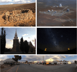 Top left: Fort Steenbok, a fortification from the Second Boer War. Top right: an aerial view of the South African Astronomical Observatory. Middle left: the main church in the town centre. Middle right: a view of the stars in the nights sky in Sutherland. Bottom: a panoramic view of the town centre facing away from the main church. | |
 Sutherland  Sutherland Sutherland (South Africa)  Sutherland Sutherland (Africa) | |
| Coordinates: 32°23′37″S 20°39′41″E / 32.39361°S 20.66139°ECoordinates: 32°23′37″S 20°39′41″E / 32.39361°S 20.66139°E | |
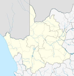
| Country | South Africa |
| Province | Northern Cape |
| District | Namakwa |
| Municipality | Karoo Hoogland |
| Established | 1858 |
| Area[1] | |
| • Total | 35.98 km2 (13.89 sq mi) |
| Elevation | 1,460 m (4,790 ft) |
| Population (2011)[1] | |
| • Total | 2,836 |
| • Density | 79/km2 (200/sq mi) |
| Racial makeup (2011)[1] | |
| • Black African | 8.0% |
| • Coloured | 78.2% |
| • Indian/Asian | 0.8% |
| • White | 12.7% |
| • Other | 0.3% |
| First languages (2011)[1] | |
| • Afrikaans | 96.0% |
| • English | 1.9% |
| • Other | 2.1% |
| Time zone | UTC+2 (SAST) |
| Postal code (street) | 6920 |
| PO box | 6920 |
| Area code | 023 |
Sutherland is a town with about 2,841 inhabitants in the Northern Cape province of South Africa.[2] It lies in the western Roggeveld Mountains in the Karoo.
History
Sutherland was founded in 1857 as a church and market town to serve the area's sheep farmers. By 1872 the town had a population of 138 registered citizens living in 19 houses.[3] The large Dutch Reformed church in the centre of Sutherland was built in 1899.[4]
During the Anglo Boer War the church was used as a fort by garrisoned British soldiers. During the war a number of engagements between British and Boer forces occurred in the town. In one such engagement a force of 250 Boer commandos attacked the local British garrison for 10 hours. The ruins of a fort can be found on the outskirts of town on the hill called Rebelskop. This was named after this engagement.[5]
Economy
Major economic activities include tourism and sheep farming.[6] The area includes at least twelve registered B&B's, guest houses and guest farms.[7] The nearby South African Astronomical Observatory also plays a significant role in the town's economy and is a major driver of tourism to the area.[5] The town also has a number of bars, restaurants and an amateur astronomy observatory that service the tourism sector.[5]
Sutherland has recently gained in popularity, with many Capetonians buying property in the town and many more visiting on weekends and vacations.
Geography
Sutherland's arid climate and remote location 1,450 metres (4,760 ft) above sea level make its night skies among the world's clearest and darkest. The telescopes of the South African Astronomical Observatory are nearby at 32°22′46″S 20°48′38.5″E / 32.37944°S 20.810694°E. These include the Southern African Large Telescope (SALT), the largest single optical telescope in the southern hemisphere.[8]
Climate
Sutherland is the coldest town in South Africa, with an average yearly temperature of 11.3 °C and an average annual minimum temperature of 2.8 °C;[9] although the farm Buffelsfontein holds the official lowest temperature record in the country, of −20.1 °C (−4 °F).[10] Snowfall is common in winter. The coldest temperature recorded in Sutherland was −16.4 °C on 12 July 2003.[9] Sutherland has a semi-arid climate (Köppen climate classification BSk).
| Climate data for Sutherland | |||||||||||||
|---|---|---|---|---|---|---|---|---|---|---|---|---|---|
| Month | Jan | Feb | Mar | Apr | May | Jun | Jul | Aug | Sep | Oct | Nov | Dec | Year |
| Average high °C (°F) | 27 (81) |
27 (81) |
24 (75) |
20 (68) |
16 (61) |
12 (54) |
12 (54) |
14 (57) |
16 (61) |
20 (68) |
23 (73) |
25 (77) |
19 (66) |
| Daily mean °C (°F) | 17 (63) |
18 (64) |
15 (59) |
11 (52) |
8 (46) |
5 (41) |
5 (41) |
6 (43) |
8 (46) |
11 (52) |
14 (57) |
16 (61) |
11 (52) |
| Average low °C (°F) | 8 (46) |
8 (46) |
6 (43) |
3 (37) |
0 (32) |
−1 (30) |
−2 (28) |
−1 (30) |
0 (32) |
2 (36) |
5 (41) |
7 (45) |
2 (36) |
| Record low °C (°F) | — | — | — | — | — | −15 (5) |
−16.4 (2.5) |
— | — | — | — | — | −16.4 (2.5) |
| Average precipitation mm (inches) | 12 (0.47) |
17 (0.67) |
27 (1.06) |
25 (0.98) |
24 (0.94) |
34 (1.34) |
25 (0.98) |
24 (0.94) |
15 (0.59) |
15 (0.59) |
15 (0.59) |
12 (0.47) |
244 (9.61) |
| Average snowy days | 0 | 0 | 0 | 0 | 0.4 | 1.4 | 2.3 | 1.1 | 0.3 | 0 | 0 | 0 | 5.5 |
| Source: [11] | |||||||||||||
Notable residents
Notable residents of Sutherland include:
- NP van Wyk Louw, famous Afrikaner poet and elder brother of WEG Louw was born in Sutherland.
- WEG Louw, famous Afrikaner poet and younger brother of NP van Wyk Louw was born in Sutherland.
- Dr Henry Olivier, chief engineer of the Kariba Dam project and contributing inventor of the Mulberry Harbours was born in Sutherland.
- Adriaan Vlok, national government minister of Law and Order from 1986-1991 was born in Sutherland.
- André van der Merwe, a famous South African urologist born in Sutherland.
See also
References
- 1 2 3 4 "Main Place Sutherland". Census 2011.
- ↑ "World Gazetteer". Archived from the original on 5 January 2013.
- ↑ "About Sutherland". Kambrokind. Kambrokind. Retrieved 5 April 2015.
- ↑ Roberts, Trygve (17 August 2014). "Sutherland, Northern Cape, South Africa - A real-time tour". Youtube. Retrieved 5 April 2015.
- 1 2 3 Du Plessis, Jolene (April 2012). "Sutherland's environment and history make it one of SA's more interesting dorps. And then, of course, it's the home of SALT …". Show Me. Country Life. Retrieved 5 April 2015.
- ↑ Sutherland Information Archived 24 September 2010 at the Wayback Machine.
- ↑
- ↑ SALT home page
- 1 2 South African Weather Service Archived 7 August 2011 at the Wayback Machine.
- ↑ "New minimum temperature record for South Africa". Retrieved 12 June 2014.
- ↑ Weatherbase.com Retrieved 1 August 2010.
External links
- South African Astronomical Observatory website
- Discover Sutherland
- Sutherland Tourism - official website
- Sutherland on www.karoo-southafrica.co.za
Municipalities and communities of Namakwa District Municipality, Northern Cape | ||
|---|---|---|
District seat: Springbok | ||
| Hantam | .svg.png) | |
| Kamiesberg | ||
| Karoo Hoogland | ||
| Khâi-Ma | ||
| Nama Khoi | ||
| Richtersveld | ||