Cannelton, Indiana
| Cannelton, Indiana | |
|---|---|
| City | |
| City of Cannelton | |
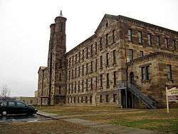 Cannelton's landmark cotton mill | |
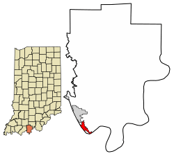 Location of Cannelton in Perry County, Indiana. | |
| Coordinates: 37°54′36″N 86°44′24″W / 37.91000°N 86.74000°WCoordinates: 37°54′36″N 86°44′24″W / 37.91000°N 86.74000°W | |
| Country | United States |
| State | Indiana |
| County | Perry |
| Township | Troy |
| Government | |
| • Mayor | Mary Snyder (R) |
| Area[1] | |
| • Total | 1.58 sq mi (4.10 km2) |
| • Land | 1.48 sq mi (3.84 km2) |
| • Water | 0.10 sq mi (0.26 km2) |
| Elevation[2] | 410 ft (125 m) |
| Population (2010)[3] | |
| • Total | 1,563 |
| • Estimate (2016)[4] | 1,494 |
| • Density | 1,008.10/sq mi (389.29/km2) |
| Time zone | UTC-6 (CST) |
| • Summer (DST) | UTC-5 (CDT) |
| ZIP code | 47520 |
| Area code(s) | 812 |
| FIPS code | 18-10108[5] |
| GNIS feature ID | 450757 |
Cannelton is a city in Troy Township, Perry County, in the U.S. state of Indiana, along the Ohio River.[6] The population was 1,563 at the 2010 census. Cannelton, which was the smallest incorporated city in the state until 2010, was formerly the county seat of Perry County until the seat was relocated to Tell City.
History
The name Cannelton was adopted in 1844, and is derived from the cannel coal that was once mined in the area.[7] A post office has been in operation at Cannelton since 1844.[8]
The Cannelton Cotton Mill, Cannelton Historic District, and St. Luke's Episcopal Church are listed on the National Register of Historic Places.[9]
Geography
Cannelton is located at 37°54′36″N 86°44′24″W / 37.91000°N 86.74000°W (37.910134, -86.739931).[10]
According to the 2010 census, Cannelton has a total area of 1.582 square miles (4.10 km2), of which 1.48 square miles (3.83 km2) (or 93.55%) is land and 0.102 square miles (0.26 km2) (or 6.45%) is water.[11]
Climate
The climate in this area is characterized by hot, humid summers and generally mild to cool winters. According to the Köppen Climate Classification system, Cannelton has a humid subtropical climate, abbreviated "Cfa" on climate maps.[12]
Demographics
| Historical population | |||
|---|---|---|---|
| Census | Pop. | %± | |
| 1860 | 2,155 | — | |
| 1870 | 2,481 | 15.1% | |
| 1880 | 1,834 | −26.1% | |
| 1890 | 1,991 | 8.6% | |
| 1900 | 2,188 | 9.9% | |
| 1910 | 2,130 | −2.7% | |
| 1920 | 2,008 | −5.7% | |
| 1930 | 2,265 | 12.8% | |
| 1940 | 2,240 | −1.1% | |
| 1950 | 2,027 | −9.5% | |
| 1960 | 1,829 | −9.8% | |
| 1970 | 2,280 | 24.7% | |
| 1980 | 2,373 | 4.1% | |
| 1990 | 1,786 | −24.7% | |
| 2000 | 1,209 | −32.3% | |
| 2010 | 1,563 | 29.3% | |
| Est. 2016 | 1,494 | [4] | −4.4% |
| U.S. Decennial Census[13] | |||
2010 census
As of the census[3] of 2010, there were 1,563 people, 687 households, and 385 families residing in the city. The population density was 1,056.1 inhabitants per square mile (407.8/km2). There were 809 housing units at an average density of 546.6 per square mile (211.0/km2). The racial makeup of the city was 97.4% White, 0.1% African American, 0.6% Native American, 0.1% Asian, 0.4% from other races, and 1.3% from two or more races. Hispanic or Latino of any race were 0.8% of the population.
There were 687 households of which 29.5% had children under the age of 18 living with them, 35.4% were married couples living together, 15.7% had a female householder with no husband present, 4.9% had a male householder with no wife present, and 44.0% were non-families. 39.4% of all households were made up of individuals and 12.4% had someone living alone who was 65 years of age or older. The average household size was 2.23 and the average family size was 2.99.
The median age in the city was 38.5 years. 25.3% of residents were under the age of 18; 8.3% were between the ages of 18 and 24; 23.7% were from 25 to 44; 27.7% were from 45 to 64; and 14.8% were 65 years of age or older. The gender makeup of the city was 48.8% male and 51.2% female.
2000 census
As of the census[5] of 2000, there were 1,209 people, 509 households, and 297 families residing in the city. The population density was 816.0 people per square mile (315.4/km²). There were 577 housing units at an average density of 389.4 per square mile (150.5/km²). The racial makeup of the city was 98.01% White, 0.08% African American, 0.33% Native American, 0.08% Asian, 0.50% from other races, and 0.99% from two or more races. Hispanic or Latino of any race were 0.58% of the population.
There were 509 households out of which 26.9% had children under the age of 18 living with them, 44.4% were married couples living together, 9.4% had a female householder with no husband present, and 41.5% were non-families. 38.1% of all households were made up of individuals and 19.3% had someone living alone who was 65 years of age or older. The average household size was 2.30 and the average family size was 3.08.
In the city, the population was spread out with 23.7% under the age of 18, 11.2% from 18 to 24, 27.3% from 25 to 44, 21.8% from 45 to 64, and 16.0% who were 65 years of age or older. The median age was 37 years. For every 100 females, there were 95.3 males. For every 100 females age 18 and over, there were 96.6 males.
The median income for a household in the city was $27,361, and the median income for a family was $37,188. Males had a median income of $26,940 versus $20,174 for females. The per capita income for the city was $13,578. About 14.9% of families and 16.0% of the population were below the poverty line, including 21.1% of those under age 18 and 5.9% of those age 65 or over.
Education
Cannelton has a public library, a branch of the Perry County Public Library.[14]
Notable people
- William P. Birchler, state representative
- Tim Whelan, film director, writer, producer and actor
Sites of interest
- Cannelton Cotton Mill, built in 1849, was once the largest industrial building in the United States west of the Allegheny Mountains. It is now a National Historic Landmark.
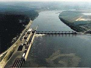
- Cannelton Locks and Dam provides a 114-mile stretch of calm recreational water on the Ohio River between Cannelton and Louisville, Kentucky.
- Northwest Orient Airlines Flight 710 Memorial. 8 miles east of town off State Road 166.
See also
References
- ↑ "2016 U.S. Gazetteer Files". United States Census Bureau. Retrieved Jul 28, 2017.
- ↑ "US Board on Geographic Names". United States Geological Survey. 2007-10-25. Retrieved 2008-01-31.
- 1 2 "American FactFinder". United States Census Bureau. Retrieved 2012-12-11.
- 1 2 "Population and Housing Unit Estimates". Retrieved June 9, 2017.
- 1 2 "American FactFinder". United States Census Bureau. Archived from the original on 2013-09-11. Retrieved 2008-01-31.
- ↑ "Cannelton, Indiana". Geographic Names Information System. United States Geological Survey. Retrieved 2017-04-14.
- ↑ History of Warrick, Spencer, and Perry Counties, Indiana : from the earliest time to the present. Goodspeeds. 1885. p. 647.
- ↑ "Perry County". Jim Forte Postal History. Retrieved 2 October 2015.
- ↑ National Park Service (2010-07-09). "National Register Information System". National Register of Historic Places. National Park Service.
- ↑ "US Gazetteer files: 2010, 2000, and 1990". United States Census Bureau. 2011-02-12. Retrieved 2011-04-23.
- ↑ "G001 - Geographic Identifiers - 2010 Census Summary File 1". United States Census Bureau. Retrieved 2015-07-28.
- ↑ Climate Summary for Cannelton, Indiana
- ↑ "Census of Population and Housing". Census.gov. Archived from the original on May 12, 2015. Retrieved June 4, 2015.
- ↑ "Cannelton Public Library". Perry County Public Library. Retrieved 14 March 2018.
Municipalities and communities of Perry County, Indiana, United States | ||
|---|---|---|
| Cities | ||
| Town | ||
| Townships | ||
| Unincorporated communities | ||