Tobin Township, Perry County, Indiana
| Tobin Township | |
|---|---|
| Township | |
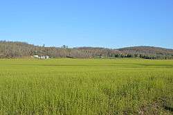 Along State Road 66 north of Rome | |
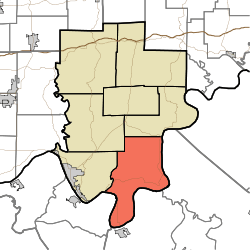 Location in Perry County | |
| Coordinates: 37°57′17″N 86°35′37″W / 37.95472°N 86.59361°WCoordinates: 37°57′17″N 86°35′37″W / 37.95472°N 86.59361°W | |
| Country |
|
| State |
|
| County | Perry |
| Government | |
| • Type | Indiana township |
| Area | |
| • Total | 65.55 sq mi (169.8 km2) |
| • Land | 63.91 sq mi (165.5 km2) |
| • Water | 1.65 sq mi (4.3 km2) 2.52% |
| Elevation | 538 ft (164 m) |
| Population (2010) | |
| • Total | 768 |
| • Density | 12/sq mi (5/km2) |
| ZIP codes | 47520, 47525, 47574, 47586 |
| GNIS feature ID | 453900 |
Tobin Township is one of seven townships in Perry County, Indiana, United States. As of the 2010 census, its population was 768 and it contained 418 housing units.[1]
History
Several members of the Tobin family were among the pioneer settlers who arrived to Tobin Township in the 1810s.[2]
The crash of Northwest Orient Airlines Flight 710, which killed 63 people on March 17, 1960 occurred in Tobin Township.
The Old Perry County Courthouse was listed on the National Register of Historic Places in 1981.[3]
Geography
According to the 2010 census, the township has a total area of 65.55 square miles (169.8 km2), of which 63.91 square miles (165.5 km2) (or 97.50%) is land and 1.65 square miles (4.3 km2) (or 2.52%) is water.[1]
Unincorporated towns
- Dodd at 37°54′44″N 86°39′07″W / 37.91228°N 86.651929°W
- Gerald at 38°00′27″N 86°34′23″W / 38.007561°N 86.573037°W
- Hardingrove at 37°55′37″N 86°34′17″W / 37.927004°N 86.57137°W
- Lauer at 37°52′45″N 86°36′06″W / 37.879225°N 86.601649°W
- Rome at 37°55′24″N 86°31′25″W / 37.923394°N 86.523591°W
- Tobinsport at 37°51′09″N 86°38′08″W / 37.852557°N 86.635539°W
(This list is based on USGS data and may include former settlements.)
Cemeteries
The township contains these twenty cemeteries: Brashear, Bryant, Carr, Cockrell-Tate, Conner, Connor, Cooks, David Tate, George Tate, German Ridge, Gilliand, Groves, Harding, Hiley, Lamb, Lamb, Lower Cummings, Maier, Miller, Robinson, Saint Johns, Saint Peters, Sampley, Schraner, Seibert, Shoemaker, Simons, Smith, Tate, Upper Cummings and Wegenast.
School districts
- Perry Central Community School Corporation
Political districts
- State House District 74
- State Senate District 47
References
- "Tobin Township, Perry County, Indiana". Geographic Names Information System. United States Geological Survey. Retrieved 2009-11-21.
- United States Census Bureau 2009 TIGER/Line Shapefiles
- IndianaMap
- 1 2 "Population, Housing Units, Area, and Density: 2010 - County -- County Subdivision and Place -- 2010 Census Summary File 1". United States Census. Retrieved 2013-05-10.
- ↑ Hunt, Thomas James De la (1916). Perry County: A History. W.K. Stewart. p. 17.
- ↑ National Park Service (2010-07-09). "National Register Information System". National Register of Historic Places. National Park Service.
External links
- Indiana Township Association
- United Township Association of Indiana
- City-Data.com page for Tobin Township
Places adjacent to Tobin Township, Perry County, Indiana | ||||||||||
|---|---|---|---|---|---|---|---|---|---|---|
| ||||||||||
Municipalities and communities of Perry County, Indiana, United States | ||
|---|---|---|
| Cities | ||
| Town | ||
| Townships | ||
| Unincorporated communities | ||