Las Palomas, New Mexico
| Las Palomas, New Mexico | |
|---|---|
| Census-designated place | |
 Las Palomas, New Mexico | |
| Coordinates: 33°03′45″N 107°17′54″W / 33.06250°N 107.29833°WCoordinates: 33°03′45″N 107°17′54″W / 33.06250°N 107.29833°W | |
| Country | United States |
| State | New Mexico |
| County | Sierra |
| Area[1] | |
| • Total | 1.599 sq mi (4.14 km2) |
| • Land | 1.599 sq mi (4.14 km2) |
| • Water | 0 sq mi (0 km2) |
| Elevation | 4,268 ft (1,301 m) |
| Population (2010)[1] | |
| • Total | 173 |
| • Density | 110/sq mi (42/km2) |
| Time zone | UTC-7 (Mountain (MST)) |
| • Summer (DST) | UTC-6 (MDT) |
| Area code(s) | 575 |
| GNIS feature ID | 899716[2] |
Las Palomas is a census-designated place in Sierra County, New Mexico, United States. Its population was 173 as of the 2010 census.[1] The community is located near Exit 71 of Interstate 25; New Mexico State Road 187 also passes through the community.
Geography
Las Palomas is located at 33°03′32″N 107°17′54″W / 33.058904°N 107.298221°W. According to the U.S. Census Bureau, the community has an area of 1.599 square miles (4.14 km2), all of it land.[1]
References
- 1 2 3 4 "2010 Census Gazetteer Files - Places: New Mexico". U.S. Census Bureau. Retrieved August 21, 2014.
- ↑ "Las Palomas". Geographic Names Information System. United States Geological Survey.
Municipalities and communities of Sierra County, New Mexico, United States | ||
|---|---|---|
| Cities | 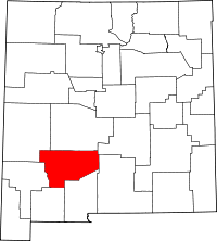 | |
| Villages | ||
| CDPs | ||
| Other communities | ||
| Ghost towns | ||
This article is issued from
Wikipedia.
The text is licensed under Creative Commons - Attribution - Sharealike.
Additional terms may apply for the media files.