Cameron Corner, Queensland
| Cameron Corner Bulloo Shire, Queensland | |||||||||||||||
|---|---|---|---|---|---|---|---|---|---|---|---|---|---|---|---|
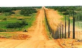
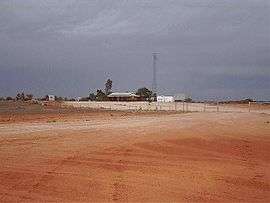 Cameron Corner, 2001 | |||||||||||||||
 Cameron Corner | |||||||||||||||
| Coordinates | 28°30′55″S 141°31′45″E / 28.51528°S 141.52917°ECoordinates: 28°30′55″S 141°31′45″E / 28.51528°S 141.52917°E | ||||||||||||||
| Postcode(s) | 2880 | ||||||||||||||
| LGA(s) | Bulloo Shire | ||||||||||||||
| State electorate(s) | Warrego | ||||||||||||||
| Federal Division(s) | Maranoa | ||||||||||||||
| |||||||||||||||
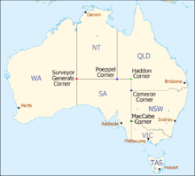
Cameron Corner is a locality in the Shire of Bulloo, Queensland, Australia.[1] It is located about 1,400 kilometres (870 mi) west-southwest of Brisbane, Queensland and is the point in the outback of eastern Australia where the boundary lines of the states of Queensland, South Australia, and New South Wales meet (the area immediately to the north and east of the intersection of the state boundaries).The noted Dingo Fence passes through Cameron Corner along the New South Wales border.
History
The corner and locality are named for the surveyor, John Brewer Cameron, from the New South Wales Lands Department, who spent two years during 1880–1882 marking the border between New South Wales and Queensland.[1] Cameron erected a post there in September 1880 to mark its intersection with the border of South Australia. He placed a wooden marker every mile (1.6 km) eastwards along the interstate boundary.
This general area, which includes Sturt Stony Desert in the Lake Eyre Basin, was first explored by Captain Charles Sturt, who in 1844 went in search of a supposed inland sea in the center of Australia.
Facilities
The Cameron Corner Store was established in 1990 by a Vietnam War veteran, Sandy Nall, and his wife Cathrine.[2] As of 2014, the store is operated by the sole permanent residents of Cameron Corner, Fenn and Cheryl Miller.[2] The store reportedly has a Queensland liquor licence, a New South Wales postal code and a South Australian telephone number.[3] The locality also features a desert golf course.[4]
Events
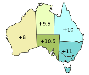
New Year's Eve is celebrated three times each year in Cameron Corner (also in Poeppel Corner and Surveyor Generals Corner), because the three states that meet at the corner are in three time zones.
Heritage listings
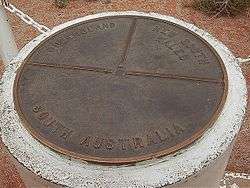
Cameron Corner Survey Marker which marks the corner is a heritage-listed site, being listed on the Queensland Heritage Register in 2012.[5]
References
- 1 2 "Cameron Corner (entry 42943)". Queensland Place Names. Queensland Government. Retrieved 16 May 2014.
- 1 2 Cherie von Hörchner (11 April 2014). "It's not so lonely in the corner". Australian Broadcasting Corporation. Retrieved 22 October 2015.
- ↑ Cameron Corner, Qweekend (The Courier Mail), 3–4 December 2005.
- ↑ ABC staff (2 February 2007). "Remote golf course sees first ever grass". ABC online. Australian Broadcasting Corporation. Retrieved 29 September 2012.
- ↑ "Cameron Corner (entry 602806)". Queensland Heritage Register. Queensland Heritage Council. Retrieved 7 July 2013.
External links
![]()
| Corners in Australia | |||||
|---|---|---|---|---|---|
| Name | Surveyor Generals | Poeppel | Haddon | Cameron | MacCabe |
| States | WA/NT/SA | NT/SA/Qld | SA/Qld | SA/Qld/NSW | SA/Vic/NSW |