Calgary–Edmonton Corridor
| Calgary–Edmonton Corridor | |
|---|---|
| Geographic Region | |
 The corridor consists of Alberta's three most densely populated census divisions and three largest cities. | |
| Nickname(s): CalEd Corridor | |
| Coordinates: 52°N 114°W / 52°N 114°WCoordinates: 52°N 114°W / 52°N 114°W | |
| Country | Canada |
| Province | Alberta |
| Area (2011)[1] | |
| • Total | 38,323.18 km2 (14,796.66 sq mi) |
| Population (2016)[2] | |
| • Total | 3,074,223 |
| • Density | 80.21/km2 (207.7/sq mi) |
| Time zone | UTC-7 (MST) |
| • Summer (DST) | UTC-6 (MDT) |
| Forward sortation areas | T1S to T1V, T1X to T4S, T4X to T7A, T7X to T8R, T8T, T9A, T9E to T9G, T0C (part), T0E (part) |
| Area code(s) | 403, 780, 587, 825 |
| Highways | 1, 1A, 2, 2A, 8, 11, 11A, 14, 15, 16, 16A, 22X, 28, 28A, 37, 100, 201, 216, 595 |
| Waterways | Bow River, Elbow River, North Saskatchewan River, Red Deer River, Battle River, Blindman River, Medicine River, Rosebud River, Sturgeon River, Raven River, North Raven River, Sheep River, Little Bow River, Highwood River, Brazeau River |
The Calgary–Edmonton Corridor is a geographical region of the Canadian province of Alberta. It is the most urbanized area in Alberta and is one of Canada's four most urban regions.[3] It consists of Statistics Canada Alberta census divisions No. 11, No. 8, and No. 6. Measured from north to south, the region covers a distance of approximately 400 km (250 mi). It includes the entire census metropolitan areas of Calgary and Edmonton and the census agglomerations of Red Deer and Wetaskiwin.[4]
Transportation
Alberta Highway 2 (also known as the Queen Elizabeth II Highway or QE2), the busiest highway in Alberta, is the central spine of the corridor. A Canadian Pacific rail line roughly parallels the QE2 and Highway 2A; it is only used by freight trains, and there is no passenger rail service between the two cities.
The corridor has two major international airports – Calgary International and Edmonton International. The airports are connected by 20 Air Canada and 10 WestJet flights a day, helping to make it one of Canada's busiest commuter flight routes.
Demographics
In the Canada 2001 Census, the population of the Calgary–Edmonton Corridor was 2,149,586, representing 72.3% of Alberta's population.[5] In the Canada 2011 Census, the corridor's population had increased to 2,703,380 or 74.2% of the province's population.
The following presents the historic population growth of the Calgary–Edmonton Corridor between 1996 and 2011 by its three census divisions.
| Census division | Area (km²)[1] |
Pop. (2011)[1] |
Pop. (2006)[6] |
Pop. (2001)[7] |
Pop. (1996)[7] |
|---|---|---|---|---|---|
| Division No. 6 | 12,645.88 | 1,311,022 | 1,160,936 | 1,021,060 | 880,859 |
| Division No. 8 | 9,909.31 | 189,243 | 175,337 | 153,049 | 133,592 |
| Division No. 11 | 15,767.99 | 1,203,115 | 1,076,103 | 975,477 | 898,888 |
| Calgary–Edmonton Corridor | 38,323.18 | 2,703,380 | 2,412,376 | 2,149,586 | 1,913,339 |
| Province of Alberta | 640,081.87 | 3,645,257 | 3,290,350 | 2,974,807 | 2,696,826 |
| Provincial proportion | 6.0% | 74.2% | 73.3% | 72.3% | 70.9% |
Growth
The Calgary–Edmonton Corridor is one of the fastest growing regions in the country because of the surging wealth of oil during the early 21st century. A 2003 study by TD Bank Financial Group found GDP per capita in the corridor is 10% above average U.S. metropolitan areas and 40% above other Canadian cities. Much of this is because of large oil revenues.[8]
Census subdivisions
The following are lists of the census subdivisions within the Calgary Metropolitan Region and Edmonton Metropolitan Region portions of the Calgary–Edmonton Corridor. The Edmonton Metropolitan Region's eight summer villages are not listed.
|
|
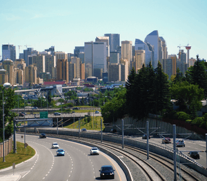 Calgary is the largest city in the province of Alberta 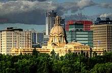 Alberta Legislature Building in Edmonton, the capital of Alberta 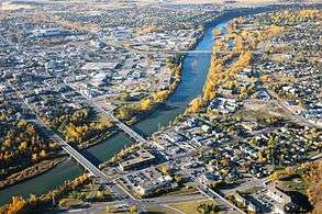 Red Deer, the third largest city in Alberta, is halfway between Calgary and Edmonton.
|
See also
References
- 1 2 3 "Population and dwelling counts, for Canada, provinces and territories, and census divisions, 2011 and 2006 censuses (Alberta)". Statistics Canada. February 8, 2012. Retrieved June 25, 2012.
- ↑ http://www12.statcan.gc.ca/census-recensement/2016/as-sa/fogs-spg/Facts-cd-eng.cfm?LANG=Eng&GK=CD&GC=4808
- ↑ "2001 Census Analysis Series - A profile of the Canadian population : where we live" (PDF). Statistics Canada. p. 6. Retrieved August 17, 2011.
- ↑ "Calgary–Edmonton Corridor: Population Change, 1996 – 2001 by 2001 Census Subdivision". Statistics Canada. 2002. Retrieved August 17, 2011.
- ↑ "Canada's major urban regions – The Calgary-Edmonton corridor". Statistics Canada. Retrieved August 17, 2011.
- ↑ "Population and dwelling counts, for Canada, provinces and territories, and census divisions, 2006 and 2001 censuses - 100% data (Alberta)". Statistics Canada. January 6, 2010. Retrieved June 25, 2012.
- 1 2 "Population and Dwelling Counts, for Canada, Provinces and Territories, and Census Divisions, 2001 and 1996 Censuses - 100% Data (Alberta)". Statistics Canada. Retrieved June 25, 2012.
- ↑ "The Calgary-Edmonton Corridor" (PDF). TD Bank Financial Group. April 22, 2003. Archived from the original (PDF) on July 23, 2004. Retrieved December 13, 2009.
External links
| Subdivisions | |
|---|---|
| Communities | |
| Cities and urban service areas | |
| Regions | |
| |