Caesar Creek Township, Dearborn County, Indiana
| Caesar Creek Township | |
|---|---|
| Township | |
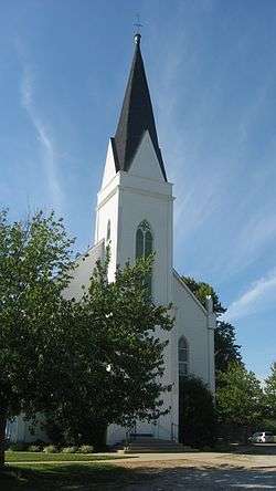 St. John's Lutheran Church, a historic site in the township | |
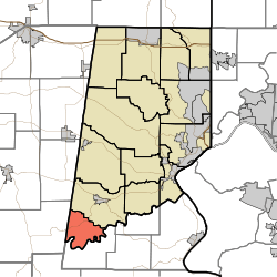 Location of Caesar Creek Township in Dearborn County | |
| Coordinates: 38°58′11″N 85°05′55″W / 38.96972°N 85.09861°WCoordinates: 38°58′11″N 85°05′55″W / 38.96972°N 85.09861°W | |
| Country | United States |
| State | Indiana |
| County | Dearborn |
| Government | |
| • Type | Indiana township |
| Area | |
| • Total | 11.94 sq mi (30.9 km2) |
| • Land | 11.94 sq mi (30.9 km2) |
| • Water | 0 sq mi (0 km2) |
| Elevation[1] | 879 ft (268 m) |
| Population (2010) | |
| • Total | 238 |
| • Density | 19.9/sq mi (7.7/km2) |
| FIPS code | 18-09730[2] |
| GNIS feature ID | 453151 |
Caesar Creek Township is one of fourteen townships in Dearborn County, Indiana. As of the 2010 census, its population was 238 and it contained 119 housing units.[3]
History
Caesar Creek Township was established in 1826.[4]
St. John's Lutheran Church and School was added to the National Register of Historic Places in 1996.[5]
Geography
According to the 2010 census, the township has a total area of 11.94 square miles (30.9 km2), all land.[3]
Unincorporated towns
(This list is based on USGS data and may include former settlements.)
Major highways
Cemeteries
The township contains three cemeteries: Mount Hebron, Rand and Saint Johns.
Education
Caesar Creek Township residents may obtain a library card at the Aurora Public Library in Aurora.[6]
References
- "Caesar Creek Township, Dearborn County, Indiana". Geographic Names Information System. United States Geological Survey. Retrieved 2009-09-24.
- United States Census Bureau cartographic boundary files
- ↑ "US Board on Geographic Names". United States Geological Survey. 2007-10-25. Retrieved 2008-01-31.
- ↑ "American FactFinder". United States Census Bureau. Archived from the original on 2013-09-11. Retrieved 2008-01-31.
- 1 2 "Population, Housing Units, Area, and Density: 2010 - County -- County Subdivision and Place -- 2010 Census Summary File 1". United States Census. Retrieved 2013-05-10.
- ↑ Shaw, Archibald (1915). History of Dearborn County, Indiana: Her People, Industries and Institutions. Unigraphic. p. 147.
- ↑ National Park Service (2010-07-09). "National Register Information System". National Register of Historic Places. National Park Service.
- ↑ "FAQ". Aurora Public Library District. Retrieved 4 March 2018.
External links
Places adjacent to Caesar Creek Township, Dearborn County, Indiana | ||||||||||
|---|---|---|---|---|---|---|---|---|---|---|
| ||||||||||
Municipalities and communities of Dearborn County, Indiana, United States | ||
|---|---|---|
| Cities | ||
| Towns | ||
| Townships | ||
| CDPs | ||
| Other unincorporated communities | ||
This article is issued from
Wikipedia.
The text is licensed under Creative Commons - Attribution - Sharealike.
Additional terms may apply for the media files.