Hancock, New York
| Hancock, New York | |
|---|---|
| Town | |
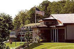 Family Foundation School in Hancock (now closed) | |
| Motto(s): "Gateway to the Upper Delaware" | |
 Hancock Location within the state of New York | |
| Coordinates: 41°57′19″N 75°17′15″W / 41.95528°N 75.28750°WCoordinates: 41°57′19″N 75°17′15″W / 41.95528°N 75.28750°W | |
| Country | United States |
| State | New York |
| County | Delaware |
| Government | |
| • Type | Town Council |
| • Town Supervisor | Samuel Rowe |
| • Town Council |
Members
|
| Area[1] | |
| • Total | 161.82 sq mi (419.10 km2) |
| • Land | 158.83 sq mi (411.36 km2) |
| • Water | 2.99 sq mi (7.75 km2) |
| Elevation | 922 ft (281 m) |
| Population (2010)[2] | |
| • Total | 3,224 |
| • Estimate (2016)[3] | 3,050 |
| • Density | 19.20/sq mi (7.41/km2) |
| Time zone | UTC-5 (Eastern (EST)) |
| • Summer (DST) | UTC-4 (EDT) |
| ZIP code | 13783 |
| Area code(s) | 607 |
| FIPS code | 36-025-31951 |
| GNIS feature ID | 0952148[4] |
| Website |
www |
Hancock is a town in Delaware County, New York, United States. The town contains a village, also named Hancock. The town is in the southwest part of the county. The population was 3,224 at the 2010 census.[2]
History
This town was established in 1806 from part of the town of Colchester. It is named for John Hancock, signer of the Declaration of the Independence.[5]
Geography
The southwest town line, delineated by the Delaware River, is the border of Pennsylvania. The East Branch of the Delaware flows from east to west across the town, joining the West Branch at Hancock village to form the Delaware River proper. Upstream from Hancock village, the town line and state line are formed by the West Branch. NY Route 17 passes through the town, with access from Exits 87 through 90.
According to the United States Census Bureau, the town has a total area of 161.8 square miles (419.1 km2), of which 158.8 square miles (411.3 km2) is land and 3.0 square miles (7.8 km2), or 1.85%, is water.[6]
Demographics
| Historical population | |||
|---|---|---|---|
| Census | Pop. | %± | |
| 1820 | 525 | — | |
| 1830 | 766 | 45.9% | |
| 1840 | 1,026 | 33.9% | |
| 1850 | 1,798 | 75.2% | |
| 1860 | 2,862 | 59.2% | |
| 1870 | 3,069 | 7.2% | |
| 1880 | 3,238 | 5.5% | |
| 1890 | 4,745 | 46.5% | |
| 1900 | 5,308 | 11.9% | |
| 1910 | 5,191 | −2.2% | |
| 1920 | 4,122 | −20.6% | |
| 1930 | 3,953 | −4.1% | |
| 1940 | 3,813 | −3.5% | |
| 1950 | 3,517 | −7.8% | |
| 1960 | 3,907 | 11.1% | |
| 1970 | 3,604 | −7.8% | |
| 1980 | 3,497 | −3.0% | |
| 1990 | 3,384 | −3.2% | |
| 2000 | 3,450 | 2.0% | |
| 2010 | 3,224 | −6.6% | |
| Est. 2016 | 3,050 | [3] | −5.4% |
| U.S. Decennial Census[7] | |||
As of the census[8] of 2000, there were 3,449 people, 1,390 households, and 913 families residing in the town. The population density was 21.6 people per square mile (8.4/km²). There were 2,512 housing units at an average density of 15.8 per square mile (6.1/km²). The racial makeup of the town was 96.69% White, 0.70% Black or African American, 0.52% Native American, 0.61% Asian, 0.32% from other races, and 1.16% from two or more races. Hispanic or Latino of any race were 2.38% of the population.
There were 1,390 households out of which 28.6% had children under the age of 18 living with them, 52.3% were married couples living together, 8.1% had a female householder with no husband present, and 34.3% were non-families. 30.1% of all households were made up of individuals and 15.5% had someone living alone who was 65 years of age or older. The average household size was 2.48 and the average family size was 3.01.
In the town, the population was spread out with 24.1% under the age of 18, 5.9% from 18 to 24, 24.1% from 25 to 44, 27.0% from 45 to 64, and 18.9% who were 65 years of age or older. The median age was 42 years. For every 100 females, there were 98.4 males. For every 100 females age 18 and over, there were 94.9 males.
The median income for a household in the town was $30,449, and the median income for a family was $37,125. Males had a median income of $28,259 versus $21,875 for females. The per capita income for the town was $16,057. About 8.4% of families and 14.3% of the population were below the poverty line, including 19.3% of those under age 18 and 13.4% of those age 65 or over.
Notable natives and residents
- Henry Bidleman Bascom (1796-1850), religious circuit rider, Methodist bishop, chaplain to US Congress
- Clark L. Hood (1847-1920), Wisconsin State Assemblyman and lawyer
- "Honest Eddie" Murphy, baseball player, appeared in three World Series
Communities and locations in the Town of Hancock
- Cadosia — A hamlet northeast of Hancock village.
- Centerville — A location in the north part of the town on New York State Route 30.
- Chiloway — A hamlet southwest of Peakville.
- East Branch - The Hotel Delaware was listed on the National Register of Historic Places in 2004.[9]
- Fishs Eddy — A hamlet northeast of Hancock village on New York State Route 17.
- French Woods — A hamlet near the center of the town on New York State Route 97.
- Goulds — A hamlet near the east town line. See Gould Cemetery website
- Hancock — A village by the west town line.
- Harvard — A location near the northeast town line on New York State Route 30.
- Kelsey — A hamlet at the northwest town line north of Hancock village and south of Cannonsville Reservoir.
- Kerry Siding — A hamlet at the northwest town line.
- Kerryville — A hamlet at the northwest town line.
- Kilgore Spur — A location west of Lordville.
- Long Flat — A location near the northeast town line.
- Lordville — A hamlet by the Delaware River in the south part of the town. The Lordville Presbyterian Church and the Ravina historic district are listed on the National Register of Historic Places.[9]
- Luzerne — A hamlet southeast of Fishs Eddy on New York State Route 28.
- Methol — The Lower Shavertown Covered Bridge was listed on the National Register of Historic Places in 1999.[9]
- Peakville — A hamlet west of East Branch (historically called Trout Brook).
- Pea Brook — A location in the south part of the town on New York State Route 97.
- Peas Eddy — A hamlet east of Hancock village by the Delaware River.
- Readburn — A hamlet in the north part of the town.
- Rock Valley — A hamlet by the east town line. The Rock Valley School was listed on the National Register of Historic Places in 2008.[9]
- Tylers Switch — A hamlet east of Hancock village near New York State Route 17.
References
- ↑ "2016 U.S. Gazetteer Files". United States Census Bureau. Retrieved Jul 4, 2017.
- 1 2 "American FactFinder". United States Census Bureau. Retrieved 2011-05-14.
- 1 2 "Population and Housing Unit Estimates". Retrieved June 9, 2017.
- ↑ "US Board on Geographic Names". United States Geological Survey. 2007-10-25. Retrieved 2008-01-31.
- ↑ Gannett, Henry (1905). The Origin of Certain Place Names in the United States. Govt. Print. Off. p. 148.
- ↑ "Geographic Identifiers: 2010 Demographic Profile Data (G001): Hancock town, Delaware County, New York". U.S. Census Bureau, American Factfinder. Retrieved November 5, 2015.
- ↑ "Census of Population and Housing". Census.gov. Retrieved June 4, 2015.
- ↑ "American FactFinder". United States Census Bureau. Retrieved 2008-01-31.
- 1 2 3 4 National Park Service (2009-03-13). "National Register Information System". National Register of Historic Places. National Park Service.
External links
- Town of Hancock official website
- Town of Hancock at Chamber of Commerce site
Municipalities and communities of Delaware County, New York, United States | ||
|---|---|---|
| Towns | 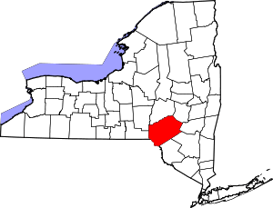 | |
| Villages | ||
| CDPs | ||
| Hamlets |
| |
| Footnotes | ‡This populated place also has portions in an adjacent county or counties | |