Cabin Run Covered Bridge
|
Cabin Run Covered Bridge | |
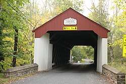 Cabin Run Covered Bridge, September 2012 | |
  | |
| Location | South of Tinicum on Legislative Route 09099 in Plumstead Township, Point Pleasant, Pennsylvania |
|---|---|
| Coordinates | 40°14′33″N 75°6′45″W / 40.24250°N 75.11250°WCoordinates: 40°14′33″N 75°6′45″W / 40.24250°N 75.11250°W |
| Area | 0.1 acres (0.040 ha) |
| Built | 1871 |
| Architectural style | Town truss |
| MPS | Covered Bridges of the Delaware River Watershed TR |
| NRHP reference # | 80003443[1] |
| Added to NRHP | December 1, 1980 |
The Cabin Run Covered Bridge is a historic covered bridge located in Point Pleasant, Plumstead Township, Bucks County, Pennsylvania. The bridge was built in 1871, and is 15 feet (4.6 m) wide and has a length of 82 feet (25 m). The Town truss bridge crosses the Cabin Run Creek downstream from the Loux Covered Bridge.[2][3]
It was added to the National Register of Historic Places on December 1, 1980.[1]
See also
References
- 1 2 National Park Service (2009-03-13). "National Register Information System". National Register of Historic Places. National Park Service.
- ↑ Bucks County Covered Bridge Society. "Covered Bridges of Bucks County" (PDF). Brochure. Archived from the original (PDF) on 2013-12-03. Retrieved 2012-09-27.
- ↑ "National Historic Landmarks & National Register of Historic Places in Pennsylvania" (Searchable database). CRGIS: Cultural Resources Geographic Information System. Note: This includes Susan M. Zacher (n.d.). "National Register of Historic Places Inventory Nomination Form: Cabin Run Covered Bridge" (PDF). Retrieved 2012-10-14.
| Wikimedia Commons has media related to Cabin Run Covered Bridge. |
External links
- Historic American Engineering Record (HAER) No. PA-197, "Cabin Run Covered Bridge, Schlentz Hill Road across Cabin Run, Pipersville, Bucks County, PA", 4 photos, 1 photo caption page
| Topics |   | |
|---|---|---|
| Lists by county |
| |
| Lists by city | ||
| Other lists | ||
| ||
This article is issued from
Wikipedia.
The text is licensed under Creative Commons - Attribution - Sharealike.
Additional terms may apply for the media files.