Trent Hills
| Trent Hills | |
|---|---|
| Township Municipality (Ontario, lower-tier municipality) | |
| Municipality of Trent Hills | |
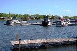 Hastings as seen across the Trent-Severn Waterway | |
 Trent Hills | |
| Coordinates: 44°18′51″N 77°51′05″W / 44.31417°N 77.85139°WCoordinates: 44°18′51″N 77°51′05″W / 44.31417°N 77.85139°W[1] | |
| Country |
|
| Province |
|
| County | Northumberland |
| Established | 2001 |
| Government | |
| • Governing Body | Trent Hills Municipal Council |
| • Federal riding | Northumberland—Quinte West |
| • Prov. riding | Northumberland—Quinte West |
| Area[2] | |
| • Land | 511.95 km2 (197.67 sq mi) |
| Population (2016)[2] | |
| • Total | 12,900 |
| • Density | 25.2/km2 (65/sq mi) |
| Time zone | UTC-5 (EST) |
| • Summer (DST) | UTC-4 (EDT) |
| Postal code | K0L |
| Area code(s) | 705, 249 |
| Website |
www |
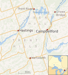 |
| Map of Trent Hills municipality[3] |
The Municipality of Trent Hills is a township municipality[1] in Northumberland County in Central Ontario, Canada.[1][3][4][5][6] It is on the Trent River[4][5] and was created in 2001 through the amalgamation of the municipalities of Campbellford/Seymour, Percy Township and Hastings.[3] Thereafter it was briefly known as Campbellford/Seymour, Percy, Hastings.
Communities
The municipality was historically four separate administrative subdivisions: the former town of Campbellford; the former village of Hastings; Seymour Township; and Percy Township. The latter two retain the status of geographic townships.[3]
There are three population centres in Trent Hills: Campbellford; Hastings; and the former village of Warkworth, formerly the municipal seat of Percy Township prior to the amalgamation of Trent Hills. Smaller communities within the municipality include Allan Mills, Brickley, Burnbrae, Connellys, Crowe Bridge, Dartford, English Line, Godolphin, Green Acres, Healey Falls, Hoards Station, Kellers, Menie, Meyersburg, Norham, Percy Boom, Pethericks Corners, Stanwood, Sunnybrae, Trent River, West Corners, Westview and Woodland.
Demographics
| Canada census – Trent Hills community profile | |||
|---|---|---|---|
| 2016 | 2011 | ||
| Population: | 12,900 (2.3% from 2011) | 12,604 (2.9% from 2006) | |
| Land area: | 511.95 km2 (197.67 sq mi) | 511.90 km2 (197.65 sq mi) | |
| Population density: | 25.2/km2 (65/sq mi) | 24.6/km2 (64/sq mi) | |
| Median age: | 53.5 (M: 52.9, F: 53.9) | 51.0 (M: 50.6, F: 51.4) | |
| Total private dwellings: | 6883 | 6613 | |
| Median household income: | |||
| References: 2016[2] 2011[7] earlier[8] | |||
Mother tongue:[2]
- English as first language: 94.8%
- French as first language: 1.1%
- English and French as first language: 0%
- Other as first language: 3.8%
Population trend:[9]
- Population in 2016: 12,900
- Population in 2011: 12,604
- Population in 2006: 12,247
- Population in 2001: 12,569
- Population total in 1996: 12,437
- Campbellford (town): 3647
- Hastings (village): 1140
- Percy (township): 3208
- Seymour (township): 4442
- Population in 1991:
- Campbellford (town): 3528
- Hastings (village): 1148
- Percy (township): 3191
- Seymour (township): 4347
Government
The chart below shows the structure of the municipal government of Trent Hills. These politicians were elected as of the 2014 municipal election. Following the death of Hector Macmillan who had served as an elected official from 2003 until 2017,[10] deputy mayor Bob Crate was elected mayor and Rosemary Kelleher-MacLennan deputy mayor by council.[11]
| Mayor | Ward 1 - Campbellford/Seymour | Ward 2 - Percy | Ward 3 - Hastings |
|---|---|---|---|
| Robert (Bob) Crate | Catherine Redden | Rick English | Mike Metcalf |
| Rosemary Kelleher-MacLennan (deputy mayor) | Ken Tully | ||
| William (Bill) J. Thompson | |||
The Member of Parliament for the riding of Northumberland-Quinte West is Kim Rudd of the Liberal Party of Canada.[12] The Member of Provincial Parliament for Northumberland-Peterborough South is David Piccini of the Progressive Conservative Party of Ontario.[13]
See also
References
- 1 2 3 "Trent Hills". Geographical Names Data Base. Natural Resources Canada. Retrieved 2018-08-28.
- 1 2 3 4 "2016 Community Profiles". Canada 2016 Census. Statistics Canada. February 21, 2017. Retrieved 2017-11-25.
- 1 2 3 4 Restructured municipalities - Ontario map #5 (Map). Restructuring Maps of Ontario. Ontario Ministry of Municipal Affairs and Housing. 2006. Retrieved March 20, 2018.
- 1 2 "Toporama". Atlas of Canada. Natural Resources Canada. Retrieved 2018-08-28.
- 1 2 "Ontario Geonames GIS (on-line map and search)". Ontario Ministry of Natural Resources and Forestry. 2014. Retrieved 2018-08-28.
- ↑ Map 6 (PDF) (Map). 1 : 700,000. Official road map of Ontario. Ministry of Transportation of Ontario. 2018-01-01. Retrieved 2018-08-28.
- ↑ "2011 Community Profiles". Canada 2011 Census. Statistics Canada. July 5, 2013. Retrieved 2012-03-12.
- ↑ "2001 Community Profiles". Canada 2001 Census. Statistics Canada. February 17, 2012.
- ↑ Statistics Canada: 1996, 2001, 2006, 2011, 2016 Census
- ↑ globalnews.ca "Longtime Trent Hills mayor Hector Macmillan loses battle with cancer", October 11, 2017
- ↑ trenthills.ca Media-Release-Trent-Hills-November-8-Robert-Crate-Appointed-Mayor-2017.pdf "Media release: Robert Crate Appointed as Mayor of Trent Hills", November 8, 2017
- ↑ "Members of the House of Commons". National Parliament website. Retrieved 2009-01-17.
- ↑ "Current MPPs". Ontario Parliament website. Retrieved 2017-11-25.
External links
| Wikimedia Commons has media related to Trent Hills. |
- Official website
- Trent Hills & District Chamber of Commerce
- Trent Hills Tourism
- Northumberland Tourism
Places adjacent to Trent Hills | |
|---|---|