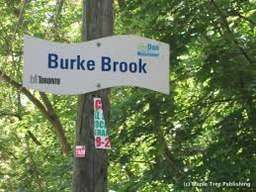
Burke Brook
Coordinates: 43°43′02″N 79°23′20″W / 43.717124°N 79.388756°W
| Burke Brook | |
| Brook | |
 | |
| Country | Canada |
|---|---|
| State | Ontario |
| Region | GTA |
| Municipality | Toronto |
| Part of | Don River |
| Tributaries | |
| - left | Havergal Stream |
| City | Toronto |
| Source | Chatsworth Ravine |
| - location | Glenview Senior Public School, Canada |
| - elevation | 178 m (584 ft) |
| - coordinates | 43°43′14″N 79°24′29″W / 43.720583°N 79.408013°W |
| Mouth | Don River |
| - location | Sunnybrook Park, Canada |
| - elevation | 134 m (440 ft) |
| - coordinates | 43°43′14″N 79°21′56″W / 43.720586°N 79.365653°W |
| Length | 9 km (6 mi) |
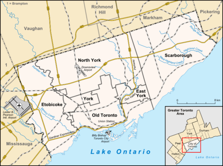 Location of the mouth of the creek in Toronto | |
Burke Brook is a small stream in Toronto, Ontario. It is part of the Don River watershield, a major river that feeds into Lake Ontario. The north end of the river ends around Glenview Senior Public School.[1]
History
Burke Brooke used to start near Downsview Airport. The stream then went down in a south-east direction where it meets the beginning of the stream today (just east of Glenview Senior Public School). After that the stream follows the current course where it meets up with the West Don River. The total length of the stream was 9 km with 6 km being tributaries.[2]
Historic tributaries
The Burke Brooke has a total of 6 km of tributary streams. The first one (the nearest to the Don River) was the Blythwood Stream which started by Glengowan Road and Strathgowan nd also at Saint Leonards Avenue and Saint Ives Avenue. The two section merged at Strathgowan Road and Fidelia Avenue. The stream followed a course running just east of Blythdale Road almost parallel until it meet Burke Brook. The length of the stream was around 1 km.[3]
The next stream was the Lawrence Park Stream with also merged with the McDougall Stream By the Locke Library between Lawrence and Lympstone.The length of the lawrence park stream was 6 km and the McDougall Stream was 1 km. The Lawrence Park Stream started by Wilson Avenue and Avenue Road, the headed to the point where it meet the McDougall Stream then it continued on to meet the Burke Brooke by Young Street and Saint Edmurds Drive. The McDougall stream started Just north of the Blythwood Stream and curved until the place Where it meet the Lawrence Park Stream.[4]
The last and furthest tributary was the Havergal Stream. The stream started under the intersection of Old Orchard Grover and Barse Street by the Baycrest Hospital. The length of the river was 1.5 km. The river let its source and proceed in a south-south-east direction to the Current Grounds of Havergal School, where nowadays it pops ups from the ground. The stream then went to where the current North Toronto Storm Trunk Sewer is and them meet the Burke Brooke a little east of there.[5]
Feeder river and sewers
Current feeder rivers
The stream now only has one Tributary the Havergal Stream. The Havergal Stream runs entirely through the property of Havergal School. The start of the stream is feed by local sewers and nearby springs.[5] The Havergal Stream them proceeds to meet the North Toronto Storm Trunk Sewer at the edge of the property. Then the water of the stream is flowed out into the North Toronto Storm Trunk Sewer, were the sewer meets the Burke Brooke.[5]
Major feeder sewers
The Burke Brooke has one major feeder sewer, the North Toronto Storm Trunk Sewer. The North Toronto Storm Trunk Sewer meets the Burke Brooke were it starts near Glenview Senior Public School. The sewer has two section one starts at Lawrence Avenue and follows the old Burke Brooke and the other starts at Douglass Avenue and Bathurst Street. The North Toronto Storm Trunk Sewer was a Metro project installed during the 60s and 70s. Similar to other sewers build it was made to help reduce sewage along the planned route for the Spadina expressway. It was also made to allow particle sewage separation in boroughs served by smaller sewage plants, and to open up more land for development. The sewer also links up with the North York Storm Trunk Sewer by Douglass Avenue and Bathurst Street.[6]
Parks
Parks are in order from east to west.
.JPG)
Sunnybrook Park
Sunnybrook Park is a major park in Toronto that connects to the Don Valley (it's west of the Don Valley). It is home to the Sunnybrook Stables, Dog parks and many sport fields. There are also a lot of bike and walking paths, with a few car permitted roads here and there. The park is also known for its cricket.[7]
Burke Brook Ravine
The Burke Brook Ravine is a ravine that stretches from Sunnybrook Park and to Bayview Avenue. The ravine has no trail connection to Bayview Avenue but it still accessible from Bayview Avenue via a few very steep slopes.[8]
Sunnydene park
Sunnydene Park is a small park just to the east of Sherwood Park, to the west of Bayview Ave.The park is very close to Sherwood Park and the maps included it as part of Sherwood Park[1]
Sherwood Park
Sherwood Park is a park in Toronto. It contains a city maintenance building, a water park, a playground, and washrooms. It contains 2 paths to the left and right of the Burke Brook. It contains a dog-off-leash park to the south-east north of the Mount Hope Catholic Cemetery and west of Sunnydene Park. To the north of the park is Blythwood Road and the Blythwood Ravine. A road leads west out of the park to Sherwood Avenue.
Blythwood Ravine Park
Blythwood Ravine Park is a ravine between Alexander Muir Memorial Gardens and Blythwood Road.It also has entrances and the end of Strathgowan Avenue and Glengowan Road. The park is quite skinny and acts as a connector park between Sherwood park and Alexander Muir Memorial Gardens/ Yonge Street.[1]
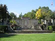
Alexander Muir Memorial Gardens
This park is between Blythwood Ravine Park and Yonge Street. It has the tennis courts of the Lawrence Park Tennis Club and the Fields of the Lawrence Park Lawn Bowling and Croquet Club. The main attraction of the park is the song The Maple Leaf Forever the unofficial anthem of Canada[9] printed on a stone wall with stairs connect the fields of the park and the gardens of the park. Originally the park was located on the west side of Yonge Street across from the Mount Pleasant Cemetery to celebrate the Toronto centennial celebrations. But to build the Yonge Subway the TTC paid over 100 thousand dollars to move the park including the stone wall the current location in Lawrence Park.[10][11][12]
Duplex Parkette (and Glenview Parkette)
In Duplex Parkette, Burke Brook is underground in some pipes. Glenview Parkette is two islands with pathways running through them.[1]
Chatsworth Ravine
Chatsworth is a ravine between duplex Avenue and Glenview Senior Public School with a path running to Cheritan Avenue. It has a bridge in the middle moving the path from south of the river to north of the river.[1]
Street crossings
In order from east to west:
- Bayview Avenue - No traffic/ pedestrian lights (Kilgour Road has the closest Traffic light)
- Blythwood Road - Pedestrian crossing lights
- Mount Pleasant Road - Path Goes under a bridge
- Yonge Street - No traffic/ pedestrian lights (Saint Edmunds Drive has closest traffic lights)
- Duplex Avenue - No traffic lights (Glenview Avenue has closest pedestrian crossings (stop sign))[1]
References
- 1 2 3 4 5 6 "Google Maps". Google Maps. Retrieved 2017-03-06.
- ↑ "Burke Brook". www.lostrivers.ca. Retrieved 2017-12-05.
- ↑ "Blythwood Stream". www.lostrivers.ca. Retrieved 2017-12-06.
- ↑ "Lawrence Park Stream". www.lostrivers.ca. Retrieved 2017-12-06.
- 1 2 3 "Havergal Stream". www.lostrivers.ca. Retrieved 2017-12-06.
- ↑ "North Toronto Storm Trunk Sewer | Vanishing Point". www.vanishingpoint.ca. Retrieved 2017-12-06.
- ↑ Recreation, Toronto Parks, Forestry and. "Parks, Forestry and Recreation : Sunnybrook Park". www.toronto.ca. Retrieved 2017-12-06.
- ↑ "311 Knowledge Base". www.toronto.ca. Retrieved 2017-12-06.
- ↑ Cumming, Don. "mapleleafforever". www.chebucto.ns.ca. Retrieved 2017-12-06.
- ↑ "Alexander Muir Memorial Gardens". www.lostrivers.ca. Retrieved 2017-12-06.
- ↑ "Lawrence Park". Lawrence Park. Retrieved 2017-12-06.
- ↑ "Lawrence Park Tennis Club | Lawrence Park Tennis Club". lawrenceparktennisclub.ca. Retrieved 2017-12-06.